
Kluane National Park and Reserve are two protected areas in the southwest corner of the territory of Yukon. The National Park Reserve was set aside in 1972 to become a national park, pending settlement of First Nations land claims. It covered an area of 22,013 square kilometres. When agreement was reached with the Champagne and Aishihik First Nations over an eastern portion of the Reserve, that part—about 5,900 square kilometres —became a national park in 1993, and is a unit of the national park system administered co-operatively with Parks Canada. The larger western section remains a Reserve, awaiting a final land claim settlement with the Kluane First Nation. The park borders British Columbia to the south, while the Reserve borders both British Columbia to the south, and the United States (Alaska) to the south and west.

Alsek River is a wilderness river flowing from Yukon into Northern British Columbia and into Alaska. It enters the Gulf of Alaska at Dry Bay.

Yukon is in the northwestern corner of Canada and is bordered by Alaska, British Columbia and the Northwest Territories. The sparsely populated territory abounds with natural scenery, snowmelt lakes and perennial white-capped mountains, including many of Canada's highest mountains. The territory's climate is Arctic in territory north of Old Crow, subarctic in the region, between Whitehorse and Old Crow, and humid continental climate south of Whitehorse and in areas close to the British Columbia border. Most of the territory is boreal forest with tundra being the main vegetation zone only in the extreme north and at high elevations.

Tatshenshini-Alsek Park or Tatshenshini-Alsek Provincial Wilderness Park is a provincial park in British Columbia, Canada. The park is 9,580 km2 (3,700 sq mi) in size. It was established in 1993 after an intensive campaign by Canadian and American conservation organizations to halt mining exploration and development in the area, and protect the area for its strong natural heritage and biodiversity values.

Kluane Lake is located in the southwest area of the Yukon. It is the largest lake contained entirely within Yukon at approximately 408 km2 (158 sq mi), and 81 km (50 mi) long.
The Alsek Ranges are the southeasternmost subdivision of the Saint Elias Mountains of the Pacific Cordillera. They span the region between the Alsek River, Glacier Bay and the Kelsall River. Their western boundary is the Grand Pacific Glacier, beyond which is the Fairweather Range, another subdivision of the St. Elias Mountains. To their east is the northernmost section of the Boundary Ranges, the northernmost subdivision of the Coast Mountains and which are also known as the Alaska Boundary Range, and which run south to the Nass River and form, as their name indicates, the spine of the boundary between the American state of Alaska and the Canadian province of British Columbia.

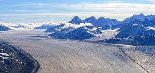
The Kaskawulsh Glacier is a vast, temperate valley glacier nestled in the St. Elias Mountains, within Kluane National Park in the Canadian territory of Yukon.

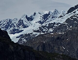
Mount Maxwell is a 3,020-metre (9,910-foot) mountain summit of the Saint Elias Mountains in Kluane National Park of Yukon, Canada. The mountain is situated at the toe of the Kaskawulsh Glacier. The mountain cannot be seen from any roads, but can be seen from the Slims River valley. The nearest higher peak is Mount Leacock, 9.2 km (5.7 mi) to the south. The "Mt Maxwell" designation is misplaced five kilometres to the northeast of the actual summit on the topographic map. The mountain was named by John Oliver Wheeler, a Canadian geologist with the Geological Survey of Canada who climbed Maxwell in 1954. The Maxwell name was approved in 1960, and was made official in 1981 by the Geographical Names Board of Canada. However, it remains a mystery who Maxwell was. Based on the Köppen climate classification, Mount Maxwell is located in a subarctic climate with long, cold, snowy winters, and mild summers.

Mount Worthington is a 2,168-metre (7,113-foot) mountain summit in the Auriol Range of the Saint Elias Mountains, in Kluane National Park of Yukon, Canada. The mountain is situated above the shores of Kathleen Lake, 7.2 km (4 mi) northwest of Kings Throne Peak across the lake, and 19 km (12 mi) south-southeast of Haines Junction, Yukon. The mountain can be seen from the Haines Highway as it prominently rises 1,570-metre (5,150-foot) above the lake. The mountain's name was officially adopted August 12, 1980, by the Geographical Names Board of Canada. Based on the Köppen climate classification, Mount Worthington is located in a subarctic climate with long, cold, snowy winters, and mild summers.

Kings Throne Peak is a 1,990-metre (6,530-foot) mountain summit in the Dalton Range of the Saint Elias Mountains, in Kluane National Park of Yukon, Canada. The mountain is situated above the south shore of Kathleen Lake, 7.2 km (4 mi) southeast of Mount Worthington across the lake, and 27 km (17 mi) south-southeast of Haines Junction, Yukon. The mountain can be seen from the Haines Highway as it prominently rises 1,250-metre (4,100-foot) above the lake. The mountain's descriptive name comes from how it is shaped by a cirque on the north aspect. A rock glacier descends from the cirque to the lake. A steep five kilometre trail provides access to the amphitheatre, and an additional three kilometres on a beaten path reaches the summit via the east ridge. Based on the Köppen climate classification, Kings Throne Peak is located in a subarctic climate zone with long, cold, snowy winters, and mild summers.

Mount Cairnes is a 2,810-metre (9,220-foot) mountain summit in the Saint Elias Mountains on the boundary line of Kluane National Park in Yukon, Canada. The mountain is situated 44 km (27 mi) west of Haines Junction, 18 km (11 mi) southeast of Kluane Lake, and can be seen from the Alaska Highway midway between the two. Its nearest higher peak is Mount Maxwell, 27.7 km (17.2 mi) to the southwest. The mountain's name was officially adopted February 3, 1981, by the Geographical Names Board of Canada. Clive Elmore Cairnes (1892–1954) was active with the Geological Survey of Canada as well as the Geographic Board of Canada until his retirement in 1953. He was related to noted geologist DeLorme Donaldson Cairnes (1879–1917), for whom this mountain is named.
Mount Decoeli is a 2,332-metre (7,651-foot) pyramidal peak located in the Kluane Ranges of the Saint Elias Mountains in Yukon, Canada. The mountain is situated 23 km (14 mi) northwest of Haines Junction, 21.4 km (13 mi) east of Mount Cairnes, and can be seen from the Alaska Highway midway between the two. Its nearest higher peak is Mount Archibald, 6 km (3.7 mi) to the south. The mountain's name was officially adopted August 12, 1980, by the Geographical Names Board of Canada. James J. McArthur was a Canadian surveyor and mountaineer who undertook extensive surveying in the Yukon during his later years. In 1908 he made the first ascent of Williams Peak accompanied by Edmond Treau de Coeli (1873–1963). Decoeli is pronounced deh-coh-lie. To the Southern Tutchone people, the mountain is known as Nàday Gän, meaning Dried Lynx Mountain.

Mount Archibald is a prominent 2,588-metre (8,491-foot) mountain summit located in the Kluane Ranges of the Saint Elias Mountains in Yukon, Canada. The mountain is situated 21 km (13 mi) west of Haines Junction, 5.9 km (4 mi) south of Mount Decoeli, and 27 km (17 mi) east-southeast of Mount Cairnes, which is the nearest higher peak. Set on the boundary line of Kluane National Park, Archibald can be seen from the Alaska Highway, weather permitting. The mountain was named after Edgar Archibald (1885-1968), a Canadian agricultural scientist. The mountain's name was officially adopted August 12, 1980, by the Geographical Names Board of Canada. On a clear day, the summit offers views deep into Kluane National Park of giants such as Mt. Logan, Mt. Vancouver, and Mt. Kennedy.

Mount Martha Black, elevation 2,512-metre (8,241-foot), is the highest point in the Auriol Range of the Saint Elias Mountains in Yukon, Canada. The multi-summit massif is situated 11 km (7 mi) southwest of Haines Junction, 16 km (10 mi) northwest of Mount Worthington, and 18.6 km (12 mi) southeast of Mount Archibald, which is the nearest higher peak. Set within Kluane National Park, Mount Martha Black can be seen from the Alaska Highway, weather permitting. The mountain was named after Martha Black (1866-1957), the second woman elected to the House of Commons of Canada. The mountain's name was officially adopted August 12, 1980, by the Geographical Names Board of Canada.
Mount Turner, also known as Boundary Peak 162, is an 8,661+ foot glaciated mountain summit located in the Fairweather Range of the Saint Elias Mountains, on the Canada–United States border between southeast Alaska and British Columbia. The peak is situated on the shared boundary of Glacier Bay National Park with Tatshenshini-Alsek Provincial Park, 8 mi (13 km) west of Tarr Inlet, and 4.4 mi (7 km) southwest of Mount Forde, which is the nearest peak. Turner is the highest point on the divide which separates Ferris Glacier from Margerie Glacier. The mountain's name was officially adopted by the Geographical Names Board of Canada on March 31, 1924. The mountain was named for George Turner (1850–1932), one of the US members of the 1903 Alaska Boundary Tribunal.

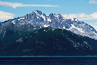
Sheep Mountain is a 1,953-metre (6,407-foot) mountain summit of the Saint Elias Mountains, in Kluane National Park of Yukon, Canada. It is known as Thechàl Dhâl by the Southern Tutchone people, meaning "Skin Scraper Mountain", referring to the thechàl, a flat stone scraper that was used to prepare animal hides. Sheep Mountain is habitat for Dall sheep, and was once a favorite sheep hunting area for the Southern Tutchone before the park was established. The mountain is a prominent landmark along the Alaska Highway, and topographic relief is significant as the summit rises 1,140 meters above the Thechàl Dhâl Visitor Centre at Kluane Lake in 2.5 kilometers. The mountain can be climbed via an 11 km (6.8 mi) loop which gains 1,310 meters of elevation, part of which is on the Sheep Creek Trail, one of the most popular hikes in Kluane Park. The route provides good opportunities to see Dall sheep, which the mountain is named for. The summit offers views up the Slims River valley to Mount Maxwell, south to Vulcan Mountain, and 2.4 km (1.5 mi) northwest to Mount Wallace, which is the nearest higher neighbor.

Pinnacle Peak is a remote 3,714-meter-elevation (12,184-foot) mountain summit of the Saint Elias Mountains, in Kluane National Park of Yukon, Canada. It ranks as the 37th-highest officially named mountain in Canada. It is situated at the head of the South Arm of the Kaskawulsh Glacier. Topographic relief is significant as the summit rises 1,500 meters (4,920 feet) above the Dusty Glacier in 3.5 kilometers. Neighbors include Mount Kennedy, 14 km to the south, and Mount Alverstone, 14 km to the south-southwest.

Mount Malaspina is a 3,776-metre (12,388-foot) mountain summit in Yukon, Canada.
Ulu Mountain is a mountain in Yukon, Canada.

Mount Newton is a 4,200-metre (13,780-foot) mountain summit in Yukon, Canada.


