You can help expand this article with text translated from the corresponding article in Finnish. (June 2023)Click [show] for important translation instructions.
|
Keitele | |
|---|---|
Municipality | |
| Keiteleen kunta Keitele kommun | |
 | |
 Coat of arms | |
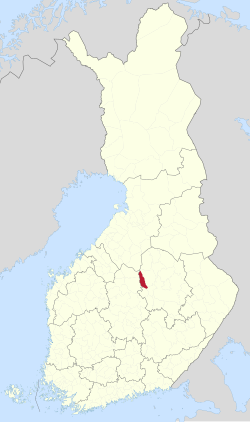 Location of Keitele in Finland | |
| Coordinates: 63°10.7′N026°21′E / 63.1783°N 26.350°E | |
| Country | |
| Region | North Savo |
| Sub-region | Upper Savo |
| Charter | 1879 |
| Government | |
| • Municipal manager | Hanna Helaste |
| Area (2018-01-01) [1] | |
• Total | 578.30 km2 (223.28 sq mi) |
| • Land | 482.91 km2 (186.45 sq mi) |
| • Water | 96.59 km2 (37.29 sq mi) |
| • Rank | 179th largest in Finland |
| Population (2025-06-30) [2] | |
• Total | 1,964 |
| • Rank | 258th largest in Finland |
| • Density | 4.07/km2 (10.5/sq mi) |
| Population by native language | |
| • Finnish | 96.4% (official) |
| • Others | 3.6% |
| Population by age | |
| • 0 to 14 | 11% |
| • 15 to 64 | 50.6% |
| • 65 or older | 38.3% |
| Time zone | UTC+02:00 (EET) |
| • Summer (DST) | UTC+03:00 (EEST) |
| Postal code | 72600 |
| Area code | 017 |
| Website | www |
Keitele is a municipality of Finland.
It is part of the North Savo region. The municipality has a population of 1,964 (30 June 2025) [2] and covers an area of 578.30 square kilometres (223.28 sq mi) of which 96.59 km2 (37.29 sq mi) is water. [1] The population density is 4.07 inhabitants per square kilometre (10.5/sq mi).
Contents
Neighbour municipalities are Pielavesi, Pihtipudas, Tervo, Vesanto and Viitasaari.
Despite its name, the municipality is not located by the lake Keitele. The shortest distance between the municipality and the lake is roughly ten kilometers.
The municipality is unilingually Finnish.
