Kereki | |
|---|---|
Village | |
   Descending, from top: ruins of Fejérkő Castle above Kereki, fishing pond, scenery on the road to the north | |
 Coat of arms | |
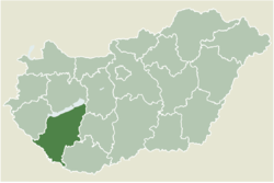 Location of Somogy county in Hungary | |
 Kereki Location of Kereki | |
| Coordinates: 46°47′48″N17°54′44″E / 46.79676°N 17.91215°E | |
| Country | |
| Region | Southern Transdanubia |
| County | Somogy |
| District | Siófok |
| RC Diocese | Kaposvár |
| Area | |
• Total | 14.43 km2 (5.57 sq mi) |
| Population (2017) | |
• Total | 534 [1] |
| • Density | 37.0/km2 (95.8/sq mi) |
| Demonym | Kereki |
| Time zone | UTC+1 (CET) |
| • Summer (DST) | UTC+2 (CEST) |
| Postal code | 8618 |
| Area code | (+36) 84 |
| Patron Saint | Saint Anne |
| Motorways | M7 |
| Distance from Budapest | 125 km (78 mi) Northeast |
| NUTS 3 code | HU232 |
| MP | Mihály Witzmann (Fidesz) |