Austria-Hungary, often referred to as the Austro-Hungarian Empire or the Dual Monarchy, was a multi-national constitutional monarchy in Central Europe between 1867 and 1918. A military and diplomatic alliance, it consisted of two sovereign states with a single monarch who was titled both emperor of Austria and King of Hungary. Austria-Hungary constituted the last phase in the constitutional evolution of the Habsburg monarchy: it was formed with the Austro-Hungarian Compromise of 1867 in the aftermath of the Austro-Prussian War and was dissolved shortly after Hungary terminated the union with Austria on 31 October 1918.

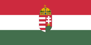
Hungary is a landlocked country in Central Europe. Spanning 93,030 square kilometres (35,920 sq mi) of the Carpathian Basin, it is bordered by Slovakia to the north, Ukraine to the northeast, Romania to the east and southeast, Serbia to the south, Croatia and Slovenia to the southwest, and Austria to the west. Hungary has a population of 9.5 million, mostly ethnic Hungarians and a significant Romani minority. Hungarian, a language belonging to the Ugric branch of the Uralic language family, is the official language, and Budapest is the country's capital and largest city.
The House of Habsburg, also known as the House of Austria, was one of the most prominent and important dynasties in European history.

Hungarian is a Uralic language of the proposed Ugric branch spoken in Hungary and parts of several neighbouring countries. It is the official language of Hungary and one of the 24 official languages of the European Union. Outside Hungary, it is also spoken by Hungarian communities in southern Slovakia, western Ukraine (Transcarpathia), central and western Romania (Transylvania), northern Serbia (Vojvodina), northern Croatia, northeastern Slovenia (Prekmurje), and eastern Austria (Burgenland).

Transylvania is a historical and cultural region in Central Europe, encompassing central Romania. To the east and south its natural border is the Carpathian Mountains and to the west the Apuseni Mountains. Broader definitions of Transylvania also include the western and northwestern Romanian regions of Crișana and Maramureș, and occasionally Banat. Historical Transylvania also includes small parts of neighbouring Western Moldavia and even a small part of south-western neighbouring Bukovina to its north east. The capital of the region is Cluj-Napoca.
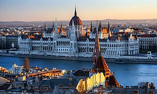
Budapest is the capital and most populous city of Hungary. It is the ninth-largest city in the European Union by population within city limits and it was the largest city on the Danube river; today it is the second largest one. The city has an estimated population of 1,752,286 over a land area of about 525 square kilometres. Budapest, which is both a city and municipality, forms the centre of the Budapest metropolitan area, which has an area of 7,626 square kilometres and a population of 3,303,786. It is a primate city, constituting 33% of the population of Hungary.

Franz Joseph I or Francis Joseph I was Emperor of Austria, King of Hungary, and the ruler of the other states of the Habsburg monarchy from 2 December 1848 until his death in 1916. In the early part of his reign, his realms and territories were referred to as the Austrian Empire, but were reconstituted as the dual monarchy of the Austro-Hungarian Empire in 1867. From 1 May 1850 to 24 August 1866, he was also president of the German Confederation.

The Treaty of Trianon often referred to as the PeaceDictate of Trianon or Dictate of Trianon in Hungary, was prepared at the Paris Peace Conference and was signed on the one side by Hungary and, on the other, by the Entente and Associated Powers in the Grand Trianon château in Versailles on 4 June 1920. It formally terminated the state of war issued from World War I between most of the Allies of World War I and the Kingdom of Hungary. The treaty is mostly famous due to the territorial changes induced on Hungary and recognizing its new international borders after the First World War.
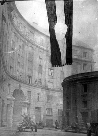
The Hungarian Revolution of 1956, also known as the Hungarian Uprising, was an attempted countrywide revolution against the government of the Hungarian People's Republic (1949–1989) and the policies caused by the government's subordination to the Soviet Union (USSR). The uprising lasted 12 days before being crushed by Soviet tanks and troops on 4 November 1956. Thousands were killed and wounded and nearly a quarter of a million Hungarians fled the country.

Fidesz – Hungarian Civic Alliance is a right-wing populist and national-conservative political party in Hungary led by Viktor Orbán.

The Hungary national football team represents Hungary in men's international football, and is controlled by the Hungarian Football Federation. The team has made nine appearances in the FIFA World Cup, and five in the UEFA European Championship. Hungary plays their home matches at the Puskás Aréna, in Budapest, which opened in November 2019.

Viktor Mihály Orbán is a Hungarian lawyer and politician who has been Prime Minister of Hungary since 2010, previously holding the office from 1998 to 2002. He has led the Fidesz political party since 1993, with a break between 2000 and 2003.

The Kingdom of Hungary was a monarchy in Central Europe that existed for nearly a millennium, from the Middle Ages into the 20th century. The Principality of Hungary emerged as a Christian kingdom upon the coronation of the first king Stephen I at Esztergom around the year 1000; his family led the monarchy for 300 years. By the 12th century, the kingdom became a European power.

The Habsburg monarchy, also known as Habsburg Empire, or Habsburg Realm, was the collection of empires, kingdoms, duchies, counties and other polities that were ruled by the House of Habsburg. From the 18th century it is also referred to as the Danubian monarchy or the Austrian monarchy.

Gadács is a village in Somogy county, Hungary.

Somogydöröcske is a village in Somogy county, Hungary.

Nágocs is a village in Somogy County, Hungary. Jutom-puszta, Csillag-puszta, Tomé-puszta and Kovászna are all parts of Nágocs.
The Kingdom of Hungary, referred to retrospectively as the Regency and the Horthy era, existed as a country from 1920 to 1946 under the rule of Miklós Horthy, Regent of Hungary, who officially represented the Hungarian monarchy. In reality there was no king, and attempts by King Charles IV to return to the throne shortly before his death were prevented by Horthy.

Hungarians, also known as Magyars, are a Central European nation and an ethnic group native to Hungary and historical Hungarian lands who share a common culture, history, ancestry, and language. The Hungarian language belongs to the Uralic language family, alongside, most notably Finnish and Estonian.