Interior Alaska is the central region of Alaska's territory, roughly bounded by the Alaska Range to the south and the Brooks Range to the north. It is largely wilderness. Mountains include Denali in the Alaska Range, the Wrangell Mountains, and the Ray Mountains. The native people of the interior are Alaskan Athabaskans. The largest city in the interior is Fairbanks, Alaska's second-largest city, in the Tanana Valley. Other towns include North Pole, just southeast of Fairbanks, Eagle, Tok, Glennallen, Delta Junction, Nenana, Anderson, Healy and Cantwell. The interior region has an estimated population of 113,154.

Slovakia is a landlocked Central European country with mountainous regions in the north and flat terrain in the south. During much of the Holocene, Slovakia was much more forested than today. Decline of the forest occurred in as consequence of the Valachian colonization and the development of mining in the territory.
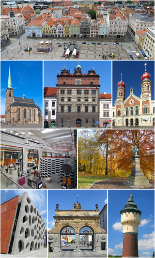
Plzeň, also known in English and German as Pilsen, is a city in the Czech Republic. About 78 kilometres west of Prague in western Bohemia, it is the fourth most populous city in the Czech Republic with about 186,000 inhabitants, and about 323,184 people in its urban area.

Međimurje County is a triangle-shaped county in the northernmost part of Croatia, roughly corresponding to the historical and geographical region of Međimurje. It is the smallest Croatian county by size, as well as the most densely populated. The county's seat and main urban centre is Čakovec.
Miercurea Ciuc is the county seat of Harghita County, Romania. It lies in the Székely Land, a mainly Hungarian-speaking ethno-cultural region in eastern Transylvania, and is situated in the Olt River valley.

Ain Salah, officially Aïn Salah, is an oasis town in central Algeria and the capital of In Salah Province and In Salah District. It was once an important trade link in the trans-Saharan caravan route. As of the 2008 census, it had a population of 32,518, up from 28,022 in 1998, with an annual growth rate of 1.5%, the lowest in the province. The village is located in the heart of the Sahara in North Africa. The name In Salah means "good well".

Bogdanci is a small town in North Macedonia, close to the border with Greece. It is located at around 41°12′11″N22°34′32″E, and is the seat of Bogdanci Municipality.

Hévíz is a spa town in Zala County, Hungary, about 8 kilometres from the city of Keszthely.

Dumbrăvița is a commune in Timiș County, Romania. It is composed of a single village, Dumbrăvița. One of the most developed and rich communes in Romania, Dumbrăvița has become in recent years a suburb of Timișoara.

Kulcs is a village in Fejér county, Hungary

Ciacova is a town in Timiș County, Romania. It administers four villages: Cebza, Macedonia, Obad and Petroman. When it was declared a town in 2004, the villages of Gad and Ghilad, which it administered up to that point, were split off to form Ghilad commune.

Uxem is a commune in the Nord department in northern France.

Cociuba Mare is a commune in Bihor County, Crișana, Romania with a population of 2,798 people. It is composed of four villages: Cărăsău (Karaszó), Cheșa (Kisháza), Cociuba Mare and Petid (Petegd).
Bucovăț is a commune in Timiș County, Romania. It is composed of two villages, Bazoșu Nou and Bucovăț. Part of the commune of Remetea Mare until 2007, it was established as a separate commune in that year.

Gavojdia is a commune in Timiș County, Romania. It is composed of four villages: Gavojdia, Jena, Lugojel and Sălbăgel.

The climate of Hungary is characterized by its position. Hungary is in the eastern part of Central Europe, roughly equidistant from the Equator and the North Pole, more than 1,000 kilometres (600 mi) from both and about 1,000 kilometres from the Atlantic Ocean.

Hercegkút is a village in Borsod-Abaúj-Zemplén County in northeastern Hungary. Swabians— German immigrants — from the Black Forest (Schwarzwald) region of Germany settled here and played a major role in the evolution of the village’s viticulture. The cellars of Gombos Hill and Kőporos are UNESCO World Heritage Sites.

Szentistvánbaksa is a village in the middle of Borsod-Abaúj-Zemplén County in northeastern Hungary, in short Baksa. It stands in a hilly area in the valley of the river Hernád, immediately south of Nagykinisz, between the Main roads 3 and 37, northeast of Miskolc and Szikszó, and northwest of Szerencs and Megyaszó.
Kagganagi is a village in Belgaum district in Karnataka, India.

Hassanabad is a naturally beautiful and far flung village existed in Sub-Division Chorbat, Ghangche District of Gilgit-Baltistan, Pakistan, lying 141 kilometres (88 mi) east of Skardu, near the border of India. The village has 270 households and seven Mohallas. The village is backward in all spheres of life.