Potony

Last updated
Potony
Potonja(in Croatian)
Village
HUN Potony COA.svg
SomogyMegye.png
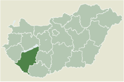
Location of Somogy county in Hungary
Hungary location map.svg
Red pog.svg
Potony
Location of Potony
Coordinates: 45°55′49″N17°39′02″E / 45.93033°N 17.65060°E / 45.93033; 17.65060
Country Flag of Hungary.svg  Hungary
Region Southern Transdanubia
County Somogy
District Barcs
RC Diocese Pécs [1]
Area
  Total
15.9 km2 (6.1 sq mi)
Population
 (2017)
  Total
176 [2]
  Density11.1/km2 (28.7/sq mi)
Demonym potonyi
Time zone UTC+1 (CET)
  Summer (DST) UTC+2 (CEST)
Postal code
7977
Area code (+36) 82
NUTS 3 code HU232
MP László Szászfalvi (KDNP)

Potony (Croatian : Potonja) is a village in Somogy County, Hungary.

Contents

Geography

It lies east of Barcs, 4 km (2.5 mi) from the River Drava, on the border of Somogy and Baranya County. Neighboring villages are Kastélyosdombó, Lakócsa, Tótújfalu and Drávagárdony. The EuroVelo international cycling 13th Vasfüggöny trail runs through the settlement.

History

Potony was first mentioned in the papal tithe register between 1332 and 1337 and already had its own parish. In 1376 it appeared as Poton, in 1403 as Szent-Pál Valley in official documents. There was also another village, Gerenda which perished after 1660. There were nine peasant families in the village in 1695. From the 18th century it was a possession of the Esterházy family who invited Croatian settlers there at that time from Slavonia. [3] According to the 1772 census the residents of Potony spoke all Croatian. The 1870 census shows that it had 431 Croatian or Serb, 154 Hungarian, 1 German and 1 Slovak resident. The name Potony is since 1909 in use. It had 699 residents, 82% of whom were Croats.

Economy

A 400,000 m3 reservoir is under construction as part of the Old-Drava Program.

Main sights

References