Kisasszond

Last updated
Kisasszond
Gospodince(in Croatian)
Village
Kisasszond.jpg
Sárközy Castle in Kisasszond
HUN Kisasszond COA.svg
SomogyMegye.png
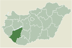
Location of Somogy county in Hungary
Hungary location map.svg
Red pog.svg
Kisasszond
Location of Kisasszond
Coordinates: 46°19′51″N17°38′29″E / 46.330833°N 17.641389°E / 46.330833; 17.641389
Country Flag of Hungary.svg  Hungary
Region Southern Transdanubia
County Somogy
District Kaposvár
RC Diocese Kaposvár
Area
[1]
  Total
7.84 km2 (3.03 sq mi)
Population
 (2017)
  Total
169 [2]
Demonym kisasszondi
Time zone UTC+1 (CET)
  Summer (DST) UTC+2 (CEST)
Postal code
7523
Area code (+36) 82
NUTS 3 code HU232
MP László Szászfalvi (KDNP)

Kisasszond (Croatian : Gospodince) is a village in Somogy county, Hungary.

Contents

Etymology

According to the local legends its name came from the nuns of the monastery that stood there in the Middle Ages. Others state that it got its name from Katalin Bethlen who was the owner of Kisasszond and died as a young girl. The older version of the name of the settlement was Kisasszonyfalva (English: Mistress village). The church of Kisasszond was dedicated to Holy Mary. Kisasszony (English: Mistress) is one of her titles which got a suffix -d like many other settlements in Hungary. [3]

History

According to László Szita the settlement was completely Hungarian in the 18th century. [4]

References

  1. "Kisasszond (Kaposvár, Somogy, Hungary) - Population Statistics, Charts, Map, Location, Weather and Web Information". www.citypopulation.de. Retrieved 2024-10-21.
  2. Kisasszond, KSH
  3. "Lajos Király : Somogyi helységnevek népi és ..." Archived from the original on 2018-05-28. Retrieved 2018-05-27.
  4. László Szita : Somogy megyei nemzetiségek településtörténete a XVIII-XIX. században - Somogyi Almanach 52. (Kaposvár, 1993)