Related Research Articles

Houghton County is a county in the Upper Peninsula in the U.S. state of Michigan. As of the 2020 Census, the population was 37,361. The county seat and largest city is Houghton. Both the county and the city were named for Michigan State geologist and Detroit Mayor Douglass Houghton.

Baraga County is a county in the Upper Peninsula in the U.S. state of Michigan. As of the 2020 Census, the population was 8,158, making it Michigan's fifth-least populous county. The county seat is L'Anse. The county is named after Bishop Frederic Baraga, a Catholic missionary who ministered to the Ojibwa Indians in the Michigan Territory.

Baraga Township is a civil township of Baraga County in the U.S. state of Michigan. As of the 2020 census, the township population was 3,478. The village of Baraga is located in the southeast corner of the township.

L'Anse is a village and the county seat of Baraga County, Michigan. The population was 1,874 at the 2020 census. The village is located within L'Anse Township in the Upper Peninsula, and partially inside the L'Anse Indian Reservation.

L'Anse Township is a civil township of Baraga County in the U.S. state of Michigan. As of the 2020 census, the township population was 3,551. The township contains Mount Arvon and Mount Curwood, Michigans highest and second-highest points, as well as the village of L'Anse.

Spurr Township is a civil township of Baraga County in the U.S. state of Michigan. The population was 262 at the 2020 census.
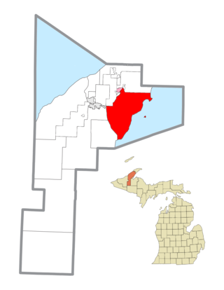
Torch Lake Township is a civil township of Houghton County in the U.S. state of Michigan. As of the 2010 census, the population of the township was 1,880. The township was established in 1886 and is one of the largest townships in Houghton County by area. It is surrounded by the Torch Lake, the Portage Lake, and Lake Superior. As well as a large number of unincorporated communities, the township also includes a portion of the Baraga State Forest which lies along the shores of Keweenaw Bay. The township borders Schoolcraft Township to the north, Osceola Township to the northwest, and Chassell Township to the southwest. The community of Hubbell serves as the major population center of the township, as well as hosting the Township Hall itself. The mostly uninhabited 91-acre Rabbit Island, located offshore in Lake Superior, is a part of the township.

Allouez Township is a civil township of Keweenaw County in the U.S. state of Michigan. The population was 1,340 at the 2020 census.
Grant Township is a civil township of Keweenaw County in the U.S. state of Michigan. The population was 275 at the 2020 census. Grant Township is one of the most isolated municipalities in Michigan, as it forms the tip of the Keweenaw Peninsula, which projects into Lake Superior.

Houghton Township is a civil township of Keweenaw County in the U.S. state of Michigan. The population was 103 at the 2020 census.

The L'Anse Indian Reservation is the land base of the federally recognized Keweenaw Bay Indian Community of the historic Lake Superior Band of Chippewa Indians.. The reservation is located primarily in two non-contiguous sections on either side of the Keweenaw Bay in Baraga County in the Upper Peninsula of the U.S. state of Michigan. The Keweenaw Bay Community also manages the separate Ontonagon Indian Reservation.

M-38 is an east–west state trunkline highway in the Upper Peninsula (UP) of the U.S. state of Michigan. Its west end starts in Ontonagon and runs east to Baraga, some 42.225 miles (67.955 km) apart. The highway crosses streams and rivers in forest lands and provides access to a casino. The east end is located by the Keweenaw Bay of Lake Superior in the Keweenaw Bay Indian Community.

Baraga State Park is a public recreation area covering 56 acres (23 ha) on the shore of Lake Superior's Keweenaw Bay in Baraga County, Michigan. The state park sits along Route 41 on the south side of the village of Baraga. The park, village, and county bear the name of Bishop Frederic Baraga.
Aura is a small unincorporated community in Arvon Township of Baraga County in the U.S. state of Michigan. The area is approximately 12 miles (19 km) northeast of L'Anse and four miles (6 km) east of Pequaming.

Zeba is a census-designated place in L'Anse Township of Baraga County in the U.S. state of Michigan. It is located on the southern shore of Keweenaw Bay at 46°48′09″N88°24′52″W, about halfway between L'Anse and Pequaming. The community was named Zeba because of a small stream that runs southeast of it. The 2010 census recorded a population of 480 inhabitants.

Keweenaw Bay is an arm of Lake Superior in North America. It is located adjacent to the Upper Peninsula of the U.S. state of Michigan, to the southeast of the Keweenaw Peninsula. Keweenaw Bay is 22 miles long and 12 miles wide at the mouth. The head of the bay sits within the reservation of the Keweenaw Bay Indian Community. It is also the name of a small community near the bay.

US Highway 41 (US 41) is a part of the United States Numbered Highway System that runs from Miami, Florida, to the Upper Peninsula of the US state of Michigan. In Michigan, it is a state trunkline highway that enters the state via the Interstate Bridge between Marinette, Wisconsin, and Menominee, Michigan. The 278.769 miles (448.635 km) of US 41 that lie within Michigan serve as a major conduit. Most of the highway is listed on the National Highway System. Various sections are rural two-lane highway, urbanized four-lane divided expressway and the Copper Country Trail National Scenic Byway. The northernmost community along the highway is Copper Harbor at the tip of the Keweenaw Peninsula. The trunkline ends at a cul-de-sac east of Fort Wilkins State Park after serving the Central Upper Peninsula and Copper Country regions of Michigan.

Sturgeon River may refer to any of the following streams in the U.S. state of Michigan:
Sturgeon River is a 106-mile-long (171 km) river in Baraga County and Houghton counties in the U.S. state of Michigan. 25.0 miles (40.2 km) of the river were added to the National Wild and Scenic Rivers System in 1992.
Klingville is a populated place in Chassell Township within southeastern Houghton County in the US state of Michigan.
References
- ↑ U.S. Geological Survey Geographic Names Information System: Keweenaw Bay, Michigan
- ↑ Michigan Atlas & Gazetteer, DeLorme, 15th ed., 2015, p. 23 ISBN 0899334423
- ↑ Romig, Walter (1986) [1973]. Michigan Place Names. Detroit: Wayne State University Press. p. 195. ISBN 0-8143-1838-X.
- ↑ U.S. Geological Survey Geographic Names Information System: Keweenaw Bay Post Office (historical)
46°51′37″N88°28′54″W / 46.86028°N 88.48167°W
Municipalities and communities of Baraga County, Michigan, United States | ||
|---|---|---|
| Villages |  | |
| Civil townships | ||
| CDPs | ||
| Other communities | ||
| Indian reservations | ||
| Footnotes | ‡This populated place also has portions in an adjacent county or counties | |
| Central cities | |
|---|---|
| Counties | |
| Geography | |
| Transportation | |
| Economy | |