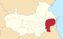
The Dagestan Oblast was a province (oblast) of the Caucasus Viceroyalty of the Russian Empire. It roughly corresponded to most of present-day southeastern Dagestan within the Russian Federation. The Dagestan oblast was created in 1860 out of the territories of the former Caucasian Imamate, bordering the Terek Oblast to the north, the Tiflis Governorate and Zakatal Okrug to the west, the Elizavetpol Governorate to the south, and Baku Governorate to the east. The administrative center of the oblast was Temir-Khan-Shura.

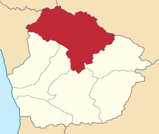
The Terek Oblast was a province (oblast) of the Caucasus Viceroyalty of the Russian Empire, roughly corresponding to the central part of Russia's North Caucasian Federal District. Тhe оblast was created out of the former territories of the North Caucasian Peoples, following their conquests by Russia throughout the 19th century. The Terek Oblast bordered the Astrakhan and Stavropol governorates to the north, the Kuban Oblast to the west, the Kutaisi and Tiflis governorates to the south, and the Dagestan Oblast to the east. The administrative center of the oblast was Vladikavkaz, the current capital of North Ossetia–Alania within Russia.

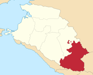
The Zakatal okrug was a special administrative district (okrug) of the Caucasus Viceroyalty of the Russian Empire, part of the Tiflis Governorate from 1893 to 1905. The administrative centre of the district was Zakataly, and it corresponded to most of the contemporary districts of Balakan, Zaqatala and Qax of Azerbaijan. The Zakatal okrug was established from the territories of the erstwhile Free Jamaats of Jar-Balakan, bordering the Tiflis Governorate to the west, the Elizavetpol Governorate to the south and the Dagestan Oblast to the north. The district was the smallest independent administrative unit of the Russian Empire, similarly to the Sukhumi okrug.
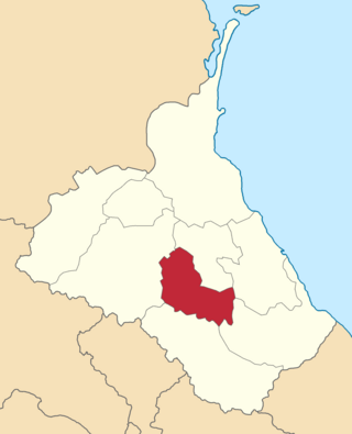
The Lechkhumi uezd was a county (uezd) of the Kutaisi Governorate of the Caucasus Viceroyalty of the Russian Empire. It bordered the Terek and Kuban oblasts to the north, the Sukhumi Okrug to the west, the Zugdidi, Senaki, and Kutais uezds to the south and the Racha uezd to the east. The area of the uezd corresponded to most of the contemporary Samegrelo-Zemo Svaneti region of Georgia. The administrative center of the Lechkhumi uezd was the town of Tsageri.
The Batalpashinsky otdel was a Cossack district of the Kuban oblast of the Caucasus Viceroyalty of the Russian Empire. It bordered the Stavropol Governorate to the north, the Labinsky and Maykopsky otdels to the west, the Sochi and Sukhumi okrugs to the south, and the Terek Oblast to the east. The area of the Batalpashinsky otdel included most of the contemporary Karachay-Cherkessia region of Russia. The administrative capital was the city of Batalpashinskaya.

The Avarskiy okrug was a district (okrug) of the Dagestan Oblast of the Caucasus Viceroyalty of the Russian Empire. The area of the Avarskiy okrug is included in contemporary Dagestan of the Russian Federation. The district's administrative centre was Khunzakh.

The Andiyskiy okrug was a district (okrug) of the Dagestan Oblast of the Caucasus Viceroyalty of the Russian Empire. The area of the Andiyskiy okrug is included in contemporary Dagestan of the Russian Federation. The district's administrative centre was Botlikh.

The Gunibskiy okrug was a district (okrug) of the Dagestan Oblast of the Caucasus Viceroyalty of the Russian Empire. The area of the Gunibskiy okrug is included in contemporary Dagestan of the Russian Federation. The district's centre was Gunib.

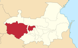
The Darginskiy okrug was a district (okrug) of the Dagestan Oblast of the Caucasus Viceroyalty of the Russian Empire. The area of the Darginskiy okrug is included in contemporary Dagestan of the Russian Federation. The district's administrative centre was Levashi.
The Kazikumukhskiy okrug was a district (okrug) of the Dagestan Oblast of the Caucasus Viceroyalty of the Russian Empire. The area of the Kazikumukhskiy okrug is included in contemporary Dagestan of the Russian Federation. The district's administrative centre was Kumukh.
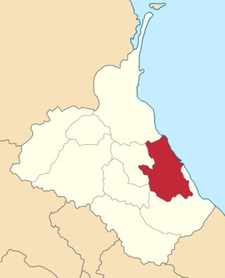
The Kaytago-Tabasaranskiy okrug was a district (okrug) of the Dagestan Oblast of the Caucasus Viceroyalty of the Russian Empire. The area of the Kaytago-Tabasaranskiy okrug is included in contemporary Dagestan of the Russian Federation. The district's administrative centre was Madzhalis.
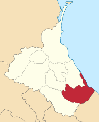
The Kyurinskiy okrug was a district (okrug) of the Dagestan Oblast of the Caucasus Viceroyalty of the Russian Empire. The area of the Kyurinskiy okrug is included in contemporary Dagestan of the Russian Federation. The district's administrative centre was Kasumkent.

The Samurskiy okrug was a district (okrug) of the Dagestan Oblast of the Caucasus Viceroyalty of the Russian Empire. The area of the Samurskiy okrug is included in contemporary Dagestan of the Russian Federation. The district's administrative centre was Akhty.
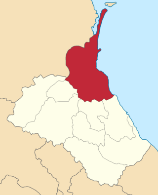
The Temir-Khan-Shurinskiy okrug was a district (okrug) of the Dagestan Oblast of the Caucasus Viceroyalty of the Russian Empire. The area of the Temir-Khan-Shurinskiy okrug is included in contemporary Dagestan of the Russian Federation. The district's administrative centre was Temir-Khan-Shura.

The Vedensky okrug was a district (okrug) of the Terek Oblast of the Caucasus Viceroyalty of the Russian Empire. The area of the Vedensky okrug made up part of the North Caucasian Federal District of Russia. The district was eponymously named for its administrative centre, Vedeno.
The Nalchiksky okrug was a district (okrug) of the Terek Oblast of the Caucasus Viceroyalty of the Russian Empire. The area of the Nalchiksky okrug made up part of the North Caucasian Federal District of Russia. The district was eponymously named for its administrative center, Nalchik.

The Sunzhensky otdel was a Cossack district of the Terek oblast of the Caucasus Viceroyalty of the Russian Empire. The area of the Sunzhensky otdel makes up part of the North Caucasian Federal District of Russia.

The Vladikavkazsky okrug was a district (okrug) of the Terek Oblast of the Caucasus Viceroyalty of the Russian Empire. The area of the Vladikavkazsky okrug made up part of the North Caucasian Federal District of Russia. The district was eponymously named for its administrative centre, Vladikavkaz.

The Groznensky okrug was a district (okrug) of the Terek Oblast of the Caucasus Viceroyalty of the Russian Empire. The area of the Groznensky okrug made up part of the North Caucasian Federal District of Russia. The district was eponymously named for its administrative centre, Grozny.

The Kizlyarsky otdel was a Cossack district of the Terek oblast of the Caucasus Viceroyalty of the Russian Empire. The area of the Kizlyarsky otdel makes up part of the North Caucasian Federal District of Russia. The district was eponymously named for its administrative center, Kizlyar.