
India is the most populous country in the world with one-sixth of the world's population. According to estimates from the United Nations (UN), India has overtaken China as the country with the largest population in the world, with a population of 1,425,775,850 at the end of April 2023.

Balussery is a town located about 25 km northeast of Kozhikode city, situated on State Highway 34. It is one of the 12 block Panchayats in the Kozhikode district and serves as the northeastern entry point to Kozhikode city.
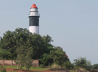
Koyilandy is a major town municipality and a taluk in Kozhikode district, Kerala on the Malabar Coast. The historical town is located right in the middle of the coast of Kozhikode district, between Kozhikode and Kannur, on National Highway 66.
Poonoor is a town in Kozhikode District, Kerala, India. The town is part of the Unnikulam Panchayath, within the Thamarassery Taluk of the Kozhikode District. Poonoor can be found on the banks of the Poonoor River 4.5 km west of Thamarassery and 8.5 km east of Balussery. The town is situated on Koyilandy-Edavanna Road State Highway 34 that starts in Koyilandy and ends in Edavanna.

Perambra is a major town in Koyilandy taluk of Kozhikode district in North Malabar region of Kerala state, India. It is one of the 140 assembly constituencies in Kerala, and one of the 12 block Panchayats in Kozhikode district. Perambra lies almost at the centre of the district. The area which was formerly known as Payyormalanadu, eventually became Perambra. In the Northern Songs, there are references to the Payyormalanadu of Old Kurumbranadu.
Vattoli Bazaar is a suburb of Balussery. It situated 2 km east of Balussery town in the Koyilandy -Thamarassery state highway. The location is in Kozhikode district of Kerala state in India.

Kokkallur is a suburb of Balussery. In 2015 was the name of a ward in Balussery Panchyat in Kozhikode district, State of Kerala, India. People of this area earns their lives by farming. A higher secondary school, village office, Gramin Bank, and telephone exchange are the main government establishments. When India was under British power, Kachery of British Police was situated near by area. This Kachery was burnt by freedom fighters in freedom struggle movement. This place is now known as Kachery kunnu.
Naduvannur is a Grama Panchayath and a Census town in Kozhikode district in the state of Kerala, India. It lies at the center of the district. Naduvannur is part of Kozhikode Urban Agglomeration. The name Naduvannur denotes that it was the center of the territory of Kurumbranad. 'Nadu' means center and ur(oor) means place.

Nanminda is a suburb of Balussery. It situated 2.8 km from Balussery town.It is a village in Kozhikode district in the state of Kerala, India. Nanminda is also written as "Nanmanda".
Ulliyeri is a village in Kozhikode district in the state of Kerala, India. Ulliyeri is between Koyilandy and Balussery and also between Kuttiyadi and Kozhikode.
Koyilandy is a major town municipality and a taluk in Kozhikode district, Kerala on the Malabar Coast. The historical town is located right in the middle of the coast of Kozhikode district, between Kozhikode and Kannur, on National Highway 66.

Koduvally is a major municipal town in Kozhikode district in the Indian state of Kerala. It is located on the National Highway 766 and is about 21 km northeast of Kozhikode (Calicut) city. koduvally is known as the city of gold for its gold trade legacy since 18s and 19s. Koduvally is one of the 140 assembly constituencies in Kerala and One of the 12 block panchayats in kozhikode.The nearest local bodies are Kizhakkoth, Madavoor, kunnamangalam, Omassery, Mukkam, and Thamarassery. Koduvally also gives its name to the Koduvally River which flows west into the sea.
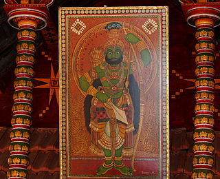
Vettakkoru Makan is a Hindu deity worshipped in parts of Northern Kerala. This deity is alternately referred as Kiratha-Sunu in Sanskrit. Vettakkorumakan is believed to be the son of Shiva by his consort Parvati, born when he assumed the form of a Kirata (hunter) to deliver a weapon known as Pashupatastra to Arjuna. He is mostly and exclusively worshipped in Malabar region of Kerala. The most famous temple of this deity is the Balussery-Kotta Vettakkorumakan temple about 25 km from Calicut. This was once the fort of the Rajas of Kurumbranad. Other prominent temples are at Ramanthali, Nileshwar, Kottakkal, Nilambur, Karaparamba and various places in Kannur district and Kasargod district. He is the family deity of the Rajas of Chirakkal, Nileshwar, Kottakkal, Nilambur Kovilakam, Kalathil Kartha's, Aluva, Amarambalam Kovilakam and Randu Illam Vargam Nambiars. Those families among the nobility of Malabar who have Vettakkorumakan as their family deity are connected in one way or other incidentally to either Balussery Fort or Kurumbranad.Later he moved to Kottanachery temple in Vellur, Payyanur in North Malabar. A special type of firecracker called "Kathina" was his favourite.
Panangad is a suburb of Balussery in Kozhikode district. It is one among the 75 grama panchayats and coming under Balussery block.

Ezhamathe Varavu is a 2013 Malayalam drama thriller film written by M. T. Vasudevan Nair and directed by Hariharan. The film stars Indrajith, Vineeth, Bhavana, and Kavitha in the lead roles while Mamukkoya and Nandhu play pivotal supporting roles. The music was composed by the director himself who also produced the film under the banner of Gayatri Cinema Enterprises.
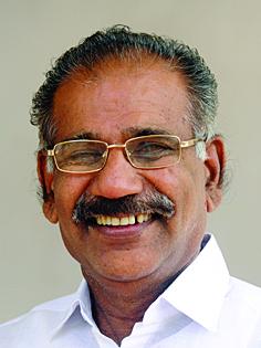
A. K. Saseendran is an Indian politician who has served as the Minister for Forests and Wildlife Protection of Kerala since 2021. He previously served as the Minister for Transport of Kerala from 2018 to 2021 and from 2016 to 2017. He is a Member of the Kerala Legislative Assembly representing Elathur since 2011. He previously represented Peringalam from 1980 to 1982, Edakkad from 1982 to 1987 and Balussery from 2006 to 2011 in the Kerala Legislative Assembly. He is a member of the Nationalist Congress Party.

Jammu and Kashmir is a region administered by India as a union territory and consists of the southern portion of the larger Kashmir region, which has been the subject of a dispute between India and Pakistan since 1947 and between India and China since 1959. The Line of Control separates Jammu and Kashmir from the Pakistani-administered territories of Azad Kashmir and Gilgit-Baltistan in the west and north. It lies to the north of the Indian states of Himachal Pradesh and Punjab and to the west of Ladakh which is administered by India as a union territory.

K. M. Sachin Dev is an Indian politician from Kerala. He is the member of Kerala Legislative Assembly from Balussery constituency, since May 2021. He is the youngest MLA in 15th Kerala Legislative Assembly. He was the State Secretary of Students' Federation of India, Kerala State Committee.

