The Coming Street Cemetery is located at 189 Coming Street, in Charleston, South Carolina. This Jewish cemetery, one of the oldest in the United States was founded in 1762 by Sephardi Jews and is the oldest Jewish burial ground in the South. Burials in the Coming Street Cemetery are now restricted to the few vacancies in the adjacent family plots. The cemetery was listed on the National Register of Historic Places in 1996.

The Huguenot Church, also called the French Huguenot Church or the French Protestant Church, is a Gothic Revival church located at 136 Church Street in Charleston, South Carolina. Built in 1844 and designed by architect Edward Brickell White, it is the oldest Gothic Revival church in South Carolina, and has been designated a National Historic Landmark and listed on the National Register of Historic Places. The congregation it serves traces its origins to the 1680s, and is the only independent Huguenot church in the United States.

Magnolia Cemetery is a historic cemetery in Charleston, South Carolina. It was dedicated in 1850; Charles Fraser delivered the dedication address. It was listed on the National Register of Historic Places as a Historic District in 1978.

Cook's Old Field Cemetery, also known as Hamlin Cemetery, is a historic cemetery located near Mount Pleasant, Charleston County, South Carolina. It contains graves dating from 1805 to 1916; the majority date from the 1840s and 1850s. The oldest marker is for Arnold Wells who died in 1805. On July 16, 1863, Mary Moore Hamlin set aside one acre of land for the dedicated cemetery.
Spratt Cemetery is a historic family cemetery located near Fort Mill, York County, South Carolina. It contains graves of three generations of the Spratt family, and other early settlers of the Fort Mill area. The cemetery consists of 14 marked graves and approximately 9 graves with broken stones or partial markers. It includes the grave of Thomas "Kanawha" Spratt, one of the first settlers of the area, and located adjacent to the site his homestead along Nation Ford Road. The land was provided for the Spratt homestead by the General New River, leader of the Catawba tribe.
Ashley Hall Plantation is a historic plantation complex located on the Ashley River near West Ashley, Charleston County, South Carolina. The plantation was established in the early 1670s by Stephen Bull. The property includes a small tabby-walled house with a 20th-century second story addition, the ruins of the Georgian plantation house (1704) which was burned in 1865 to prevent its destruction by Union forces, a monument to the second Governor William Bull, two prehistoric Indian archaeological sites, and two 18th century well sites associated with the plantation. The tabby house is considered one of the oldest standing houses in the state.
Auld Mound (38CH41), also known as Yough Hall Plantation Shell Ring, is a historic mound located near Mount Pleasant, Charleston County, South Carolina. It is one of 20 or more prehistoric shell rings located from the central coast of South Carolina to the central coast of Georgia. On average, it measures 174 feet in diameter and stands 2 to 3 feet high. The midden is largely composed of oyster shell.
Buzzard's Island Site is a historic mound located near Mount Pleasant, Charleston County, South Carolina. It is one of 20 or more prehistoric shell rings located from the central coast of South Carolina to the central coast of Georgia. On average, it measures 178 feet in diameter and stands 3 feet high. The midden is largely composed of oyster shell.

Sewee Mound (38CH45), also known as the Old Fort, is a historic mound located near Awendaw, Charleston County, South Carolina. It is one of 20 or more prehistoric shell rings located from the central coast of South Carolina to the central coast of Georgia. On average, it measures 149 feet in diameter and stands 10 feet high. The midden is largely composed of oyster shell. A smaller midden is located nearby.
Hanckel Mound (38CH7) is a historic mound located near Rockville, Charleston County, South Carolina. It is one of 20 or more prehistoric shell rings located from the central coast of South Carolina to the central coast of Georgia. On average, it measures 158 feet in diameter and stands 8 feet high. The midden is largely composed of oyster shell.
Horse Island (38CH14) is a historic mound located near Rockville, Charleston County, South Carolina. It is one of 20 or more prehistoric shell rings located from the central coast of South Carolina to the central coast of Georgia. On average, it measures 156 feet in diameter and stands 4 feet high. The midden is largely composed of oyster shell.
Lighthouse Point Shell Ring (38CH12), also known as Parrot's Point Shell Ring, is a historic mound located on James Island, Charleston County, South Carolina. It is one of 20 or more prehistoric shell rings located from the central coast of South Carolina to the central coast of Georgia. The midden contains a diverse array of biota.
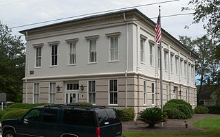
Old Berkeley County Courthouse, also known as Old Courthouse, is a historic courthouse located at Mount Pleasant, Charleston County, South Carolina. It was built in 1884, and is a two-story, rectangular, stucco over brick building in the Late Victorian style. It features large matching double stairways leading to the main entrance on the second floor. The building served as county courthouse for Berkeley County from 1884 to 1898. After 1898 until 1968, it was used by both Baptists and Lutherans as a church. It is now known as the G. Mcgrath Darby Building.
Barnwell House, also known as Prospect Hill Plantation, is a historic home located at Adams Run, Charleston County, South Carolina. It consists of the front or main portion dating from 1878 and the rear section from early to mid-19th century. The main part is a 2 1/2-story building, with a stuccoed brick first story and weatherboarded upper story. The front façade features a one-story portico with a bell cast hip roof supported by two solid Doric order fluted columns.

Willtown Bluff, also known as Wilton and New London, is a historic settlement site located on the S. Edisto River near Adams Run, Charleston County, South Carolina. Founded about 1704, it was the second planned town to be established after the relocation of Charleston in 1682. Willtown served as a local governmental center and regional commercial center. The property includes three early-19th century buildings: the Parsonage, the Willtown Plantation House, and the remains of a single column of the Episcopal church. Unexposed remains are of a colonial village thought to have had 80 houses.
Bass Pond Site (38CH124) is a historic archaeological site located at Kiawah Island, Charleston County, South Carolina. Excavations indicate that at least two separate human occupations are represented: a Formative period settlement and a Middle Woodland settlement. Both of the occupations occur in the shell midden.

Long Point Plantation (38CH321) is a historic plantation site located near Mount Pleasant, Charleston County, South Carolina. The plantation was built sometime between 1719 and 1763, but "comes of age" during the 19th century. The plantation house and structures were probably built prior to 1763. The plantation was purchased by the prominent Venning family in 1800 and was held by that family until 1899. The main house was apparently razed between 1933 and 1943. One small, brick structure is still standing at the site.

Lucas Family Cemetery is a historic plantation cemetery located near Mount Pleasant, Charleston County, South Carolina. It was established in 1825, and the walled plot includes several grave markers signed by Charleston carvers. Eleven gravemarkers remain, dating from 1825 to 1892, and five are brick box tombs with slab or table tops.

Secessionville Historic District is a national historic district located near Folly Beach, Charleston County, South Carolina. It extends into the city of Charleston, South Carolina. The district encompasses six contributing buildings, one contributing site, and one contributing site in Secessionville. The district includes the summer homes of several leading James Island planters, the site of the American Civil War Battle of Secessionville, the unmarked grave of over 300 Union soldiers, and the remains of Fort Lamar, constructed about 1862.