
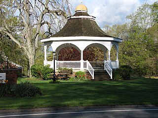
Brookfield is a town in Fairfield County, Connecticut, United States, situated within the southern foothills of the Berkshire Mountains. The population was 17,528 at the 2020 census. The town is located 55 miles (89 km) northeast of New York City, making it part of the New York-Newark, NY-NJ-CT-PA combined statistical area. The town is part of the Western Connecticut Planning Region. In July 2013, Money magazine ranked Brookfield the 26th-best place to live in the United States, and the best place to live in Connecticut.

Fairfield County is a county in the southwestern corner of the U.S. state of Connecticut. It is the most populous county in the state and was also its fastest-growing from 2010 to 2020. As of the 2020 census, the county's population was 957,419, representing 26.6% of Connecticut's overall population. The closest to the center of the New York metropolitan area, the county contains four of the state's seven largest cities—Bridgeport (first), Stamford (second), Norwalk (sixth) and Danbury (seventh)—whose combined population of 433,368 is nearly half the county's total population.
Monroe is a town located in eastern Fairfield County, Connecticut, United States. The population was 18,825 at the 2020 census. The town is part of the Greater Bridgeport Planning Region.

Wilton is a town in Fairfield County, Connecticut, United States. As of the 2020 census, the town population was 18,503. The town is part of the Western Connecticut Planning Region.
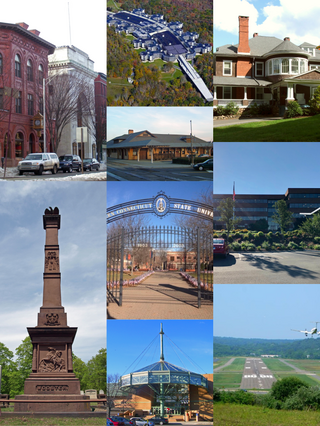
Danbury is a city in Fairfield County, Connecticut, United States, located approximately 50 miles (80 km) northeast of New York City. Danbury's population as of 2020 was 86,518. It is the third-largest city in Western Connecticut, and the seventh-largest city in Connecticut. Located within the heart of the Housatonic Valley region, the city is a commercial hub of western Connecticut, an outer-ring commuter suburb of New York City, and an historic summer colony of the New York metropolitan area and New England.

Trumbull is a town located in Fairfield County, Connecticut, United States. The town is part of the Greater Bridgeport Planning Region, and borders on the cities of Bridgeport and Shelton, as well as the towns of Stratford, Fairfield, Easton and Monroe. The population was 36,827 during the 2020 census. The Trumbull area was the home of the Golden Hill Paugussett Indian Nation for thousands of years before the English settlement was made in 1639.

New Milford is a town in Litchfield County, Connecticut, United States. The town, part of Greater Danbury, as well as the New York Metropolitan Area, has a population of 28,115 as of the 2020 census. New Milford lies 14 miles (23 km) north of Danbury on the banks of the Housatonic River, and shares its border with the northeastern shore of Candlewood Lake. It is the largest town in the state of Connecticut in terms of land area at nearly 63.7 mi2 (164.9822 km2). The town center is listed as a census-designated place (CDP).

The Diocese of Bridgeport is a Latin Church ecclesiastical jurisdiction or diocese of the Catholic Church located in the southwestern part of the state of Connecticut in the United States. It is a suffragan diocese in the ecclesiastical province of the metropolitan Archdiocese of Hartford.
New Fairfield High School is the only public high school in New Fairfield, Connecticut, United States. It enrolls approximately 500 to 700 students annually in grades 9-12 from New Fairfield, as well as students from the neighboring town of Sherman who elect to attend. James D'Amico was named principal of New Fairfield High School in 2019.

The News-Times is a daily newspaper based in Danbury, Connecticut, United States. It is owned and operated by the Hearst Corporation.

The Main Street Historic District in Danbury, Connecticut, United States, is the oldest section of that city, at its geographical center. It has long been the city's commercial core and downtown. Its 132 buildings, 97 of which are considered contributing properties, include government buildings, churches, commercial establishments and residences, all in a variety of architectural styles from the late 18th century to the early 20th. It is the only major industrial downtown of its size in Connecticut not to have developed around either port facilities or a water power site.
Bridgeport is the most populous city in the U.S. state of Connecticut and the fifth-most populous city in New England, with a population of 148,654 in 2020. Located in eastern Fairfield County at the mouth of the Pequonnock River on Long Island Sound, it is a port city 60 miles (97 km) from Manhattan and 40 miles (64 km) from The Bronx. It borders the towns of Trumbull to the north, Fairfield to the west, and Stratford to the east. Bridgeport and other towns in Fairfield County make up the Greater Bridgeport Planning Region, as well as the Bridgeport–Stamford–Norwalk–Danbury metropolitan statistical area, the second largest metropolitan area in Connecticut. The Bridgeport–Stamford–Norwalk–Danbury metropolis forms part of the New York metropolitan area.
St. Gregory the Great is a Roman Catholic church in Danbury, Connecticut, United States, part of the Diocese of Bridgeport.

St. Peter is a Roman Catholic church in Danbury, Connecticut, part of the Diocese of Bridgeport. St. Peter's was the first Catholic church built in northern Fairfield County. It is the third oldest parish, and the fifth oldest Roman Catholic Church in the Diocese of Bridgeport. St. Peter's was originally a predominantly Irish congregation. Danbury's Annual St. Patrick's Day Parade steps off in front of St. Peter's. In more recent time, the parish has a significant number of parishioners of Latino and Brazilian heritage.

English Avenue and Vine City are two adjacent and closely linked neighborhoods of Atlanta, Georgia. Together the neighborhoods make up neighborhood planning unit L. The two neighborhoods are frequently cited together in reference to shared problems and to shared redevelopment schemes and revitalization plans.
Henry Christian Spencer was an American businessman and executive at the Kerite Company in Seymour, Connecticut. As secretary and vice president, he was involved in discussions about unions at the company, and in its joining with Hubbell Company.

Miry Brook is an unincorporated area in the City of Danbury in Fairfield County, Connecticut. It is located in the western part of the city, bordering Mill Plain to the north and west at Lake Kenosia and the town of Ridgefield, Connecticut, to the southwest. The Danbury Airport is located in Miry Brook.

Great Plain is an unincorporated area in the City of Danbury, Fairfield County, Connecticut. A former farming community, only remnants exist of this once thriving agricultural hub. It is located in the northeast section of the city, sharing a border with the Beaverbrook area of Danbury and Brookfield, CT.

Northville is a unincorporated area in the town of New Milford, Litchfield County, Connecticut, United States. It is located approximately 4 miles (6.4 km) northeast of New Milford Town Center along U.S. Route 202.

Hayestown is an unincorporated area in Danbury, Connecticut. It is located in the eastern section of the city, along the southern shoreline of Candlewood Lake, west of Great Plain, northwest of Germantown, and east of Clapboard Ridge.


