Kingston, Nevada | |
|---|---|
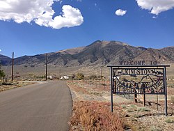 Entrance to Kingston from Nevada State Route 376. Bunker Hill is visible in the background. | |
 Kingston Location of Kingston, Nevada | |
| Coordinates: 39°12′36″N117°04′05″W / 39.21000°N 117.06806°W | |
| Country | United States |
| State | Nevada |
| Area | |
• Total | 4.07 sq mi (10.54 km2) |
| • Land | 4.07 sq mi (10.54 km2) |
| • Water | 0.00 sq mi (0.00 km2) |
| Elevation | 5,955 ft (1,815 m) |
| Population (2020) | |
• Total | 194 |
| • Density | 47.69/sq mi (18.41/km2) |
| Time zone | UTC-8 (Pacific (PST)) |
| • Summer (DST) | UTC-7 (PDT) |
| ZIP code | 89310 |
| Area code | 775 |
| FIPS code | 32-38100 |
| GNIS feature ID | 2583936 [2] |
Kingston is an unincorporated town and census-designated place in Lander County, Nevada, United States. [3] The population of the census-designated place of Kingston was 113 at the 2010 census. [4]
