Kitchanga | |
---|---|
Location in the Congo | |
Coordinates: 01°15′8″S29°3′32″E / 1.25222°S 29.05889°E | |
Country | DR Congo |
Province | North Kivu |
Territory | Masisi and Rutshuru |
Chiefdom | Bashali |
Population (2015) | |
• Total | 18,927 for the Masisi Territory and 25,157 Rutshuru Territory |
Time zone | UTC+2 (CAT) |
Official language | French |
National language | Swahili |
Climate | Aw |
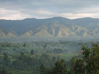
Kitchanga, also known as Kitshanga, is a town and a camp for Congolese Internally Displaced People (IDPs) strategically positioned between Masisi and Rutshuru territories of the North Kivu Province, with a vantage point overlooking Lake Kivu in the eastern region of the Democratic Republic of the Congo (DRC). [1] [2] Administratively, the Masisi part of Kitchanga functions as a larger urban center and the capital of the Bashali Chiefdom, [3] [4] [5] [6] while the other part is situated in the Bwito Chiefdom of the Rutshuru Territory. [7] Geographically, Kitchanga is located approximately 90 km northwest of Goma and 10 kilometers north of Burungu, in close proximity to the villages of Kizimba and Budey. [3] [8] [9] As of 2015, the population of Kitchanga was estimated at 18,927 for the Masisi Territory part and 25,157 for the Rutshuru Territory, excluding the populace within the displaced sites of Kahe and Mungote adjacent to Kitchanga in the Masisi Territory. [10]
During the 1990s, Kitchanga experienced a rapid demographic surge. The region's infrastructure evolved with the construction of wooden, brick, and multi-storey houses, coupled with the development of roads, utilities, and a diversified local economy comprising various commercial enterprises, positioning Kitchanga as one of eastern DRC's burgeoning cities and boomtowns. [11] The predominant economic activity is subsistence agriculture, with local agrarians producing crops such as maize, beans, potatoes, and assorted vegetables. [1] [12] [13] [14] Animal husbandry also constitutes a pivotal component of the local economy. It provides a source of income along with dairy products, meat, and ancillary by-products for local consumption and commerce. [15] [16] [17] Kitchanga also hosts various service-oriented businesses, including healthcare facilities, [18] [19] educational institutions, [20] [21] and hospitality establishments. [22] [23]
Since the First Congo War, Kitchanga has been affected by the protracted conflict that has engulfed the region, becoming a site of violence and mass displacement. [24] [25] [26] [27] On 20 November 2012, the M23 rebel military group seized control over significant portions of North Kivu Province, eventually capturing the provincial capital of Goma. [28] [29] The M23's reign was characterized by widespread human rights abuses, including the conscription of child soldiers, sexual violence against women and girls, and the forced displacement of civilians. Consequently, Kitchanga has become a shelter for those fleeing violence while concurrently functioning as a contested town, a rebel stronghold, and combat zone. [1] [30] [31] [32]
Kitchanga was traditionally inhabited by the Hunde people. During the era of Belgian colonial rule, the Hunde community was organized into their newly-established self-governing entity known as the "Hunde Chiefdom," presided over by a traditional chief who enforced colonial law and order. [33] [34] This establishment of localized governance fostered a semblance of self-governance while ensuring the stringent implementation of colonial mandates. [33]
In the 1930s, Belgian colonial administration planned and organized a migratory movement of labor from neighboring Rwanda towards eastern part of then Belgian Congo. [35] [36] The territory of Ruanda-Urundi, having been annexed as a protectorate under Belgian colonial rule, housed a dense populace, whereas the Belgian Congo, also under Belgian jurisdiction, encompassed regions marked by notably sparse population densities. [35] [36] The Belgian colonists favored the proclivity for the influx of these Banyarwanda transplanted laborers and migrants seeking sanctuary in the eastern precincts of the Belgian Congo as the local populations had vacated due to the forced labor imposed by white farmers. The Banyarwanda, primarily settled in strategic locations such as Masisi Territory in present-day North Kivu Province, Itombwe in present-day South Kivu Province, and the Vyura Mountains above Moba in Katanga Province, were seen as a solution to the labor shortages. [35] [36]
To accommodate the Banyarwanda immigrants, the Belgian colonizers instituted "atypical chefferies [chiefdoms]" for Banyarwanda, including the establishment of the Bwisha Chiefdom and Gishari Chiefdom. These territories, covering an expanse of 34,910 hectares (350 km2), were procured by colonial authorities through duress in 1939 from the Bahunde chieftains, with the intent of providing habitation for Banyarwanda immigrants. In 1938, Mr. Leenaerts, a Belgian administrator transplanted from Ruanda-Urundi, made his way to the region with the charge of overseeing the welfare of the immigrants he had previously supervised in Rwanda. [37] [38] [39] [33] After his visit, he was eventually succeeded by Chief Bideri from Rwanda, who, in turn, was replaced in 1941 by another Rwandan chief named Buchanayandi. The establishment of these chieftaincies and the appointment of Rwandan immigrants as traditional chiefs incited ethnic conflicts between the Banyarwanda immigrants and the Hundes, with the latter asserting their ancestral claims to the land. In 1957, the Hundes regained control of Gishari, merging it into the Bahunde Chiefdom. [39] [40] [37] [41] Administrative reorganizations culminated in December 1977 with the formation of the modern Bashali Chiefdom. [42] The abolition of this chiefdom left the Banyarwanda of Masisi Territory devoid of customary authority, significantly impacting their political representation and contributing to the ongoing struggle for political inclusion of Rwandophone speakers in Masisi Territory. [43]
Following Congo's independence, local tensions flared into conflict between 1963 and 1965 during the local elections, resulting in the Kanyarwanda War. At this time, Kitchanga was primarily inhabited by laborers on the plantations and was a small village serving travelers between Goma and larger centers like Pinga, Mweso, and Birambizo. [43] Despite its modest size, Kitchanga had significant commercial importance due to its strategic location at the junction of several transport routes. [43] The early 1990s saw a resurgence of ethnic conflict in Masisi. Populations identifying as "indigenous," such as Hunde, Nyanga, and Tembo, collided with those they referred to as non-indigenous Rwandophones, predominantly Hutu. [43] Local ethnic militias were formed, and the violent clashes, exacerbated by the weakening of Mobutu Sese Seko's regime, resulted in approximately 10,000 deaths and the displacement of at least 250,000 people. Many Hunde, including Mwami Sylvestre Bashali, fled to Kitchanga, leading to a significant influx of displaced Hunde people into the town. [43]
The 1994 Rwandan genocide and the subsequent influx of Hutu refugees into eastern Zaire further disrupted the region's political landscape. Around 850,000 refugees, including elements of the Forces Armées Rwandaises (FAR) and the Interahamwe, responsible for the genocide, settled in North Kivu. [43]
By the late 1990s, the refugee crisis and local conflicts intensified, culminating in the First Congo War. The Alliance of Democratic Forces for the Liberation of Congo (AFDL), led by Laurent-Désiré Kabila and supported by Rwanda, overthrew Mobutu in 1997. In North Kivu, the rebellion, often perceived as dominated by Tutsi, gave rise to militias that identified as anti-Tutsi forces. [43] The Second Congo War began in 1998, after Laurent-Désiré Kabila attempted to expel his Rwandan allies, leading to the control of eastern Congo by the rebel movement Congolese Rally for Democracy (RCD), which was supported by Rwanda and Uganda. [43] During the RCD era, Kitchanga remained a refuge. The RCD restructured "customary" authority, replacing local leaders with those aligned with the RCD. For instance, the Mwami of Bashali-Mokoto was replaced by Kapenda Muhima, a notable local Hunde aligned with the RCD. [43] [44]
This period saw political and military elites, mainly Rwandophones Congolese, acquiring vast land concessions through semi-legal and often violent means. Kitchanga became an important site for Congolese Tutsi "returnees" from Rwanda and, as such, gained strategic importance in the RCD's "repatriation policy." Most of these "returnees" established themselves around 2002 in Kahe. This elite participation transformed Kitchanga into a major urban center. Kitchanga increasingly became a "place of refuge," attracting displaced people from various ethnic backgrounds. [43]
Following the 2002 Pretoria Peace Agreement, the RCD underwent a significant transformation, reconfiguring itself as a political party and actively participating in the political process leading up to subsequent elections. RCD members failed to secure seats during the initial elections in 2006, leaving them without representation in provincial and national politics. Disenchanted by the outcome, a faction of discontented members spearheaded by Laurent Nkunda broke away from the RCD and formed the National Congress for the Defense of the People (CNDP), later re-established as M23 to preserve their influence in Kinshasa and safeguard their economic and security prerogatives in the eastern regions. [45] [1]
In November 2012, M23 rebels clashed with the Armed Forces of the Democratic Republic of the Congo (FARDC), subsequently establishing control over extensive swathes of North Kivu, including pivotal areas such as Goma. [28] On November 21, 2012, M23 forces advanced on Sake, securing the Kirolirwe axis en route to Kitchanga. [46] In response, the United Nations Organization Stabilization Mission in the Democratic Republic of the Congo (MONUSCO) deployed "robust patrols" to protect civilians and counter the M23 and Alliance of Patriots for a Free and Sovereign Congo (APCLS) militias towards their base in Kitchanga. [47] [48] This conflict precipitated a mass displacement, with thousands seeking asylum in Kitchanga's Mungote IDP Camp, established amidst the 2007-2009 hostilities involving CNDP, FARDC, and various armed factions. [49] [10] [50] The camp predominantly harbored Congolese Hutu and Tutsi populations. [10]
From February to March 2013, clashes between FARDC and APCLS in Kitchanga resulted in 80 fatalities, numerous injuries, and the displacement of nearly 100,000 people. [51] The APCLS alleged that the government's failed to integrate its fighters into the national army to perpetuate threats from Tutsi rebel factions allegedly supported by Rwanda. Subsequently, the ICRC issued a plea to halt violence against Kitchanga's civilian population. [52] Ban Ki-moon, then UN Secretary-General, urged the UN Security Council to sanction an international intervention brigade. [53] On March 29, 2013, skirmishes between APCLS and FARDC in Kitobo and Muhanga resulted in 17 APCLS militiamen and one FARDC officer perishing, with FARDC forces subsequently expelling the militants from Kitchanga's periphery. [54]
On May 17, 2013, Mai-Mai Nyatura militiamen ousted the Congolese National Police (PNC) from several localities within Kitchanga. A police chief conceded that the force was ill-prepared for armed confrontation. In response, civil society appealed for FARDC to intervene and push out the militias. [55] On May 18, 2013, FARDC dislodged the militias from the Mbuyi and Kashanje hills towards Mwesso and expelled the Mai-Mai Nyatura from Muhongozi, near Kitchanga. [56] The resurgence of APCLS and Mai-Mai Nyatura militias in October 2013 induced widespread displacement, with IDPs congregating in Kitchanga. [57] On January 29, 2014, "unidentified armed bandits" killed four people in Kitchanga, including the national police chief, a farmer, and a teacher. [58] In response, on February 9, 2014, FARDC launched an offensive against the APCLS and Mai-Mai Nyatura in Kibarizo, Muhanga, and Butare, located roughly twenty kilometers west of Kitchanga. [59] During the afternoon, the FARDC dislodged the APCLS from Kibarizo, Muhanga, and Butare in the Masisi Territory. [60]
On August 23, 2016, the APCLS and Mai-Mai Nyatura militias brokered a peace accord in Muhanga, facilitated by local officials and security services, pledging to foster peace and development within the Bashali-Mokoto groupement, which had been a source of contention between them. [61] However, in February 2023, M23 rebels captured Kitchanga after seizing nearby villages, causing the displacement of over 450,000 people. More than 500 people sought refuge at MONUSCO's base in Kitchanga. [62] [63]
Goma is the capital and largest city of the North Kivu Province in the eastern region of the Democratic Republic of the Congo. It is located on the northern shore of Lake Kivu and shares borders with Bukumu Chiefdom to the north, Rwanda to the east and Masisi Territory to the west. The city lies in the Albertine Rift, the western branch of the East African Rift, and is only 13–18 km (8.1–11.2 mi) south of the active volcano Mount Nyiragongo. With an approximate area of 75.72 km2 (29.24 sq mi), the city has an estimated population of nearly 2 million people according to the 2022 census.
Masisi Territory is a territory which is located within the North Kivu Province of the Democratic Republic of the Congo. Its political headquarters are located in the town of Masisi.
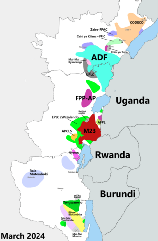
The Kivu conflict is an umbrella term for a series of protracted armed conflicts in the North Kivu and South Kivu provinces in the eastern Democratic Republic of the Congo which have occurred since the end of the Second Congo War. Including neighboring Ituri province, there are more than 120 different armed groups active in the eastern Democratic Republic of Congo. Currently, some of the most active rebel groups include the Allied Democratic Forces, the Cooperative for the Development of the Congo, the March 23 Movement, and many local Mai Mai militias. In addition to rebel groups and the governmental FARDC troops, a number of national and international organizations have intervened militarily in the conflict, including the United Nations force known as MONUSCO, and an East African Community regional force.
Bunagana is a small town in Rutshuru Territory, North Kivu Province, in eastern Democratic Republic of the Congo, at the border with Uganda. It served as the headquarters of the March 23 Movement (M23) rebel militia in 2013 and has been occupied by M23 since 13 June 2022.
The March 23 Movement, often abbreviated as M23 and also known as the Congolese Revolutionary Army, is a Congolese rebel military group. Based in eastern areas of the Democratic Republic of the Congo (DRC), it operates mainly in the province of North Kivu, which borders both Uganda and Rwanda. The M23 rebellion of 2012 to 2013 against the DRC government led to the displacement of large numbers of people. On 20 November 2012, M23 took control of Goma, a provincial capital with a population of a million people, but it was requested to evacuate it by the International Conference on the Great Lakes Region because the DRC government had finally agreed to negotiate. In late 2012, Congolese troops, along with UN troops, retook control of Goma, and M23 announced a ceasefire and said that it wanted to resume peace talks.
Bunyakiri is a town located in the high plateau of Kalehe Territory in the South Kivu Province in the eastern region of the Democratic Republic of the Congo (DRC). Bunyakiri is nearby the Bulehe and Mulamba villages. It is mainly inhabited by Tembo, Havu, Twa and Hunde ethnic groups.
Nyiragongo Territory is a territory in North Kivu, Democratic Republic of the Congo.
The Alliance of Patriots for a Free and Sovereign Congo is an armed militia group which operates in the north-east of the Democratic Republic of the Congo. APCLS is traditionally active in Masisi Territory, North Kivu and is considered one of the largest mai-mai groups operating in the province. Formed in 2006, the APCLS draws most of its support from the Hunde ethnic group. Its ideology is founded on opposition to the Tutsi ethnic groups who are believed to threaten the integrity of the Congolese state and to be supported, in particular, by Rwanda. The APCLS is a belligerent in the ongoing Kivu conflict and is led by Janvier Buingo Karairi, known as General Janvier.
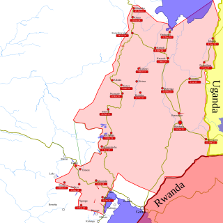
In late March 2022, the March 23 Movement (M23), supported by Rwanda, launched an offensive in North Kivu against the Armed Forces of the Democratic Republic of the Congo (FARDC) and MONUSCO. The fighting displaced hundreds of thousands of civilians and caused renewed tensions between the Democratic Republic of the Congo and Rwanda.
Constant Ndima Kongba is a Congolese military officer who served as the military governor of North Kivu from May 2021 to September 2023. Before this appointment, he had served in high-ranking positions in the Armed Forces of the Democratic Republic of the Congo (FARDC). In the Second Congo War (1998–2003), Ndima was a commander in the Movement for the Liberation of the Congo; in this role, he was involved in Operation Effacer le tableau, a campaign that resulted in genocidal massacres.
The Rubaya mines, also known as the Bibatama Mining Concession, is a series of coltan mining sites near the town of Rubaya in Masisi Territory, North Kivu, Democratic Republic of the Congo. Officially, the mining license is held by Société Minière de Bisunzu Sarl (SMB), associated with Congolese senator Édouard Mwangachuchu. Specific sites include Bibatama D2, Luwowo, Gakombe D4, Koyi, Mataba D2, Bundjali, and Bibatama D3.
Kinyandonyi is a village in the Rutshuru Territory of the North Kivu Province, Democratic Republic of the Congo. Kinyandonyi is situated 10 km east of the city of Kiwanja in Bukoma groupement, in the Bwisha Chiefdom and 85 km north of the capital of the province Goma. The region is inhabited by the Hunde people as well as some remaining autochthonous populations of African Pygmies, including the Twa people and the Mbuti people. In addition to the Hunde, Twa, and Mbuti, there are other ethnic groups, including the Nyanga, Lega, Kumu, Hutu and Tutsi.
Mount Hehu are large hills located in the Buhumba groupement (grouoing) within the Bukumu Chiefdom of the Nyiragongo Territory in the North Kivu Province, Democratic Republic of the Congo. Standing at an elevation of 2,430 meters, Mount Hehu is situated near Hibumba and Bungeshi Mukuru villages on the border of Rwanda and the Democratic Republic of the Congo.
Bibogobogo, alternatively referred to as Bibokoboko in Kibembe, is a village in the middle plateaus of the Mutambala Sector in the Fizi Territory in the South Kivu Province of the Democratic Republic of the Congo (DRC). It is situated in the forested mountains and middle plateaus, overlooking Baraka in the south-west, near Kisombe and Bibokoboko II villages. Geographically, Bibogobogo shares its boundaries with Uvira Territory to the north, Mwenga and Shabunda Territories to the west, Kalemie Territory to the south, and Lake Tanganyika to the east.
The Luindi Chiefdom, also known as the Lwindi Chiefdom, is a chiefdom located in the Mwenga Territory, within the South Kivu Province in the eastern region of the Democratic Republic of the Congo (DRC). It is situated in the mountainous area of the Itombwe Massif.
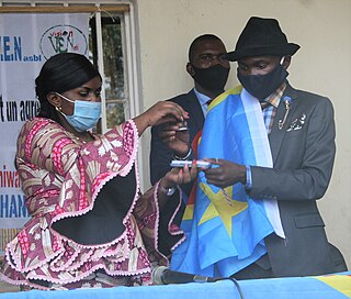
The Bwito Chiefdom is a chiefdom located in the Rutshuru Territory of North Kivu Province in the Democratic Republic of the Congo (DRC). It is bordered to the north by Batangi Chiefdom and Kanyabayonga commune in Lubero Territory, Bwisha Chiefdom in the east, and to the north-east by Lake Edward and the Republic of Uganda. To the west, it is bordered by Bashali Chiefdom in Masisi Territory, and to the northwest by Wanyanga Chiefdom in Walikale Territory. To the south, it is bordered by Nyiragongo Territory.
Between January 24 and 26, 2023, M23 rebels and Armed Forces of the Democratic Republic of the Congo (FARDC) soldiers fought over the city of Kitshanga. The battle was part of the renewed M23 offensive, and ended on January 26 with M23 forces capturing the city. Civilians accused both M23 and FARDC-aligned militias of war crimes during and after the battle.
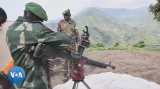
The Second battle of Kitshanga broke out between Rwandan-backed M23 fighters and self-defense groups known as Wazalendo allied with the Congolese government. In January 2023, M23 rebels captured Kitshanga from the Congolese Army and allied forces in their renewed offensive in North Kivu. Wazalendo forces captured Kitshanga in early October 2023 as part of a counteroffensive, with the city switching hands between Wazalendo and the M23 after October 16, and a second M23 offensive on October 21 capturing the town.
The Fally Ipupa Foundation is a non-profit organization established in 2013 by Congolese singer-songwriter Fally Ipupa. It aims to provide assistance to various marginalized groups in need in the Democratic Republic of the Congo (DRC), including victims of sexual violence, diseases, as well as orphans.
The Bashali Chiefdom is a chiefdom located in the Masisi Territory of North Kivu Province in the eastern region of the Democratic Republic of the Congo (DRC). Topographically, it is bounded to the east by the Virunga National Park, to the north by the Bwito Chiefdom of Rutshuru Territory, to the northwest by Walikale Territory, to the south by the Bahunde Chiefdom, and to the west by the Osso sector. Encompassing a total area of 1,582 square kilometers, the chiefdom is the administrative and sociopolitical structure for the Hunde ethnic group and is administratively subdivided into two groupements: Bashali-Mokoto and Bashali-Kaembe. Kitchanga, the urban center and administrative capital of the Bashali-Mokoto groupement, is the most densely populated locality within the chiefdom.
{{cite book}}
: CS1 maint: others (link)