Klickitat, Washington

Last updated

Klickitat, Washington
Klickitat sign.jpg
Sign at the entrance of town
Klickitat County Washington Incorporated and Unincorporated areas Klickitat Highlighted.svg
Location in Klickitat County, Washington
Coordinates: 45°49′05″N121°09′45″W / 45.81806°N 121.16250°W / 45.81806; -121.16250
Country United States
State Washington
County Klickitat
Area
  Total
0.94 sq mi (2.43 km2)
  Land0.94 sq mi (2.43 km2)
  Water0.0 sq mi (0.0 km2)
Elevation
[1]
689 ft (210 m)
Population
 (2020)
  Total
320
  Density340/sq mi (130/km2)
Time zone UTC-8 (Pacific (PST))
  Summer (DST) UTC-7 (PDT)
ZIP codes
98628, 98670
Area code 509
FIPS code 53-36115 [2]
GNIS feature ID2408494 [1]

Klickitat is an unincorporated community and census-designated place (CDP) in Klickitat County, Washington, United States. The population was 320 at the 2020 census. Once the site of a lumber mill, it is now primarily a bedroom community.

Contents

Geography

Klickitat is located along the Klickitat River. The closest major town is Goldendale, 21 miles (34 km) to the east. State Route 142 passes through Klickitat, leading southwest (downstream) 3 miles (5 km) to Pitt and east (upstream) the same distance to Wahkiacus. Lyle, along the Columbia River, is 13 miles (21 km) to the southwest via Route 142.

According to the United States Census Bureau, the Klickitat CDP has a total area of 0.93 square miles (2.4 km2), all of it land. [3]

Demographics

Historical population
CensusPop.Note
2000 417
2010 362−13.2%
2020 320−11.6%
US Decennial Census [4]
2020 Census [5]

As of the census [2] of 2000, there were 417 people, 147 households, and 110 families residing in the CDP. The population density was 161.9 people per square mile (62.4/km2). There were 173 housing units at an average density of 67.2/sq mi (25.9/km2). The racial makeup of the CDP was 92.33% White, 0.24% African American, 3.60% Native American, 0.96% Asian, and 2.88% from two or more races. Hispanic or Latino of any race were 2.64% of the population.

There were 147 households, out of which 43.5% had children under the age of 18 living with them, 58.5% were married couples living together, 10.2% had a female householder with no husband present, and 24.5% were non-families. 21.1% of all households were made up of individuals, and 5.4% had someone living alone who was 65 years of age or older. The average household size was 2.84 and the average family size was 3.28.

In the CDP, the population was spread out, with 35.5% under the age of 18, 7.7% from 18 to 24, 26.4% from 25 to 44, 20.6% from 45 to 64, and 9.8% who were 65 years of age or older. The median age was 30 years. For every 100 females, there were 84.5 males. For every 100 females age 18 and over, there were 94.9 males.

The median income for a household in the CDP was $28,750, and the median income for a family was $29,688. Males had a median income of $30,500 versus $16,250 for females. The per capita income for the CDP was $11,717. About 27.8% of families and 29.7% of the population were below the poverty line, including 32.5% of those under age 18 and 11.5% of those age 65 or over.

As of the census [2] of 2020, there were 320 people, 132 households, 160 housing units in the CDP. The racial makeup of the CDP was 275 Whites, 3 American Indians, 2 Asians, 9 Hispanic or Latino, 9 Some Other Race, and 32 of Two or More Races.

The median income for a household in the CDP was $60,893, and the median income for a family was $61,964. About 5.7% of the population were below the poverty line, including 6.3% of those under age 18 and 7.6% of those age 65 or over.

History

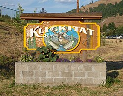
The site where the town is located was originally called "Wrights" after one of the original settlers. This was the name given to the rail stop there. The rail stop down the river at milepost 7.2 was named "Klickitat", after the Klickitat people and the railroad later switched the two signs when the carbonated beverage company Klickitat Pop (operating near the town) gained fame. On February 7, 1910, the name of the town post office was officially changed to "Klickitat". [6]

The first non-native settlers arrived in 1890 seeking land to homestead. The abundance of timber drew in other settlers during the early 1900s. Travel through the Klickitat canyon and up to the plateau was arduous until the completion of a rail line in 1903.[4, p. 47] The rail line eased travel and facilitated the transportation of people, crops, livestock and timber. The lumber mill was the primary employer in town, with the first major mill formed 1909, until 1994 when the mill was permanently closed. [7] The naturally carbonated Klickitat Mineral Springs just east of town gave rise to health spas, a carbonated beverage company, and a large dry ice plant which operated until 1957. [8]

Recreation

Klickitat Klickitat downtown.jpg
Klickitat

The area surrounding the town of Klickitat and the river which shares its name are renowned for their seasonal hunting and fishing. During summer, popular activities on the Klickitat River include recreational drift boating, kayaking, and rafting. Paths and trails provide opportunities for scenic hikes. The 31-mile-long (50 km) Klickitat Trail is on the route of the former railroad tracks, now a biking and hiking trail. The trail follows the Klickitat River north from the Columbia River past the town of Klickitat. [9] Washington State Route 142 provides a scenic drive through the canyon. Two miles east of town is the ruins of the dry ice plant with a single remaining building. The site is now a public campsite.

Related Research Articles

<span class="mw-page-title-main">Skamania County, Washington</span> County in Washington, United States

Skamania County is a county located in the U.S. state of Washington. As of the 2020 census, the population was 12,036. The county seat and largest incorporated city is Stevenson, although the Carson River Valley CDP is more populous. Skamania County is included in the Portland-Vancouver-Hillsboro, OR-WA Metropolitan Statistical Area.

<span class="mw-page-title-main">Klickitat County, Washington</span> County in Washington, United States

Klickitat County is a county located in the U.S. state of Washington. As of the 2020 census, the population was 22,735. The county seat and largest city is Goldendale. The county is named after the Klickitat tribe.

<span class="mw-page-title-main">Peridot, Arizona</span> CDP in Arizona, US

Peridot is an unincorporated community and census-designated place (CDP) in Gila and Graham counties in the U.S. state of Arizona. The population was 1,350 at the 2010 census.

<span class="mw-page-title-main">Schurz, Nevada</span> Census-designated place in Nevada, United States

Schurz is an unincorporated community and census-designated place (CDP) in Mineral County, Nevada, United States. The population was 656 at the 2020 census. It is located on the Walker River Indian Reservation and is the burial place of Wovoka, the Paiute messiah who originated the Ghost Dance movement.

<span class="mw-page-title-main">Rothsville, Pennsylvania</span> Census-designated place in Pennsylvania, United States

Rothsville is an unincorporated community and census-designated place (CDP) in Warwick Township, Lancaster County, Pennsylvania, United States. The population was 3,044 at the 2010 census. Lititz is the town for residents' mailing addresses.

<span class="mw-page-title-main">Warren, Vermont</span> Town in Vermont, United States

Warren is a town in Washington County, Vermont, United States. The population was 1,977 at the 2020 census. The center of population of Vermont is located in Warren. It is set between the two ranges of the Green Mountains, with approximately 25% of the township within the boundaries of the federal Green Mountain National Forest.

<span class="mw-page-title-main">Battle Ground, Washington</span> City in Washington, United States

Battle Ground is a city in Clark County, Washington, United States. The population was 20,743 at the 2020 census. As of 2023, its population is 22,285.

<span class="mw-page-title-main">Bickleton, Washington</span> Census-designated place in Washington, United States

Bickleton is an unincorporated community and census-designated place in Klickitat County, Washington, United States. Bickleton was first settled by Charles N. Bickle and established in 1879. The population was 92 at the 2020 census, up from 88 at the 2010 census.

<span class="mw-page-title-main">Centerville, Washington</span> Census-designated place in Washington, United States

Centerville is an unincorporated community and census-designated place (CDP) in Klickitat County, Washington, United States. Settled in 1877 by Albert J. Brown, the population was 94 at the 2020 census.

<span class="mw-page-title-main">Dallesport, Washington</span> Census-designated place in Washington, United States

Dallesport is an unincorporated community and census-designated place (CDP) in Klickitat County, Washington, United States. The population was 1,328 at the 2020 census.

<span class="mw-page-title-main">Lyle, Washington</span> Census-designated place in Washington, United States

Lyle is an unincorporated community and census-designated place (CDP) in Klickitat County, Washington, United States. The population was 518 at the 2020 census.

<span class="mw-page-title-main">Maryhill, Washington</span> Census-designated place in Washington, United States

Maryhill is an unincorporated community and census-designated place (CDP) in Klickitat County, Washington, United States. The population was 55 at the 2020 census.

<span class="mw-page-title-main">Roosevelt, Washington</span> Census-designated place in Washington, United States

Roosevelt is an unincorporated community and census-designated place (CDP) in Klickitat County, Washington, United States. The population was 152 at the 2020 census. The Roosevelt Regional Landfill, one of the largest landfills in the United States, is located at Roosevelt.

<span class="mw-page-title-main">Trout Lake, Washington</span> Census-designated place in Washington, United States

Trout Lake is an unincorporated community and census-designated place (CDP) in Klickitat County, Washington, United States. The population was 672 at the 2020 census. The town is notable for its organic dairy and herb farms, and as an access point to Mount Adams and the Gifford Pinchot National Forest.

Whitefield is a census-designated place (CDP) and the main village in the town of Whitefield in Coos County, New Hampshire, United States. The population of the CDP was 1,460 at the 2020 census, out of 2,490 people in the entire town of Whitefield.

Enfield is a census-designated place (CDP) and the main village in the town of Enfield in Grafton County, New Hampshire, United States. The population of the CDP was 1,571 at the 2020 census, out of 4,465 in the entire town.

<span class="mw-page-title-main">Middlebury (CDP), Vermont</span> Census-designated place in Vermont, United States

Middlebury is the main settlement in the town of Middlebury in Addison County, Vermont, United States, and a census-designated place (CDP). The population was 7,304 at the 2020 census, out of a total population of 9,152 in the town of Middlebury. Most of the village is listed on the National Register of Historic Places as the Middlebury Village Historic District.

Woodland is a census-designated place (CDP) in the town of Baileyville, Washington County, Maine, United States. The population was 952 at the 2010 census.

<span class="mw-page-title-main">Hudson (CDP), Massachusetts</span> Census-designated place in Massachusetts, United States

Hudson is a census-designated place (CDP) comprising the densely developed central part of the town of Hudson in Middlesex County, Massachusetts, United States. The population of the CDP was 15,749 at the 2020 census, out of 20,092 in the entire town.

<span class="mw-page-title-main">East Hampton, Connecticut</span> Town in Connecticut, United States

East Hampton is a town in Middlesex County, Connecticut, United States. The town is part of the Lower Connecticut River Valley Planning Region. The population was 12,717 at the 2020 census. The town center village is listed as a census-designated place (CDP). East Hampton includes the communities of Cobalt, Middle Haddam, and Lake Pocotopaug.

References

  1. 1 2 U.S. Geological Survey Geographic Names Information System: Klickitat, Washington
  2. 1 2 3 "U.S. Census website". United States Census Bureau . Retrieved January 31, 2008.
  3. "Geographic Identifiers: 2010 Census Summary File 1 (G001), Klickitat CDP, Washington". American FactFinder. U.S. Census Bureau. Archived from the original on February 13, 2020. Retrieved July 10, 2019.
  4. "US Gazetteer files: 2010, 2000, and 1990". United States Census Bureau. February 12, 2011. Retrieved April 23, 2011.
  5. "Census Bureau profile: Klickitat, Washington". United States Census Bureau. May 2023. Retrieved May 13, 2024.
  6. Niels, Selma. So This Is Klickitat (1967) [p. 62]
  7. "Klickitat County -- Thumbnail History". www.historylink.org.
  8. "Klickitat Mineral Springs History". www.walkaboutmag.com. Archived from the original on March 5, 2012. Retrieved January 15, 2022.
  9. "KTC :: Dedicated to the preservation and promotion of the Klickitat Trail". www.klickitat-trail.org.

Further reading