
Moshoeshoe I International Airport is an airport serving Maseru, the capital city of Lesotho. The airport is named in honor of Moshoeshoe I, king of Lesotho from 1822 to 1870. It is in the town of Mazenod, 18 km (11 mi) southeast of downtown Maseru.
N'Dolo Airport, also known as Ndolo Airport, is a secondary airport in the city of Kinshasa, Democratic Republic of the Congo, located in the commune of Barumbu near the city center.

Matekane Air Strip is a high elevation airstrip serving Matekane, Lesotho, with a runway that extends to the edge of a 500 m (1,600 ft) cliff. The runway is often used by charity organizations and doctors to access remote villages in the area, and is known as one of the world's scariest runways.
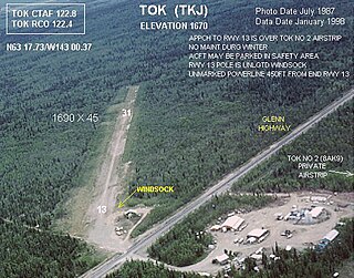
Tok Airport was a state-owned public-use airport located two nautical miles (4 km) south of the central business district of Tok, in the Southeast Fairbanks Census Area of the U.S. state of Alaska.

Mejametalana Airport is a military airport in Maseru, the capital city of Lesotho. It served as Maseru's main airport until the opening of Moshoeshoe I International Airport, located in the town of Mazenod, about 18 km (11 mi) southeast of downtown Maseru.
El Tuqui Airport, is an airport serving Ovalle, a city in the Coquimbo Region of Chile.
Lebakeng Airport is an airport serving the settlement of Lebakeng, Lesotho.
Leribe Airport is an airport serving Hlotse, the camptown (capital) of the Leribe District of Lesotho.
Lesobeng Airport is an airstrip serving the community of Lesobeng, in the Thaba-Tseka District of Lesotho.
Mafeteng Airport is an airport serving the city of Mafeteng, the capital of Mafeteng District, Lesotho.
Pelaneng Airport is an airport serving the settlement of Pelaneng, Lesotho.
Seshutes Airport or Seshote Airport is an airport serving the village of Seshote in Leribe District, Lesotho.
Mantšonyane Airport is an airport serving the town of Mantšonyane in Thaba-Tseka District, Lesotho.
Katse Airport is an airport serving the Katse Dam section of the Lesotho Highlands Water Project in north-central Lesotho.
Bobete Airport is an airport serving Bobete, a village in the Thaba-Tseka District of Lesotho.
Letseng Airport is an airstrip serving the Letseng diamond mine in Mokhotlong District, Lesotho. The runway is at very high elevation, 10,084.8 feet.
Malefiloane Airstrip is a high elevation airstrip serving the village of Malefiloane in Mokhotlong District, Lesotho. The runway is on a ridge above the Mokhotlong River valley.
Semenanyane Airport is a well-marked airstrip serving the mission village of Semenanyane in Mokhotlong District, Lesotho. The runway is near the border with Thaba-Tseka District.
Kuebunyane Airport is an airstrip serving the Basotho villages of Kuebunyane in Mohale's Hoek District, Lesotho.
