
Lesotho, formally the Kingdom of Lesotho, is a landlocked country in Southern Africa. As an enclave of South Africa, with which it shares a 1,106 km (687 mi) border, it is the largest sovereign enclave in the world, and the only one outside of the Italian Peninsula. It is situated in the Maloti Mountains and contains the highest peak in Southern Africa. It has an area of over 30,000 km2 (11,600 sq mi) and has a population of about two million. Its capital and largest city is Maseru. The country is also known by the nickname The Mountain Kingdom.

Lesotho is a mountainous, landlocked country located in Southern Africa. It is an enclave, surrounded by South Africa. The total length of the country's borders is 909 kilometres (565 mi). Lesotho covers an area of around 30,355 square kilometres (11,720 sq mi), of which a negligible percentage is covered with water.

Mokhotlong is a constituency, city and seat of Mokhotlong District in the mountainous northeastern part of Lesotho. It is the first major city with an airport along the road from South Africa across the Sani Pass, near the Maloti Mountains. The name of the city is a word in Sesotho, the language of the people of Lesotho, meaning "Place of the Bald Ibis." Thabana Ntlenyana, the highest point in southern Africa, is found in Mokhotlong.
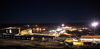
The Letšeng Diamond Mine, found in the landlocked Southern African kingdom of Lesotho, is owned by Gem Diamonds, Ltd. and the government of Lesotho, at an elevation of 3,100 m (10,200 ft) it is the world's highest diamond mine.

Gem Diamonds is a British-based global diamond mining business. It is headquartered in London and is listed on the London Stock Exchange. In 2017, the company generated a profit of $20.8 million.

Matekane Air Strip is a high elevation airstrip serving Matekane, Lesotho, with a runway that extends to the edge of a 500 m (1,600 ft) cliff. The runway is often used by charity organizations and doctors to access remote villages in the area, and is known as one of the world's scariest runways.
Mathula is a community council located in the Mafeteng District of Lesotho. Its population in 2006 was 17,867.
Mateanong is a community council located in the Mokhotlong District of Lesotho. Its population in 2006 was 7,387.
Pae-La-Itlhatsoa is a community council located in the Mokhotlong District of Lesotho. Its population in 2006 was 2,080.
Leribe Airport is an airport serving Hlotse, the camptown (capital) of the Leribe District of Lesotho.
Mafeteng Airport is an airport serving the city of Mafeteng, the capital of Mafeteng District, Lesotho.
Mokhotlong Airport is an airport serving Mokhotlong, the camptown of Mokhotlong District, Lesotho.
Quthing Airport is an airport serving the settlement of Quthing, Lesotho.
Sekake Airport is an airport serving the village of Sekake, Lesotho.
Seshutes Airport or Seshote Airport is an airport serving the village of Seshote in Leribe District, Lesotho.
The mining industry of Lesotho is mostly concentrated on diamond mining and as such the mining sector in the country has not played any significant role in furthering its economy. Apart from diamonds, the country's main mineral resources have been identified as base metals, clays, dimension stone, sand, gravel and uranium. The lack of initiative to extract other minerals commercially is mainly attributed to the inadequacy of infrastructure and finances. Between 2000 and 2011, the percentage of GDP contributed by diamond mining to Lesotho's economy rose from "virtually zero" to about 4%.
Kolberg Airport is an airstrip serving the village of Letlapeng in the Thaba-Tseka District of Lesotho.
Lake Letsie is a reservoir in the Drakensberg mountains in Quthing District, Lesotho. The reservoir was formed when a smaller, natural lake was enlarged by damming the source of the Mohlakeng River in 1968. The lake and the wetlands surrounding the shore have been designated as a national protected area since 2001 and a Ramsar site since 2004.
