The Free State, formerly known as the Orange Free State, is a province of South Africa. Its capital is Bloemfontein, which is also South Africa's judicial capital. Its historical origins lie in the Boer republic called the Orange Free State and later the Orange Free State Province.

Hlotse is an important market town in Lesotho. It is situated on the Hlotse River, near the South African border. The town was founded in 1876 by a British missionary, Reverend John Widdicombe. It was a colonial centre until Lesotho gained its independence. The population in 2016 was 38,558.

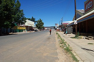
Ficksburg is a town situated at the foot of the 1,750 meter high Imperani Mountain in Free State province, South Africa. The town was founded by General Johan Fick in 1867 who won the territory in the Basotho Wars. He laid out many erven and plots that could be bought at a reasonable price. It is located on the north bank of the Mohokare River, which separates it from the town of Maputsoe in Lesotho. The town was later proclaimed a municipality in 1891. The last Governor-General of the Union of South Africa and the first State President of South Africa, Charles Robberts Swart was imprisoned here by the British in 1914 and released one day before his scheduled execution.

Maputsoe is a town and constituency located in the northern district of Leribe in Lesotho; it shares a border-post with Ficksburg in the Free State province of South Africa, with the Mohokare River forming the national boundary. It has a population of 55,541.

Setsoto FM Stereo is a South African community radio station based in the Free State. The station is directly responsible and accountable to Maluti Media Network as a community-based project; Setsoto FM is operated by volunteers from within the community of Greater Ficksburg and its surrounding areas.
Lebakeng Airport is an airport serving the settlement of Lebakeng, Lesotho.
Mafeteng Airport is an airport serving the city of Mafeteng, the capital of Mafeteng District, Lesotho.
Nkaus Airport is an airport serving the village of Nkaus, Lesotho.
Mokhotlong Airport is an airport serving Mokhotlong, the camptown of Mokhotlong District, Lesotho.
Quthing Airport is an airport serving the settlement of Quthing, Lesotho.
Qacha's Nek Airport is an airport serving Qacha's Nek, the camptown (capital) of Qacha's Nek District in Lesotho.
Tebellong Airport is an airport serving the village of Tebellong in Qacha's Nek District, Lesotho.
Seshutes Airport or Seshote Airport is an airport serving the village of Seshote in Leribe District, Lesotho.
Tlokoeng Airport is an airport serving the village of Tlokoeng in Mokhotlong District, Lesotho.
Mantšonyane Airport is an airport serving the town of Mantšonyane in Thaba-Tseka District, Lesotho.
Katse Airport is an airport serving the Katse Dam section of the Lesotho Highlands Water Project in north-central Lesotho.
Bobete Airport is an airport serving Bobete, a village in the Thaba-Tseka District of Lesotho.
Kolberg Airport is an airstrip serving the village of Letlapeng in the Thaba-Tseka District of Lesotho.
Letseng Airport is an airstrip serving the Letseng diamond mine in Mokhotlong District, Lesotho. The runway is at very high elevation, 10,084.8 feet.
Malefiloane Airstrip is a high elevation airstrip serving the village of Malefiloane in Mokhotlong District, Lesotho. The runway is on a ridge above the Mokhotlong River valley.


