In modern mapping, a topographic map or topographic sheet is a type of map characterized by large-scale detail and quantitative representation of relief features, usually using contour lines, but historically using a variety of methods. Traditional definitions require a topographic map to show both natural and artificial features. A topographic survey is typically based upon a systematic observation and published as a map series, made up of two or more map sheets that combine to form the whole map. A topographic map series uses a common specification that includes the range of cartographic symbols employed, as well as a standard geodetic framework that defines the map projection, coordinate system, ellipsoid and geodetic datum. Official topographic maps also adopt a national grid referencing system.

Topography is the study of the forms and features of land surfaces. The topography of an area may refer to the land forms and features themselves, or a description or depiction in maps.
Ghin-Doo-Ee is a national park in New South Wales, Australia, 200 km northeast of Sydney. Its name comes from the Gadjang word for the Australian brushturkey.

Nymboida is a national park in New South Wales, Australia, 485 km north of Sydney.
Single is a national park in New South Wales, Australia, 432 km north of Sydney. The park was established in 1999 and has an area of 25.63 km2. The average elevation of the terrain is 1033 meters.
Towarri is a national park located in New South Wales, Australia, 230 kilometres (140 mi) north of Sydney.
Warra is a national park in New South Wales, Australia, 438 km north of Sydney.
Yabbra is a national park in New South Wales, Australia, 598 km north of Sydney.
Ferntree Creek is a national park in Queensland, Australia, 97 km north of Brisbane.

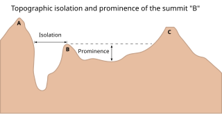
In topography, prominence measures the height of a mountain or hill's summit relative to the lowest contour line encircling it but containing no higher summit within it. It is a measure of the independence of a summit. The key col ("saddle") around the peak is a unique point on this contour line and the parent peak is some higher mountain, selected according to various criteria.

The National Map is a collaborative effort of the United States Geological Survey (USGS) and other federal, state, and local agencies to improve and deliver topographic information for the United States. The purpose of the effort is to provide "...a seamless, continuously maintained set of public domain geographic base information that will serve as a foundation for integrating, sharing, and using other data easily and consistently".

The elevation of a geographic location is its height above or below a fixed reference point, most commonly a reference geoid, a mathematical model of the Earth's sea level as an equipotential gravitational surface . The term elevation is mainly used when referring to points on the Earth's surface, while altitude or geopotential height is used for points above the surface, such as an aircraft in flight or a spacecraft in orbit, and depth is used for points below the surface.

Kunice is a municipality and village in Prague-East District in the Central Bohemian Region of the Czech Republic. It has about 1,800 inhabitants.
Kunice may refer to places:
Shorabak District is a remote district situated in the southeastern part of Kandahar Province, Afghanistan, 110 km south and east of Kandahar. It borders Reg District to the west, Spin Boldak District to the north and Pakistan to the east and south. The population is 13,020 as of 2020. The district center Shorabak is located at 985 m altitude in the Eastern part of the district.
Chinchali is a village in Raybag Taluk, Belagavi District, Karnataka, India. It is located near the state boundary with Maharashtra, approximately 84 kilometres north of the district seat Belgaum, and 10 kilometres northeast of the taluk seat Raibag. In the year 2011, the village has a population of 18,986.
Mohare is a village in Bailhongal Taluk, Belagavi District of Karnataka, India. It is located near the state border with Maharashtra, about 26 kilometres east of the district seat Belgaum, and 16 kilometres northwest of the taluk seat Bailhongal. As of 2011, it has a total population of 2,365.


