
The Shan people, also known as the Dai or Tai Yai, are a Tai ethnic group of Southeast Asia. The Shan are the biggest minority of Burma (Myanmar) and primarily live in the Shan State of this country, but also inhabit parts of Mandalay Region, Kachin State, and Kayin State, and in adjacent regions of China, Laos, Assam and Thailand. Though no reliable census has been taken in Burma since 1935, the Shan are estimated to number 4–6 million, with CIA Factbook giving an estimate of five million spread throughout Myanmar which is about 10% of the overall Burmese population.
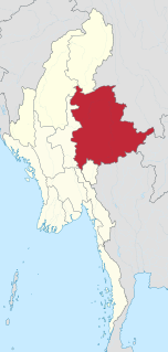
Shan State is a state of Myanmar. Shan State borders China (Yunnan) to the north, Laos to the east, and Thailand to the south, and five administrative divisions of Burma in the west. The largest of the 14 administrative divisions by land area, Shan State covers 155,800 km2, almost a quarter of the total area of Burma. The state gets its name from Burmese name for the Tai people: "Shan people". The Shan constitute the majority among several ethnic groups that inhabit the area. Shan is largely rural, with only three cities of significant size: Lashio, Kengtung, and the capital, Taunggyi. Taunggyi is 150.7 km northeast of the nation's capital Naypyitaw.

Myanmar is divided into twenty-one administrative subdivisions, which include states, regions, union territory, self-administered zones and self-administered division. Following is the table of government subdivisions and its organizational structure based on different states, regions, zones, division and the union territory:
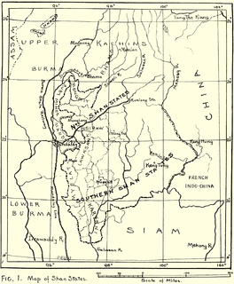
The Shan States (1885–1948) were a collection of minor Shan kingdoms called muang whose rulers bore the title saopha in British Burma. They were analogous to the princely states of British India.

Myelat is a historical region of the southwestern Shan State of Myanmar. Originally this region included some of the smaller states typically ruled by "Myosas" or "Ngwegunhmus", buffering the plains of Burma and the ethnic Shan states further east.

Mong Kung, Mongkung, Mongkaung or Möngkung is a town in Shan State some 100 kilometres east of Mandalay. It is the capital of Mong Kung Township, Myanmar.

Yawnghwe, known as Nyaungshwe in Burmese, was a Shan state in what is today Myanmar. It was one of the most important of the Southern Shan States. Yawnghwe state included the Inle Lake. The administrative capital was Taunggyi, located in the northern part of the state. The Agent of the British government, the Superintendent of the Southern Shan States, resided at Taunggyi and the king's palace was at Yawnghwe.
Kyawkku was a Shan state in the Myelat region of what is today Burma. Its capital was the village of Kyawkku (Myinkyado) which had 344 inhabitants in 1901.
Loi-ai was a Shan state in the Myelat region of what is today Burma. It was one of the westernmost Shan states, bordering with Yamethin district of Upper Burma. The capital was Lonpo (Aungpan) and the population was mostly Pa-O, but there were also Danu, Shan and Karen people in the area.
Sa-koi was a small Shan state in what is today Burma. It belonged to the Central Division of the Southern Shan States.
Hsatung was a Shan state in what is today Burma.
Kehsi Mansam was a Shan state in what is today Burma. It belonged to the Eastern Division of the Southern Shan States. Its capital was Kehsi town, located by the Nam Heng River. The state included 378 villages and the population was mostly Shan, but there were also some Palaung people (Yins) in the area
South Hsenwi was a Shan state in the Northern Shan States in what is today Burma. The capital was Mongyai town which had a population of about 2000 in the 19th century.
North Hsenwi was a Shan state in the Northern Shan States in what is today Burma. The capital was Lashio town which was also the headquarters of the superintendent of the Northern Shan State. North Hsenwi, with an area of 6330 m², had a population in 1901 of 118,325 persons and an estimated revenue of £6000.
Lawksawk, also known as Yatsawk was a Shan state in what is today Burma. It was located north of Myelat and belonged to the Central Division of the Southern Shan States. Its capital was Lawksawk town. The state included 397 villages and the population was mostly Shan, but there were also Danu, Pa-O and Palaung people in the area.

Mongpai, also known as Mobye, was a Shan state in what is today Burma. It belonged to the Central Division of the Southern Shan States.
Wanyin was a Shan state in what is today Burma. It belonged to the Central Division of the Southern Shan States.
Namtok was a Shan state in what is today Burma. It belonged to the Myelat Division of the Southern Shan States.
Yengan was a Shan state in what is today Burma. It belonged to the Myelat Division of the Southern Shan States.

The Shan Nationalities Democratic Party, also known as the White Tiger Party or Kya Phyu Party is a political party in Myanmar (Burma).


