Figueres is the capital city of Alt Empordà county, in the Girona region, Catalonia, Spain.
La Jonquera is a municipality in the comarca of l'Alt Empordà, in Catalonia, Spain. It is situated next to the border with Northern Catalonia, nowadays France, opposite the municipality of Le Perthus.
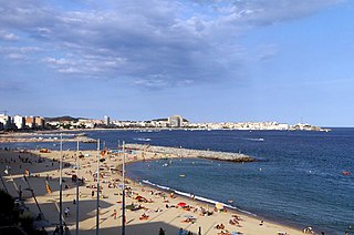
Palamós is a town and municipality in the Mediterranean Costa Brava, located in the comarca of Baix Empordà, in the province of Girona, Catalonia, Spain. Palamós is located at the northern end of a large bay. The town is by-passed by the C31 which connects the coastal towns of the central Costa Brava with Girona. Palafrugell lies 8.5 kilometres (5.3 mi) to the north and Castell-Platja d'Aro 7 kilometres (4.3 mi) to the south.

Portbou is a town in the Alt Empordà county, in the Province of Girona, Catalonia, Spain. It has a population of 1077 people (2018).

Cantallops is a municipality in the comarca of the Alt Empordà in Girona, Catalonia, Spain. It is situated below the Albera Range, and is linked to La Jonquera by the GI-601 road.

Cassà de la Selva is a municipality in the comarca of the Gironès in Catalonia, It is linked to Girona and to the Baix Empordà by the C-65 road. During the 20th century it was known for the production of cork and derived articles. With an increasing population of 9,200 citizens, this municipality is located 12 km south of Girona and 20 km west of the Mediterranean Sea.

Vilobí d'Onyar is a municipality in the comarca of the Selva in Catalonia, Spain. It is situated in the valley of the Onyar river, on the GE-533 road between Santa Coloma de Farners and Riudellots de la Selva. A substantial part of the northern portion of the municipality is taken up by Girona-Costa Brava Airport.

Calonge is a municipality in the comarca of the Baix Empordà in Catalonia, Spain, on the coastline of the Costa Brava.
La Coma i la Pedra is a municipality in the comarca of the Solsonès in Catalonia, Spain. It is situated in the Lord valley in the north of the comarca. The Cardener river has its source in the territory of the municipality. The local economy is traditionally based on livestock raising, although there is also a ski resort in the pyrenean massif of Port del Comte and a power station at Gafa. Local roads link the municipality with Sant Llorenç de Morunys and Josa i Tuixén.

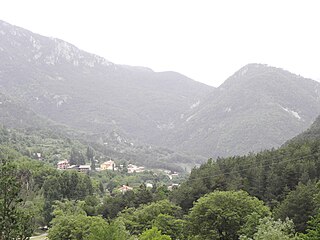
Sant Llorenç de Morunys is a municipality in the comarca of the Solsonès in Catalonia, Spain. It is situated in the Lord valley in the north of the comarca below the pyrenean massif of Port del Comte. The shrine of Lord is located in an exclave of the municipality between Guixers and Navès. The town is served by the L-401 road between Coll de Nargó and Berga.

Boadella i les Escaules is a municipality in the comarca of the Alt Empordà in Girona, Catalonia, Spain. The former name, Boadella d'Empordà, was changed in 2004 when the town of Les Escaules joined Boadella d'Empordà. It is situated in the valley of the Muga river, which is dammed to form the reservoir of Pantà de Boadella, a tourist attraction, and to generate hydroelectric power. Local roads link the village with Biure and Terrades.
L'Ampolla is a municipality in the comarca of the Baix Ebre in Catalonia, Spain. It was created in 1990 by the division of the municipality of el Perelló. It is situated on the coast south of l'Ametlla de Mar, and is an important tourist centre and minor fishing port. The town is served by the A-7 autopista, the N-340 coast road and by a station on the RENFE railway line between Tarragona and Valencia.

Sant Feliu de Guíxols is a municipality in the comarca of the Baix Empordà in Catalonia, Spain. It is situated on the Costa Brava and is an important port and tourist centre. The district abuts to the north, the upmarket s'Agaró resort built round the Sant Pol Beach. In addition to tourism and the port the cork industry is a traditionally local industry. The town contains a large monastery which now houses the town museum and is a protected historico-artistic monument.

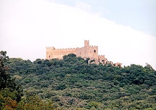
El Port de la Selva is a municipality in the comarca of the Alt Empordà in Catalonia, Spain, on the Costa Brava. It is situated on the northern coast of the Cap de Creus and is an important fishing port and tourist centre. The romanesque abbey of Sant Pere de Rodes is particularly notable.

Llançà is a municipality in the comarca of the Alt Empordà in Catalonia, Spain. It is situated on the coastline of the Costa Brava, between the Cap de Creus and the French frontier and is an important fishing port and tourist centre. The N-260 connects the town with Figueres and continues on to the border at Portbou.
Torroella de Montgrí is a coastal municipality on the Costa Brava, and small town in Catalonia, Spain. The town lies on the north bank of the Ter river, a few kilometres before it flows into the Mediterranean. The beach resort of L'Estartit also is part of the municipality, as are the Medes Islands and a large part of the Montgrí Massif.

Terrades is a municipality in the comarca of the Alt Empordà in Catalonia, Spain. It is situated to the west of Figueres, above the valley of the Muga river, and is linked to the rest of the comarca by the GE-510 road.

Biure is a municipality in the comarca of the Alt Empordà in Girona, Catalonia, Spain. It is situated to the north-west of Figueres, to which it is linked by the GE-504 road.

Folgueroles is a municipality in the comarca of Osona in Catalonia, Spain. It was the birthplace in 1845 of the famous Catalan poet Fr. Jacint Verdaguer.

Llagostera is a municipality in the comarca of the Gironès in Catalonia, Spain. During the 20th century, it was known for the production of cork and derived articles. It is located 20 km south of Girona and 15 km west from the Mediterranean Sea.