La Libertad, California

Last updated
La Libertad
Locale
USA California location map.svg
Red pog.svg
La Libertad
Location in California
Coordinates: 36°28′50.38″N119°52′44.54″W / 36.4806611°N 119.8790389°W / 36.4806611; -119.8790389
Country United States
State California
County Fresno County
Elevation [1] 216 ft (66 m)

La Libertad, California is a former settlement in Fresno County, California that was 1/2 mile south and 5 miles east of Burrel, California. It was an early Mexican settlement in San Joaquin Valley, on the eastern route of El Camino Viejo that existed there at least until 1870. [2]

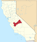
Fresno County, California County in California

Fresno County, officially the County of Fresno, is a county located in the central portion of the U.S. state of California. As of January 1, 2018, the population was 1,007,229. The county seat is Fresno, the fifth-largest city in California.

Burrel, California Unincorporated community in California, United States

Burrel is an unincorporated community in Fresno County, California. It is located 30 miles (48 km) southwest of Fresno, at an elevation of 203 feet.

San Joaquin Valley Valley in California

The San Joaquin Valley is the area of the Central Valley of the U.S. state of California that lies south of the Sacramento–San Joaquin River Delta and is drained by the San Joaquin River. It comprises seven counties of Northern and one of Southern California, including, in the north, all of San Joaquin and Kings counties, most of Stanislaus, Merced, and Fresno counties, and parts of Madera and Tulare counties, along with a majority of Kern County, in Southern California. Although a majority of the valley is rural, it does contain cities such as Fresno, Bakersfield, Stockton, Modesto, Turlock, Tulare, Porterville, Visalia, Merced, and Hanford.

Related Research Articles

Rancho Laguna Seca was a 2,179-acre (8.82 km2) Mexican land grant in present-day Monterey County, California given in 1834 by Governor José Figueroa to Catalina M. Munras. "Laguna Seca" means "Dry Lake" in Spanish, referring to the seasonal lake, Laguna Seca. The grant was east of present-day Monterey.

Los Gatos Creek formerly known as Arroyo Pasajero or Arroyo Poso de Chane, is a creek in Fresno County, California. Its source is in the north end of Garcia Canyon in the Diablo Range near Benito Pass. From there it runs through Los Gatos Canyon, in the eastern foothills of the Diablo Range, then passes across Pleasant Valley, north of Coalinga, where Warthan Creek joins it east of the town. Then it flows eastward to its confluence with Jacalitos Creek, before it passes to the north of the Guijarral Hills, into the San Joaquin Valley, where it is joined by Zapato Chino Creek.

Rancho de los Californios, California Locale in California, United States

Rancho de los Californios is a former settlement in Fresno County, California. It was located east of Pueblo de las Juntas on high ground near the south bank of the San Joaquin River. Its site is near the corner of Ashlan and North Lake Avenues, 4miles north of the Whitesbridge Road and 6 miles west of Biola, California.

Asphalto, California Former settlement in California, United States

Asphalto is a former settlement in Kern County, California. It was located on the railroad 3 miles (4.8 km) northeast of McKittrick, at an elevation of 932 feet. Asphalto still appeared on maps as of 1932.

Quartzburg is a former settlement in Mariposa County, California. It was located on Burns Creek 2 miles (3.2 km) upstream from Hornitos.

Rancho Saucos was a 22,212-acre (89.89 km2) Mexican land grant in present-day Tehama County, California given in 1844 by Governor Manuel Micheltorena to Robert H. Thomes. The name means "Ranch of the Elder trees". The grant extended along the west side of the Sacramento River from Elder Creek and Rancho Las Flores on the north to Thomes Creek on the south, and encompassed present-day Tehama.

Rancho Calleguas was a 9,998-acre (40.46 km2) Mexican land grant in present-day Ventura County, California given in 1837 by Governor Juan Alvarado to José Pedro Ruiz.

Rancho La Goleta was a 4,426-acre (17.91 km2) Mexican land grant in present-day Santa Barbara County, California given in 1846 by Governor Pío Pico to Daniel A. Hill. The grant extended along the Pacific coast from today’s Fairview Avenue in present-day Goleta, east to Hope Ranch. The grant was adjacent to Rancho Dos Pueblos granted to his son-in-law Nicolas A. Den in 1842.

Rancho Saucito was a 2,212-acre (8.95 km2) Mexican land grant in present day Monterey County, California given in 1833 by Governor José Figueroa to Graciano Manjares. The grant was located east of Monterey and the present day Monterey Regional Airport, and is bordered on the east by Rancho Laguna Seca.

Rancho Cañada de la Carpenteria was a 2,236-acre (9.05 km2) Mexican land grant in present day Monterey County, California given in 1835 by Governor José Castro to Joaquín Soto. The name means valley of the carpenter's shop. The grant was near the San Benito County, California line, in hilly terrain north of Rancho Los Carneros and encompassed the former settlement of Dunbarton.

Rancho Panoche de San Juan y Los Carrisalitos was a 22,175-acre (89.74 km2) Mexican land grant in present-day Merced County, California given in 1844 by Governor Manuel Micheltorena to Julian Ursua and Pedro Romo. The name means "raw sugar of San Juan and the little patches of reeds" in Spanish.

Poso de Chane or Poso Chane is a former settlement in Fresno County, California situated around the waterhole of that name, northwest just below the confluence of the Jacalitos Creek with Los Gatos Creek, 6 miles (9.7 km) east of Coalinga and northwest of the Guijarral Hills.

Vaca Adobe or Vaca Dugout is a former settlement in what was then Tulare County, now Kings County, California. It was located at a stopping place on the eastern route of the El Camino Viejo about 3 miles north of the site of what is now Kettleman City close to the shore of Tulare Lake. The adobe at the site was known as the Vaca Dugout, and was built in 1863 by vaqueros Juan Perria and Pablo Vaca. In 1863, California was in the midst of the severe 1863-64 drought that would kill most of the cattle in the southern part of the state. Tulare Lake and the tules marshes around it were one of the few places cattle could get feed and water. The adobe was the headquarters for the vaqueros who were tending the herds in the vicinity.

San Francisquito Pass

San Francisquito Pass is a mountain pass in the Sierra Pelona Mountains, located northeast of Green Valley and Santa Clarita, in northern Los Angeles County, California.

Jacalitos Creek stream in Fresno County, United States of America

Jacalitos Creek formerly known as Arroyo de Jacelitos, is a creek in Fresno County, California.

Canoas Creek (Fresno County, California) river in the United States of America

Canoas Creek formerly known as Arroyo de Las Canoas is a creek in Fresno County, California. Its source is on the north slope of Black Mountain, 1.25 miles west of Zwang Peak in the Diablo Range. Its course in its canyon, runs almost directly northeast through Reef Ridge and the Kreyenhagen Hills, from which it flows north northeast into the Kettleman Plain where it turns north northwest 4.6 miles northwest of Avenal near the Kettleman Hills to terminate in the Kettleman Plain, 7.1 miles northwest of Avenal and 3000 feet east of Zapato Chino Creek.

Cox & Clark Trading Post was an adobe building on the west shore of Tulare Lake. It was at that time the only building on that side of the lake and was located on the lakeshore 3 miles (4.8 km) southwest of the modern Kettleman City.

Mission Pass (Alameda County)

Mission Pass, also known as the Sunol Grade and formerly as Stockton Pass, is a gap in the hills of the Mount Hamilton Range in Alameda County, California. It lies to the northeast of Mission San José, in Fremont, and leads from there into the Sunol Valley. Its elevation is 659 feet (201 m) above sea level. Today, Interstate 680 traverses this pass.

Widow Smith's Station, also known as Major Gordon's Station and Clayton's Station, was a stagecoach station of the Butterfield Overland Mail 1st Division from 1858 to 1861 in southern California.

Lone Willow Station, was a former settlement in Merced County, California, located near present-day Los Banos. Lone Willow Station was a changing or swing station along the First Division route of the Butterfield Overland Mail, from 1858 to 1861. Lone Willow Station was located on the west bank of Mud Slough, 18 miles east of the St. Louis Ranch Station and 13 miles northwest of Temple's Ranch Station. This station consisted of a house for the hostler and a large barn for the relay horses and storage of their barley and hay.

References

Coordinates: 36°28′50″N119°52′45″W / 36.48066°N 119.87904°W / 36.48066; -119.87904

Geographic coordinate system Coordinate system

A geographic coordinate system is a coordinate system that enables every location on Earth to be specified by a set of numbers, letters or symbols. The coordinates are often chosen such that one of the numbers represents a vertical position and two or three of the numbers represent a horizontal position; alternatively, a geographic position may be expressed in a combined three-dimensional Cartesian vector. A common choice of coordinates is latitude, longitude and elevation. To specify a location on a plane requires a map projection.