Lone Star, Lone Starr, Lone Stars or Lonestar may also refer to:
Dunlap is an unincorporated community in Fresno County, California. It lies at an elevation of 1,919 ft (585 m). It has a population of 131. It is located approximately 38 miles (61 km) east of Fresno. In the 1800s Dunlap was a rest stop for passengers of the stage coach and a location for a change of horses.
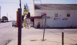
Rolinda is a small unincorporated agricultural community in Fresno County, California, United States. It is located on the Southern Pacific Railroad 10 miles (16 km) west of downtown Fresno, at an elevation of 253 feet. It is located along State Route 180. Official U.S. Geological Survey coordinates for the community are 36°44′07″N119°57′43″W. The community is in area code 559. It does not have its own ZIP code and mail uses the Fresno ZIP code of 93706.

Pinedale is a previously unincorporated community in Fresno County, California. It lies at an elevation of 348 feet. It was once a rural community located on the Southern Pacific Railroad 3.5 miles (5.6 km) north-northwest of Clovis but has since become surrounded and annexed by the city of Fresno. Millerton Lake State Recreational Area is to its NE. The ZIP Code is 93650, and the community is inside area code 559.
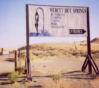
Mercey Hot Springs is an unincorporated community and historical hot springs resort in the Little Panoche Valley of Fresno County, central California, about 60 miles (97 km) west-southwest of Fresno.
Balch Camp is an unincorporated community in Fresno County, California. It is located near the confluence of the North Fork of the Kings River and Dinkey Creek 38 miles (61 km) east-northeast of Fresno, at an elevation of 1273 feet.
Burrel is an unincorporated community in Fresno County, California. It is located 30 miles (48 km) southwest of Fresno, at an elevation of 203 feet.
Calflax is an unincorporated community in Fresno County, California. It is located 20 miles (32 km) northeast of Coalinga, at an elevation of 276 feet.
Camden is an unincorporated community in Fresno County, California. It is located 3.5 miles (5.6 km) east of Riverdale, at an elevation of 236 feet.
Figarden was an unincorporated community in Fresno County, California. It is located 6 miles (9.7 km) northwest of downtown Fresno, at an elevation of 315 feet.
Herndon is an unincorporated community in Fresno County, California. It is located 9 miles (14 km) northwest of downtown Fresno, at an elevation of 299 feet.
Highway City is an unincorporated community in Fresno County, California. It is located 2.5 miles (4 km) southeast of Herndon, at an elevation of 299 feet.
Las Palmas is a former unincorporated community in Fresno County, California, now incorporated in Fresno. It lies at an elevation of 331 feet.
Miramonte is an unincorporated community in Fresno County, California. It is located on Mill Creek 5 miles (8 km) southeast of Dunlap, at an elevation of 3094 feet.
Oleander is an unincorporated community in Fresno County, California. It is located 9 miles (14 km) south-southeast of downtown Fresno, at an elevation of 285 feet.
Piedra is an unincorporated community in Fresno County, California. It is located on the south bank of the Kings River 23 miles (37 km) east of Fresno, at an elevation of 538 feet.
Pinehurst is an unincorporated community in Fresno County, California. It is located 6.5 miles (10 km) east-southeast of Dunlap, at an elevation of 4003 feet.
Sierra Sky Park is a fly-in unincorporated community in Fresno County, California. It is located 7 miles (11 km) northwest of downtown Fresno, at an elevation of 328 feet.
Westhaven is an unincorporated community in Fresno County, California. It is located 16 miles (26 km) south-southwest of Riverdale, at an elevation of 279 feet.
Humphreys Station is an unincorporated community in Fresno County, California. It is located 23 miles (37 km) northeast of Fresno.


