Tisechu, California

Last updated

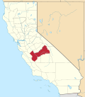
Tisechu (also, Tis-e-chu and Tishech) is a former Choinimni settlement in Fresno County, California. [1]

It was located at the confluence of Kings River and Mill Creek. [2]

The Choinimni were a branch of the Yokuts people.[ citation needed ]
Related Research Articles

California's 21st congressional district is a congressional district in the U.S. state of California. It is located in the San Joaquin Valley and includes parts of Fresno County and Tulare County. Cities in the district include the majority of Fresno, the north side of Visalia, and all of Sanger, Selma, Kingsburg, Parlier, Reedley, Orange Cove, Dinuba, Orosi, Cutler, Farmersville, Woodlake and Exeter. The district is currently represented by Democrat Jim Costa.

<span class="mw-page-title-main">Rolinda, California</span> Unincorporated community in California, United States

Rolinda is a small unincorporated agricultural community in Fresno County, California, United States. It is located on the Southern Pacific Railroad 10 miles (16 km) west of downtown Fresno, at an elevation of 253 feet. It is located along State Route 180. Official U.S. Geological Survey coordinates for the community are 36°44′07″N119°57′43″W. The community is in area code 559. It does not have its own ZIP code and mail uses the Fresno ZIP code of 93706.

<span class="mw-page-title-main">Shafter Airport</span> Airport in Kern County, California

Shafter Airport, also known as Minter Field and formerly known as Air Corps Basic Flying School, is a public use airport located four nautical miles east of the central business district of Shafter and 14 miles northwest of Bakersfield, a city in Kern County, California, United States. Originally a World War II primary training facility for pilots, it is currently a public airport owned by the Minter Field Airport District. This airport is included in the National Plan of Integrated Airport Systems for 2011–2015, which categorized it as a general aviation facility.

State Center Community College District (SCCCD) is a California Community Colleges System district in Central California, including Fresno City College in Fresno, Reedley College in Reedley, and Clovis Community College in north Fresno, and Madera Community College in Madera. Madera College also maintains a satellite campus, the Oakhurst Community College Center in Oakhurst.

<span class="mw-page-title-main">Salinian Block</span> Terrane west of the main trace of the San Andreas Fault system in California

The Salinian Block or Salinian terrane is a geologic terrane which lies west of the main trace of the San Andreas Fault system in California. It is bounded on the south by the Big Pine Fault in Ventura County and on the west by the Nacimiento Fault. It was named for the Salinas Valley in Monterey County, California.

Camden is an unincorporated community in Fresno County, California. It is located 3.5 miles (5.6 km) east of Riverdale, at an elevation of 236 feet.

Conejo is an unincorporated community in Fresno County, California. It is located 7.25 miles (11.7 km) west-southwest of Selma, at an elevation of 262 feet.

Herndon is an unincorporated community in Fresno County, California. It is located 9 miles (14 km) northwest of downtown Fresno, at an elevation of 299 feet.

Miramonte is an unincorporated community in Fresno County, California. It is located on Mill Creek 5 miles (8 km) southeast of Dunlap, at an elevation of 3094 feet.

Navelencia is an unincorporated community in Fresno County, California, United States. It is located 7 miles (11 km) east-southeast of Centerville, at an elevation of 420 feet. The farmland surrounding Navelencia supports orchards of oranges and other citrus trees. The township's name is a portmanteau of two varieties of oranges: navel and valencia. This orange-themed naming is shared with the neighboring city, Orange Cove.

Oleander is an unincorporated community in Fresno County, California. It is located 9 miles (14 km) south-southeast of downtown Fresno, at an elevation of 285 feet.

Sentinel is a former settlement in Fresno County, California. It was located 2.5 miles (4 km) west of Humphreys Station, at an elevation of 843 feet. It still appeared on maps as of 1924.

Sierra Sky Park is a fly-in unincorporated community in Fresno County, California. It is located 7 miles (11 km) northwest of downtown Fresno, at an elevation of 328 feet.

Trimmer is an unincorporated community in Fresno County, California. It is located 8 miles (13 km) north-northeast of Piedra, at an elevation of 1030 feet.

Westhaven is an unincorporated community in Fresno County, California. It is located 16 miles (26 km) south-southwest of Riverdale, at an elevation of 279 feet.

Wildflower is an unincorporated community in Fresno County, California. It is located 6 miles (9.7 km) southwest of Selma, at an elevation of 269 feet.

Lime Kiln Creek is a stream within Tulare County in central California. An alternative name for this creek is Dry Creek.

Rocky Hill is an unincorporated community in Tulare County, California. It lies at an elevation of 1549 feet.

La Libertad, California is a former settlement in Fresno County, California that was 1/2 mile south and 5 miles east of Burrel, California. It was an early Mexican settlement in San Joaquin Valley, on the eastern route of El Camino Viejo that existed there at least until 1870.

<span class="mw-page-title-main">Helm Field</span> US Army training airfield in Fresno County, California

Helm Field also called Lemoore Auxiliary Army Airfield A-7 is a former US Army Airfield use for training during World War II. Helm Field was location in the town of Coalinga, California, 70 miles south of Fresno. Helm Field had two 3,000 foot runways, one oriented east/west and one oriented northwest/southeast. The Airfield was on a 773 acres site of form farm land. The US Army purchased the land on January 11, 1943 for training pilots. The Airfield was used by the Lemoore Basic Flying School, based at the Lemoore Army Air Field. Helm Field was 15 miles northwest of Lemoore Army Air Field. The Army built at Helm Field to support training stage house, control tower, motor pool building, crash truck shelter and latrines. Helm Field was used by Air Corps Basic Flying School, the AAF Basic Flying School, the AAF Pilot School, the 88th Air Base Squadron, the 3023rd Army Air Force Pilot School and the 461st Army Air Force Base Unit. The army closed Helm Field on October 15, 1844 and the Airfield was sold by the War Assets Administration. Helm Field was used as a farm labor camp in the 1950s. The east/west runway was returned to farmland. The northwest/southeast runway was still intact and was used as a civilian airfield till 1971.

References

  1. U.S. Geological Survey Geographic Names Information System: Tisechu, California
  2. Kroeber, A. L. (February 1907). "Shoshonean Dialects of California" (PDF). University of California Publications in American Archaeology and Ethnology. 4 (3). At page 120 of journal, or page 60 of PDF file. via The Internet Archive.

36°49′25″N119°20′50″W / 36.8237°N 119.3473°W / 36.8237; -119.3473