Sierra Sky Park, California

Last updated

Coordinates: 36°50′32″N119°51′57″W / 36.84222°N 119.86583°W / 36.84222; -119.86583

Geographic coordinate system Coordinate system

A geographic coordinate system is a coordinate system that enables every location on Earth to be specified by a set of numbers, letters or symbols. The coordinates are often chosen such that one of the numbers represents a vertical position and two or three of the numbers represent a horizontal position; alternatively, a geographic position may be expressed in a combined three-dimensional Cartesian vector. A common choice of coordinates is latitude, longitude and elevation. To specify a location on a plane requires a map projection.

Sierra Sky Park
Unincorporated community
California Locator Map with US.PNG
Red pog.svg
Sierra Sky Park
Location in California
Usa edcp location map.svg
Red pog.svg
Sierra Sky Park
Sierra Sky Park (the US)
Coordinates: 36°50′32″N119°51′57″W / 36.84222°N 119.86583°W / 36.84222; -119.86583
Country United States
State California
County Fresno County
Elevation [1] 328 ft (100 m)

Sierra Sky Park is a fly-in unincorporated community in Fresno County, California. [1] It is located 7 miles (11 km) northwest of downtown Fresno, [2] at an elevation of 328 feet (100 m). [1]

Fly-in gathering of aviators

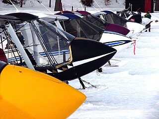
A fly-in is a pre-arranged gathering of aircraft, pilots and passengers for recreational and social purposes.

Unincorporated area Region of land not governed by own local government

In law, an unincorporated area is a region of land that is not governed by a local municipal corporation; similarly an unincorporated community is a settlement that is not governed by its own local municipal corporation, but rather is administered as part of larger administrative divisions, such as a township, parish, borough, county, city, canton, state, province or country. Occasionally, municipalities dissolve or disincorporate, which may happen if they become fiscally insolvent, and services become the responsibility of a higher administration. Widespread unincorporated communities and areas are a distinguishing feature of the United States and Canada. In most other countries of the world, there are either no unincorporated areas at all, or these are very rare; typically remote, outlying, sparsely populated or uninhabited areas.

Fresno County, California County in California

Fresno County, officially the County of Fresno, is a county located in the central portion of the U.S. state of California. As of January 1, 2018, the population was 1,007,229. The county seat is Fresno, the fifth-largest city in California.

Related Research Articles

Dunlap, California Unincorporated community in California, United States

Dunlap is an unincorporated community in Fresno County, California. It lies at an elevation of 1,919 ft (585 m). It has a population of 131. It is located approximately 38 miles (61 km) east of Fresno. In the 1800s Dunlap was a rest stop for passengers of the stage coach and a location for a change of horses.

Fresno California Temple

The Fresno California Temple is the 78th operating temple of The Church of Jesus Christ of Latter-day Saints.

Sierra Sky Park Airport is a privately owned, public-use airport located seven miles (11 km) northwest of the central business district of Fresno, a city in Fresno County, California, United States.

Balch Camp, California Unincorporated community in California, United States

Balch Camp is an unincorporated community in Fresno County, California. It is located near the confluence of the North Fork of the Kings River and Dinkey Creek 38 miles (61 km) east-northeast of Fresno, at an elevation of 1273 feet.

Biola Junction, California Unincorporated community in California, United States

Biola Junction is an unincorporated community in Fresno County, California. It is located on the Southern Pacific Railroad 5.5 miles (9 km) west-northwest of Fresno, at an elevation of 299 feet.

Bronge, California Former settlement in California, United States

Bronge is a former settlement in Fresno County, California. It was located on the Fresno Interurban Railroad 4.25 miles (6.8 km) south-southeast of Clovis, at an elevation of 338 feet. Bronge still appeared on maps as of 1923.

Camden, Fresno County, California Unincorporated community in California, United States

Camden is an unincorporated community in Fresno County, California. It is located 3.5 miles (5.6 km) east of Riverdale, at an elevation of 236 feet.

Camp Sierra, California Unincorporated community in California, United States

Camp Sierra is an unincorporated community in Fresno County, California. It is located 7 miles (11 km) north-northeast of Shaver Lake Heights, at an elevation of 4534 feet.

Elk, Fresno County, California Unincorporated community in California, United States

Elk is an unincorporated community in Fresno County, California. It is located on the Atchison, Topeka and Santa Fe Railroad 7.25 miles (12 km) southwest of Piedra, at an elevation of 413 feet.

Elm View, California Unincorporated community in California, United States

Elm View is an unincorporated community in Fresno County, California. It is located 15 miles (24 km) south of downtown Fresno, at an elevation of 256 feet.

Floyd, Fresno County, California Unincorporated community in California, United States

Floyd is an unincorporated community in Fresno County, California. It is located on the Southern Pacific Railroad 11 miles (18 km) west of downtown Fresno, at an elevation of 246 feet.

Fresno Beach, California Former settlement in California, United States

Fresno Beach is a former settlement in Fresno County, California. It was located at the terminus of a Fresno Traction Company branch line in the Scout Island area 7.5 miles (12 km) north-northwest of downtown Fresno, at an elevation of 262 feet. Fresno Beach still appeared on maps as of 1923.

Glorietta, Fresno County, California Unincorporated community in California, United States

Glorietta is an unincorporated community in Fresno County, California. It is located on the Southern Pacific Railroad 1 mile (1.6 km) north-northwest of Clovis, at an elevation of 367 feet.

Highway City, California Unincorporated community in California, United States

Highway City is an unincorporated community in Fresno County, California. It is located 2.5 miles (4 km) southeast of Herndon, at an elevation of 299 feet.

McMullin, California Former settlement in California, United States

McMullin is a former settlement in Fresno County, California. It was located on the Southern Pacific Railroad 12.5 miles (20 km) southwest of downtown Fresno, at an elevation of 226 feet. It still appeared on maps as of 1923.

Muscatel, California Unincorporated community in California, United States

Muscatel is an unincorporated community in Fresno County, California. It is located on the Southern Pacific Railroad 4.5 miles (7.2 km) west-northwest of downtown Fresno, at an elevation of 299 feet.

Nevills, California Former settlement in California, United States

Nevills is a former settlement in Fresno County, California. It was located on the Southern Pacific Railroad 6.5 miles (10 km) west of downtown Fresno, at an elevation of 262 feet. It still appeared on maps as of 1923.

Pratton, California Unincorporated community in California, United States

Pratton is an unincorporated community in Fresno County, California. It is located on the Southern Pacific Railroad 6 miles (9.7 km) west of downtown Fresno, at an elevation of 262 feet.

Sierra Cedars, California Unincorporated community in California, United States

Sierra Cedars is an unincorporated community in Fresno County, California. It lies at an elevation of 5794 feet.

Westhaven, Fresno County, California Unincorporated community in California, United States

Westhaven is an unincorporated community in Fresno County, California. It is located 16 miles (26 km) south-southwest of Riverdale, at an elevation of 279 feet.

References

  1. 1 2 3 U.S. Geological Survey Geographic Names Information System: Sierra Sky Park, California
  2. Durham, David L. (1998). California's Geographic Names: A Gazetteer of Historic and Modern Names of the State. Clovis, Calif.: Word Dancer Press. p. 1106. ISBN   1-884995-14-4.

See also