Related Research Articles
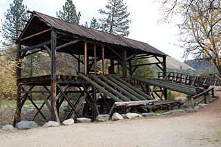
Sutter's Mill was a water-powered sawmill on the bank of the South Fork American River in the foothills of the Sierra Nevada mountains in California. It was named after its owner John Sutter. A worker constructing the mill, James W. Marshall, found gold there in 1848. This discovery set off the California Gold Rush (1848–1855), a major event in the history of the United States.

Mill Valley is a city in Marin County, California, United States, located about 14 miles (23 km) north of San Francisco via the Golden Gate Bridge and 52 miles from Napa Valley. The population was 13,903 at the 2010 census.

Gualala is an unincorporated community in Mendocino County in the U.S. state of California. It is located north of The Sea Ranch and south of Point Arena, California. Gualala shares its southern border with the southern border of Mendocino County. It is located on the Pacific coast at the mouth of the Gualala River, on State Route 1. It serves as a commercial center for the surrounding area. Gualala was once a logging town, but tourism is now its central economic activity.

Samuel P. Taylor State Park is a state park located in Marin County, California. It contains approximately 2,700 acres (11 km2) of redwood forest and grassland. The park contains about 600 acres (2.4 km2) of old-growth forest, some of which can be seen along the Pioneer Tree Trail.
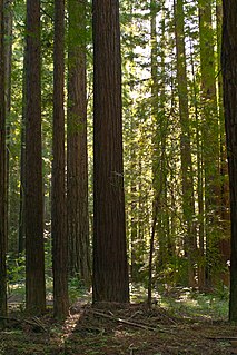
Navarro River Redwoods State Park is a state park in Mendocino County, California, consisting of 660 acres (2.7 km2) of second-growth redwood forest in a narrow stretch 11 miles (18 km) long on both banks of the Navarro River, from the town of Navarro to the river's confluence with the Pacific Ocean.

Garlock is an unincorporated community in Kern County, California. It is located 6.25 miles (10 km) east-southeast of Saltdale, at an elevation of 2169 feet.

Jedediah Smith Redwoods State Park is a state park of California, United States, preserving old-growth redwoods along the Smith River. It is located along U.S. Route 199 approximately 9 miles (14 km) east of Crescent City. The park is named after explorer Jedediah Smith, and is one of four parks cooperatively managed as Redwood National and State Parks. The 10,430-acre (4,220 ha) park was established in 1939 and designated part of the California Coast Ranges International Biosphere Reserve in 1983.

Arroyo Corte Madera del Presidio is a 4.1-mile-long (6.6 km) year-round stream in southern Marin County, California, United States. This watercourse is also known as Corte Madera Creek, although the actual stream of that name flows into San Francisco Bay further north at Point San Quentin. This watercourse has a catchment basin of about 8 square miles (21 km2) and drains the south-eastern slopes of Mount Tamalpais and much of the area in and around the town of Mill Valley; this stream discharges to Richardson Bay.
Rockport is a former settlement in an unincorporated area of Mendocino County, California. It is located 7.25 miles (12 km) north-northwest of Westport, at an elevation of 30 feet.

Clipper Mills is a census-designated place in Butte County, California. It lies at an elevation of 3550 feet. Clipper Mills has a post office, first established in 1861 and moved in 1891. Its zip code is 95930. Clipper Mills's population was 142 at the 2010 census.

Robinson Mill is a census-designated place in Butte County, California. It lies at an elevation of 2654 feet. Robinson Mill's population was 80 at the 2010 census.
Old Bretz Mill is an unincorporated community in Fresno County, California. It is located 2 miles (3.2 km) south-southeast of Shaver Lake Heights, at an elevation of 5823 feet.
Stafford is an unincorporated community in Humboldt County, California. It is located on the south bank of the Eel River 3 miles (4.8 km) southeast of Scotia, at an elevation of 138 feet.
Hobart Mills is a former settlement in Nevada County, California. It is situated at an elevation of 5,880 ft (1,790 m) above sea level.

Andersonia is an unincorporated community in Mendocino County, California. It is located near U.S. Route 101 on the South Fork of the Eel River 1 mile (1.6 km) north-northwest of Piercy, at an elevation of 541 feet.
Hardy is an unincorporated community in Mendocino County, California. It is located on California State Route 1 near the Pacific coast 5.25 miles (8.4 km) north of Westport, at an elevation of 23 feet.
Navarro, formerly known as Wendling, is an unincorporated community in Mendocino County in the U.S. state of California. It is located 18 miles (29 km) west of Ukiah, at an elevation of 269 feet (82 m). It may be reached via east–west California State Route 128, which connects it to the Pacific coast to the west and to the Anderson Valley to the southeast.
Mono Mills is a ghost town in Mono County, California. It is located 9.5 miles (15 km) east-southeast of Lee Vining, at an elevation of 7356 feet. Mono Mills has nearly vanished. Its site is along California State Route 120, 9.1 miles (15 km) east from the junction with U.S. Route 395.
Union Mills is an unincorporated community in Nevada County, California. Union Mills is located in Union Valley, 4.5 miles (7.2 km) east-northeast of Truckee. It lies at an elevation of 5853 feet.
Hughes Mill is an unincorporated community in Placer County, California. Hughes Mill is located 5.25 miles (8.4 km) north-northeast of Foresthill. It lies at an elevation of 3,510 feet.
References
- 1 2 Durham, David L. (1998). California's Geographic Names: A Gazetteer of Historic and Modern Names of the State. Clovis, Calif.: Word Dancer Press. p. 1083. ISBN 1-884995-14-4.

| | This Fresno County, California-related article is a stub. You can help Wikipedia by expanding it. |