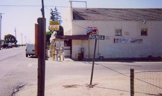
Rolinda is a small unincorporated agricultural community in Fresno County, California, United States. It is located on the Southern Pacific Railroad 10 miles (16 km) west of downtown Fresno, at an elevation of 253 feet. It is located along State Route 180. Official U.S. Geological Survey coordinates for the community are 36°44′07″N119°57′43″W. The community is in area code 559. It does not have its own ZIP code and mail uses the Fresno ZIP code of 93706.

Balch Camp is an unincorporated community in Fresno County, California. It is located near the confluence of the North Fork of the Kings River and Dinkey Creek 38 miles (61 km) east-northeast of Fresno, at an elevation of 1273 feet.
Biola Junction is an unincorporated community in Fresno County, California. It is located on the Southern Pacific Railroad 5.5 miles (9 km) west-northwest of Fresno, at an elevation of 299 feet.

Bronge is a former settlement in Fresno County, California. It was located on the Fresno Interurban Railroad 4.25 miles (6.8 km) south-southeast of Clovis, at an elevation of 338 feet. Bronge still appeared on maps as of 1923.
Camden is an unincorporated community in Fresno County, California. It is located 3.5 miles (5.6 km) east of Riverdale, at an elevation of 236 feet.
Elk is an unincorporated community in Fresno County, California. It is located on the Atchison, Topeka and Santa Fe Railroad 7.25 miles (12 km) southwest of Piedra, at an elevation of 413 feet.
Elm View is an unincorporated community in Fresno County, California. It is located 15 miles (24 km) south of downtown Fresno, at an elevation of 256 feet.
Floyd is an unincorporated community in Fresno County, California. It is located on the Southern Pacific Railroad 11 miles (18 km) west of downtown Fresno, at an elevation of 246 feet.
Fresno Beach is a former settlement in Fresno County, California. It was located at the terminus of a Fresno Traction Company branch line in the Scout Island area 7.5 miles (12 km) north-northwest of downtown Fresno, at an elevation of 262 feet. Fresno Beach still appeared on maps as of 1923.
Glorietta is an unincorporated community in Fresno County, California. It is located on the Southern Pacific Railroad 1 mile (1.6 km) north-northwest of Clovis, at an elevation of 367 feet.
Herndon is an unincorporated community in Fresno County, California. It is located 9 miles (14 km) northwest of downtown Fresno, at an elevation of 299 feet.
Highway City is an unincorporated community in Fresno County, California. It is located 2.5 miles (4 km) southeast of Herndon, at an elevation of 299 feet.
Muscatel is an unincorporated community in Fresno County, California. It is located on the Southern Pacific Railroad 4.5 miles (7.2 km) west-northwest of downtown Fresno, at an elevation of 299 feet.
Nevills is a former settlement in Fresno County, California. It was located on the Southern Pacific Railroad 6.5 miles (10 km) west of downtown Fresno, at an elevation of 262 feet. It still appeared on maps as of 1923.
Riverview is a former settlement in Fresno County, California. It lay at an elevation of 249 feet. It still appeared on maps as of 1923.
Sierra Sky Park is a fly-in unincorporated community in Fresno County, California. It is located 7 miles (11 km) northwest of downtown Fresno, at an elevation of 328 feet.
Westhaven is an unincorporated community in Fresno County, California. It is located 16 miles (26 km) south-southwest of Riverdale, at an elevation of 279 feet.
Andrews is a former settlement in Fresno County, California. It was located on the railroad between Fresno and Figarden. It was located 4 miles (6.4 km) southeast of Figarden; its site is within the modern city limits of Fresno.
Humphreys Station is an unincorporated community in Fresno County, California. It is located 23 miles (37 km) northeast of Fresno.
Kingston is a former settlement, formerly in Fresno County, California. It was located 3.5 miles (5.6 km) west of Laton. Kingston, California is now in Kings County, California. Originally in Fresno County, until 1909 when Fresno County lands in the vicinity, south of the Kings River were transferred to Kings County.


