Coordinates: 36°49′19″N120°30′25″W / 36.82194°N 120.50694°W
A geographic coordinate system is a coordinate system that enables every location on Earth to be specified by a set of numbers, letters or symbols. The coordinates are often chosen such that one of the numbers represents a vertical position and two or three of the numbers represent a horizontal position; alternatively, a geographic position may be expressed in a combined three-dimensional Cartesian vector. A common choice of coordinates is latitude, longitude and elevation. To specify a location on a plane requires a map projection.
Broadview Farms | |
---|---|
Unincorporated community | |
Coordinates: 36°49′19″N120°30′25″W / 36.82194°N 120.50694°W | |
Country | United States |
State | California |
County | Fresno County |
Elevation [1] | 190 ft (58 m) |
Broadview Farms is an unincorporated community in Fresno County, California. [1] It lies at an elevation of 190 feet (58 m). [1]
In law, an unincorporated area is a region of land that is not governed by a local municipal corporation; similarly an unincorporated community is a settlement that is not governed by its own local municipal corporation, but rather is administered as part of larger administrative divisions, such as a township, parish, borough, county, city, canton, state, province or country. Occasionally, municipalities dissolve or disincorporate, which may happen if they become fiscally insolvent, and services become the responsibility of a higher administration. Widespread unincorporated communities and areas are a distinguishing feature of the United States and Canada. In most other countries of the world, there are either no unincorporated areas at all, or these are very rare; typically remote, outlying, sparsely populated or uninhabited areas.
Fresno County, officially the County of Fresno, is a county located in the central portion of the U.S. state of California. As of January 1, 2018, the population was 1,007,229. The county seat is Fresno, the fifth-largest city in California.
California is a state in the Pacific Region of the United States. With 39.6 million residents, California is the most populous U.S. state and the third-largest by area. The state capital is Sacramento. The Greater Los Angeles Area and the San Francisco Bay Area are the nation's second and fifth most populous urban regions, with 18.7 million and 8.8 million residents respectively. Los Angeles is California's most populous city, and the country's second most populous, after New York City. California also has the nation's most populous county, Los Angeles County, and its largest county by area, San Bernardino County. The City and County of San Francisco is both the country's second-most densely populated major city after New York City and the fifth-most densely populated county, behind only four of the five New York City boroughs.
The Yakama Indian Reservation is a Native American reservation in Washington state of the federally recognized tribe the Confederated Tribes and Bands of the Yakama Nation. The tribe is made up of Klikitat, Palus, Wallawalla, Wanapam, Wenatchi, Wishram, and Yakama peoples.
Skógar, literally forests, is a small Icelandic village with a population of roughly 25 located at the south of the Eyjafjallajökull glacier, in the municipality of Rangárþing eystra.
Woodfords is an unincorporated community in Alpine County, California, near Markleeville. For census purposes, it is included in Alpine Village. It is located 6 miles (9.7 km) north-northwest of Markleeville, at 38°46′40″N119°49′19″W.
Cross Roads is an unincorporated community in western Stone County, Missouri, United States. It is located at the intersection of State Routes 173 and 248, approximately four miles west of Galena. Crossroads is part of the Branson, Missouri Micropolitan Statistical Area.
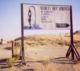
Mercey Hot Springs is an unincorporated community in the Little Panoche Valley of Fresno County, central California, about 60 miles (97 km) west-southwest of Fresno. It is a resort along South Fork Little Panoche Creek and the Little Panoche Road located at the western edge of Fresno County.
Santa Luzia do Norte is a municipality located in the Brazilian state of Alagoas. Its population was 6,759 (2005) and its area is 29 km², which makes it the smallest municipality of Alagoas.
Pacific House is a small unincorporated community in El Dorado County, California, United States. It lies along Highway 50 and is next to the town of Pacific, California. The ZIP code is 95726. The community is inside area code 530.
Puerto Cortés is a small settlement on Isla Santa Margarita, off the Pacific coast of the Mexican state of Baja California Sur. It is part of Comondú Municipality. There is a naval base there. It is sometimes used as a breakpoint in metereological reports. The 2010 census reported no official resident population.
KOKA is a radio station serving the Shreveport-Bossier City metropolitan area with an Urban contemporary gospel format. The station broadcasts on 980 kHz and is currently under ownership of Alpha Media LLC, through licensee Alpha Media Licensee LLC. Its studios are located just north of downtown Shreveport, and the transmitter is just north of Cross Lake.
Ahtanum Ridge is a long anticline mountain ridge in Yakima County in the U.S. state of Washington. It is located just south of the city of Yakima, and much of its length is at the northern edge of the Yakama Indian Reservation.
Arbios is an unincorporated community in Fresno County, California. It is located on the Southern Pacific Railroad 6.5 miles (10 km) south-southeast of Firebaugh, at an elevation of 171 feet.
Cromir is an unincorporated community in Fresno County, California. It is located on the Southern Pacific Railroad 4 miles south-southeast of Firebaugh, at an elevation of 164 feet.
La Jolla Ranch is an unincorporated community in Fresno County, California. It lies at an elevation of 338 feet.
Murietta Farm is an unincorporated community in Fresno County, California. It lies at an elevation of 256 feet.
Ora is an unincorporated community in Fresno County, California, United States. It is located on the Southern Pacific Railroad 2 miles east-northeast of Coalinga, at an elevation of 643 feet .
Westside is an unincorporated community in Fresno County, California. It is located 22 miles (35 km) northeast of Coalinga, at an elevation of 249 feet.
Nopalucan Municipality is a municipality in Puebla in south-eastern Mexico.
Motleys Mill is an unincorporated community in Pittsylvania County, in the U.S. state of Virginia.
San Felipe Creek is a stream in Imperial and San Diego Counties of California. It arises in the Volcan Mountains of San Diego County 33°11′57″N116°37′35″W, and runs eastward, gathering the waters of most of the eastern slope of the mountains and desert of the county before it empties into the Salton Sea. It is probably the last remaining perennial natural desert stream in the Colorado Desert region.
Whites Bridge or Whitesbridge is a former settlement on the Fresno Slough near Tranquillity in Fresno County, California.
This Fresno County, California-related article is a stub. You can help Wikipedia by expanding it. |