
Calaveritas is an unincorporated community in Calaveras County, California. It sits on the banks of the Calaveritas Creek at an elevation of 1,109 feet above sea level and is located at 38°09′29″N120°36′36″W. The community is in ZIP code 95249 and area code 209.
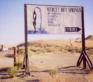
Mercey Hot Springs is an unincorporated community in the Little Panoche Valley of Fresno County, central California, about 60 miles (97 km) west-southwest of Fresno. It is a resort along South Fork Little Panoche Creek and the Little Panoche Road located at the western edge of Fresno County.
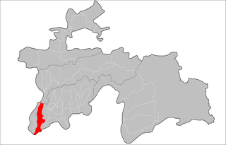
Qabodiyon District or Nohiya-i Qabodiyon is a district in Khatlon province, Tajikistan. Its capital is Qabodiyon.

Masonville is an unincorporated community and a U.S. Post Office in Larimer County, Colorado, United States. The Masonville Post Office has the ZIP Code 80541.

The Baker Way is a footpath running from Chester railway station to Delamere railway station within the English county of Cheshire. The total length of the trail is 13 miles (21 km). Its name commemorates the life and work of Jack Baker, a former footpaths officer for Cheshire County Council.

Lincoln is an unincorporated community in Jackson Township, Cass County, Indiana.

Clear Spring is an unincorporated community in Owen Township, Jackson County, Indiana.

Carvel is a hamlet in Alberta, Canada within Parkland County. It is located on Highway 770, approximately 35 kilometres (22 mi) west of Edmonton. The hamlet's name is derived from the novel Richard Carvel by the American writer Winston Churchill.
Ticktown is an unincorporated community in Accomack County, Virginia.

Greenville is a former settlement in Alameda County, California. It was located 2.5 miles (4.0 km) southwest of Altamont, at an elevation of 584 feet. The name is in honor of John Green, first store owner here.
Big Bar is an unincorporated community in Calaveras County, California. It lies at an elevation of 630 feet.
Nares is a former settlement in Fresno County, California. It was located on the Southern Pacific Railroad 0.5 miles (0.80 km) northwest of Helm, at an elevation of 187 feet. It still appeared on maps as of 1925.
Rancho de los Californios is a former settlement in Fresno County, California. It was located east of Pueblo de las Juntas on high ground near the south bank of the San Joaquin River. Its site is near the corner of Ashlan and North Lake Avenues, 4miles north of the Whitesbridge Road and 6 miles west of Biola, California.
Pelican State Beach is a designated California State Beach located in Del Norte County, California. Located 21 miles (30 km) north of Crescent City on US Route 101 near the town of Smith River, this undeveloped site is immediately south of the Oregon state line, making this site the northernmost California state beach. It is the northern terminus of the California Coastal Trail.
Simeon is an unincorporated community in Cherry County, Nebraska, United States.
Hickory Rock is an unincorporated community in east central Franklin County, North Carolina, United States. It is located at the intersection of Hickory Rock Road and Ronald Tharrington Road, east-northeast of Louisburg, at an elevation of 394 feet.
Beechtree is an unincorporated community in Jefferson County, in the U.S. state of Pennsylvania.
Gale Hills, formerly considered part of the Muddy Range (1879), and later the South Muddy Mountains (1980s), are a range of hills southwest of the Muddy Mountains and about three miles north of the Boulder Basin of Lake Mead, in Clark County, Nevada. It is bounded on the east by Callville Wash; on the south by the Black Mesa lava flows; on the northwest by the valley of Gypsum Wash. Its highpoint is at 36°15′32″N114°43′12″W which lies at 3,756 feet / 1,145 meters.


