The Taupo Volcanic Zone (TVZ) is a volcanic area in the North Island of New Zealand that has been active for the past two million years and is still highly active. Mount Ruapehu marks its south-western end and the zone runs north-eastward through the Taupo and Rotorua areas and offshore into the Bay of Plenty. It is part of the larger Central Volcanic Region that extends further westward through the western Bay of Plenty to the eastern side of the Coromandel Peninsula and has been active for four million years. The Taupo Volcanic Zone is widening east–west at the rate of about 8 mm per year. It is named after Lake Taupo, the flooded caldera of the largest volcano in the zone, the Taupo Volcano.

The Pink Terrace, or Te Otukapuarangi in Māori, and the White Terrace, also known as Te Tarata, were natural wonders of New Zealand. They were reportedly the largest silica sinter deposits on earth. Until recently, they were lost and thought destroyed in the 1886 eruption of Mount Tarawera, while new hydrothermal features formed to the south-west i.e. Waimangu Volcanic Rift Valley.

Rotorua is a city on the southern shores of Lake Rotorua from which the city takes its name, located in the Bay of Plenty Region of New Zealand's North Island. It is the seat of the Rotorua Lakes District, a territorial authority encompassing Rotorua and several other nearby towns. The majority of the Rotorua District is in the Bay of Plenty Region, but a sizeable southern section and a small western section are in the Waikato region. Rotorua is in the heart of the North Island, 60 kilometres south of Tauranga, 80 km (50 mi) north of Taupō, 105 km (65 mi) east of Hamilton, and 230 km (140 mi) southeast of the nation's most populous city, Auckland.
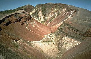
Mount Tarawera is a volcano on the North Island of New Zealand. Located 24 kilometres southeast of Rotorua, it consists of a series of rhyolitic lava domes that were fissured down the middle by an explosive basaltic eruption in 1886. This eruption was one of New Zealand's largest historical eruptions, and killed an estimated 120 people. The fissures run for about 17 kilometres northeast-southwest.

Lake Tikitapu or Blue Lake is the smallest of four small lakes lying between Lake Rotorua and Lake Tarawera in the Bay of Plenty region of New Zealand's North Island. The other three are Lake Rotokakahi, Lake Okareka, and Lake Okataina.

Lake Alexandrina is a lake located in the Mackenzie Basin of New Zealand's South Island. It lies immediately to the west of the much larger Lake Tekapo and further to the east of Lake Pukaki, located to the north of Lake Tekapo township. It is a shallow lake with distinct indications of glacial origin and is spring fed with an outlet on its eastern shore midway down the lake. The outlet feeds into a smaller lake, Lake MacGregor before feeding into Lake Tekapo described as “Opaque and milky blue” in colour. In the desert terrain of the Mackenzie Plains, Lake Alexandrina is considered as an “oasis of life”. Lake Alexandrina is a Wildlife Refuge and a delight to a fisherman, well documented for its brown and rainbow trout and salmon.

Putauaki is a dacite volcanic cone in the Bay of Plenty Region of New Zealand. Located 50 km east of Rotorua and three kilometres east of Kawerau, it is the easternmost vent of the Okataina volcanic centre, within the Taupo Volcanic Zone. The mountain rises to 820 m above sea level, and is visible from the waters of the Bay of Plenty, 30 km to the north. Every year a King of the Mountain race is run on Putauaki as part of the international King of the Mountain series, and proceeds are donated to charity.

Lake Rotokākahi or Green Lake, is one of four small lakes lying between Lake Rotorua and Lake Tarawera in the Bay of Plenty region of New Zealand's North Island. The others are Lake Tikitapu, Lake Okareka, and Lake Okataina. All lie within the Okataina caldera, along its western edge.

Lake Okataina is the northernmost and largest of four smaller lakes lying between Lake Rotorua and Lake Tarawera in the Bay of Plenty region of New Zealand's North Island. The others are Lake Rotokakahi, Lake Tikitapu, and Lake Okareka. All lie within the Okataina caldera, along its western edge.

Lake Rotomahana is an 800-hectare (2,000-acre) lake in northern New Zealand, located 20 kilometres to the south-east of Rotorua. It is immediately south-west of the dormant volcano Mount Tarawera, and its geography was substantially altered by a major 1886 eruption of Mount Tarawera. Along with the mountain, it lies within the Okataina caldera.
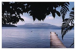
Lake Tarawera is the largest of a series of lakes which surround the volcano Mount Tarawera in the North Island of New Zealand. Like the mountain, it lies within the Okataina caldera. It is located 18 kilometres (11 mi) to the east of Rotorua, and beneath the peaks of the Tarawera massif i.e. Wahanga, Ruawahia, Tarawera and Koa. The lake's surface area is 39 square kilometres (15 sq mi).

Lake Rotorua is the second largest lake in the North Island of New Zealand by surface area, and covers 79.8 km2. With a mean depth of only 10 metres it is considerably smaller than nearby Lake Tarawera in terms of volume of water. It is located in the Bay of Plenty region. The city of Rotorua is sited on its southern shore, and the town of Ngongotahā is at the western edge of the lake.

The Kaituna River is in the Bay of Plenty region of the North Island of New Zealand. It is the outflow from Lakes Rotorua and Rotoiti, and flows northwards for 45 kilometres (28 mi), emptying into the Bay of Plenty near Te Puke. It was the subject of a claim concerning the effluent flowing down the river from Lake Rotorua, which resulted in movement to a land treatment system.
Lake Rotoiti is a lake in the Bay of Plenty region of New Zealand. It is the northwesternmost in a chain of lakes formed within the Okataina caldera. The lake is close to the northern shore of its more famous neighbour, Lake Rotorua, and is connected to it via the Ohau Channel. It drains to the Kaituna River, which flows into the Bay of Plenty near Maketu.

The Trophic State Index (TSI) is a classification system designed to rate water bodies based on the amount of biological productivity they sustain. Although the term "trophic index" is commonly applied to lakes, any surface water body may be indexed.
Ngāti Rangitihi is a Māori iwi of New Zealand, located in the Bay of Plenty.

The Bay of Plenty is a region of New Zealand, situated around a bight of the same name in the northern coast of the North Island. The bight stretches 260 km from the Coromandel Peninsula in the west to Cape Runaway in the east. The Bay of Plenty Region, governed by the Bay of Plenty Regional Council, incorporates several large islands in the bay, in addition to the mainland area. Called Te Moana-a-Toi in the Māori language after Toi, an early ancestor, the name 'Bay of Plenty' was bestowed by James Cook in 1769 when he noticed the abundant food supplies at several Māori villages there, in stark contrast to observations he had made earlier in Poverty Bay.
The trophic level index (TLI) is used in New Zealand as a measure of nutrient status of lakes. It is similar to the trophic state index but was proposed as alternative that suited New Zealand.
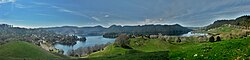
The region around the city of Rotorua, in New Zealand's North Island, contains several lakes. From biggest to smallest, these are Lake Rotorua, Lake Tarawera, Lake Rotoiti, Lake Rotoma, Lake Okataina, Lake Rotoehu, Lake Rotomahana, Lake Rerewhakaaitu, Lake Rotokakahi, Lake Okareka and Lake Tikitapu. There are also four smaller lakes: Lake Okaro/Ngakaro, Lake Rotokawa, Lake Rotokawau and Lake Rotongata. Most of the lakes have formed due to volcanic activity. The region is part of the Taupo Volcanic Zone, the world's most active area of explosive silicic volcanic activity in geologically recent time.

The 1886 eruption of Mount Tarawera occurred in the early hours of 10 June 1886 in the North Island near Rotorua then extended to Waimangu, New Zealand. It is the deadliest eruption in New Zealand since the arrival of Europeans. Around 120 people were killed, and many settlements were destroyed or buried.