Rotorua Lakes

Last updated

Rotorua Lakes, split by a regional boundary Rotorua District.svg
Rotorua Lakes, split by a regional boundary

Rotorua Lakes District, known as Rotorua District from 1979 to 2014, is a territorial authority district in the North Island of New Zealand. It has one urban area of significant size, the city of Rotorua. The district is governed by Rotorua Lakes Council, which is headquartered in Rotorua and is headed by a mayor. The district falls within two regional council areas, with the majority of the area and Rotorua city in the Bay of Plenty region and the rest in the Waikato region. [1] Steve Chadwick has been the mayor of Rotorua since the 2013 local elections.

Contents

History

Rotorua has an unusual history as the town was built by the Government as a tourist destination in the 1880s. [2] Through the Rotorua Borough Act 1922, which achieved royal assent on 28 September 1922, the Rotorua Borough was formed. [3] The inaugural elections for mayor were held in February 1923 and Cecil Clinkard was successful. [4] [5] In 1962, Rotorua was proclaimed a city. [6] In 1979, the status was changed to a district when Rotorua City and Rotorua County amalgamated. [7] The district council held its first meeting on 2 April 1979. [8] At the 27 November 2014 council meeting, it was decided to change the operating name of the district to Rotorua Lakes Council. Since then, the district has been known as Rotorua Lakes and the council's web domain changed from www.rdc.govt.nz to rotorualakescouncil.nz. [9]

Demographics

Historical population
YearPop.±% p.a.
200665,901    
201365,280−0.14%
201871,877+1.94%
Source: [10]

Rotorua District had a population of 71,877 at the 2018 New Zealand census, an increase of 6,597 people (10.1%) since the 2013 census, and an increase of 5,976 people (9.1%) since the 2006 census. There were 25,056 households. There were 35,148 males and 36,729 females, giving a sex ratio of 0.96 males per female. Of the total population, 16,113 people (22.4%) were aged up to 15 years, 14,148 (19.7%) were 15 to 29, 31,248 (43.5%) were 30 to 64, and 10,365 (14.4%) were 65 or older. Figures may not add up to the total due to rounding.

Ethnicities were 63.3% European/Pākehā, 40.1% Māori, 5.4% Pacific peoples, 9.5% Asian, and 1.6% other ethnicities. People may identify with more than one ethnicity.

The percentage of people born overseas was 17.8, compared with 27.1% nationally.

Although some people objected to giving their religion, 49.9% had no religion, 35.0% were Christian, and 8.2% had other religions.

Of those at least 15 years old, 9,876 (17.7%) people had a bachelor or higher degree, and 10,434 (18.7%) people had no formal qualifications. The median income was $28,000. The employment status of those at least 15 was that 27,117 (48.6%) people were employed full-time, 8,541 (15.3%) were part-time, and 3,378 (6.1%) were unemployed. [10]

Geography

Rotorua Lakes covers 2,409 square kilometres (930 sq mi). [11] The district's area is 61.52% in the Bay of Plenty region and 38.48% in the Waikato region. Adjacent districts (in a clockwise direction starting in the north) are Western Bay of Plenty, Whakatāne, Taupo, and South Waikato. [12] [13]

The Bay of Plenty portion of the district includes the settlements of Rotorua, Ngongotahā Valley, Mamaku, Hamurana, Mourea, Rotoiti Forest, Lake Rotoma, Lake Okareka, Lake Tarawera, Rerewhakaaitu, and Kaingaroa Forest. The Waikato portion includes the settlements of Waiotapu, Reporoa, Broadlands, Mihi, Waikite Valley, Ngakuru, and Atiamuri.

Local government

Local council

Every three years, a mayor and the district councillors are elected in local elections. In the most recent elections in 2019, Steve Chadwick was re-elected as mayor and ten councillor were returned. Rotorua Lakes uses the first-past-the-post (FPP) voting system and elects its councillors at-large. [14]

Sister cities

Rotorua has four sister cities: [15]

Related Research Articles

City of Lake Macquarie Local government area in New South Wales, Australia

The City of Lake Macquarie is a local government area in the Hunter Region of New South Wales, Australia and was proclaimed a city from 7 September 1984. The area is situated adjacent to the city of Newcastle and is part of the Greater Newcastle Area. The city is approximately 150 km (93 mi) north of Sydney. One of its major tourist attractions is its lake, also named Lake Macquarie.

Waikato Region of New Zealand

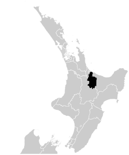
Waikato is a local government region of the upper North Island of New Zealand. It covers the Waikato District, Waipa District, Matamata-Piako District, South Waikato District and Hamilton City, as well as Hauraki, Coromandel Peninsula, the northern King Country, much of the Taupō District, and parts of Rotorua District. It is governed by the Waikato Regional Council.

Rotorua City in Bay of Plenty, New Zealand

Rotorua is a city on the southern shores of Lake Rotorua from which the city takes its name, located in the Bay of Plenty Region of New Zealand's North Island. It is the seat of the Rotorua Lakes District, a territorial authority encompassing Rotorua and several other nearby towns. The majority of the Rotorua District is in the Bay of Plenty Region, but a sizeable southern section and a small western section are in the Waikato region. Rotorua is in the heart of the North Island, 60 kilometres south of Tauranga, 80 km (50 mi) north of Taupō, 105 km (65 mi) east of Hamilton, and 230 km (140 mi) southeast of the nation's most populous city, Auckland.

Hauraki District Territorial authority in Waikato, New Zealand

Hauraki District is a territorial authority within the Waikato region of New Zealand. The seat of the council is at Paeroa.

Waikato District Territorial authority in Waikato, New Zealand

Waikato District is a territorial authority of New Zealand, in the northern part of Waikato region, North Island. Waikato District is administered by the Waikato District Council, with headquarters in Ngāruawāhia.

South Waikato District Territorial authority in Waikato, New Zealand

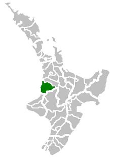
South Waikato District is a local government district in the Waikato Region of the North Island of New Zealand. It is located between the cities of Hamilton to the north, Rotorua to the east, Taupō to the south and Ruapehu District to the west.

Waitomo District Territorial authority in Waikato region, New Zealand

Waitomo District is a territorial authority, located in the Waikato region, at the north of the King Country area in the North Island of New Zealand. A small part of the district, the town of Tiroa, however, lies in the Manawatū-Whanganui region.

Western Bay of Plenty District Territorial authority in Bay of Plenty, New Zealand

Western Bay of Plenty District is a territorial authority within the Bay of Plenty Region of New Zealand. The district envelops Tauranga City by land, and includes Matakana Island, at the entrance to Tauranga Harbour.

Southland District Territorial authority in Southland Region, New Zealand

Southland District is a New Zealand territorial authority that covers the south of the South Island as well as Stewart Island/Rakiura.

Steve Chadwick New Zealand politician

Stephanie Anne "Steve" Chadwick is a New Zealand politician. She became the Mayor of Rotorua after her election victory in the 2013 local body elections. She previously held the positions of Minister of Conservation, Women's Affairs, and Associate Health in the Fifth Labour Government of New Zealand.

Rangitikei District Territorial authority in Manawatū-Whanganui, New Zealand

The Rangitikei District is a territorial authority located primarily in the Manawatū-Whanganui region in the North Island of New Zealand, although a small part, the town of Ngamatea, lies in the Hawke's Bay Region. It is located in the southwest of the island, and follows the catchment area of the Rangitikei River.

The Taupo District Council is a territorial authority that administers the Taupo District in the Central North Island of New Zealand. The district stretches from the small town of Mangakino in the northwest to the Tongariro National Park in the south, and east into the Kaingaroa Forest, covering 6,970 km2. It had a population of 39,300 as of June 2019.

Rotorua (New Zealand electorate) New Zealand parliamentary electorate

Rotorua is a New Zealand parliamentary electorate, returning one Member of Parliament to the New Zealand House of Representatives. It was first established in 1919, and has existed continuously since 1954. The current MP for Rotorua is Todd McClay of the National Party, who won the electorate in the 2008 general election from incumbent Labour MP Steve Chadwick.

Districts of New Zealand district administered by a territorial authority in New Zealand

A district in New Zealand is a territorial authority area governed by a district council as a second-tier of local government in New Zealand, below regional councils. They were formed as a result of local government reforms in 1989. There are 53 districts in New Zealand, and they do not include the 12 city councils, Auckland Council, or Chatham Islands Council. District councils serve a combination of rural and urban communities, while city councils administer the larger urban areas. Three districts are unitary authorities also performing the functions of a regional council.

Bay of Plenty Region of New Zealand

The Bay of Plenty is a region of New Zealand, situated around a bight of the same name in the northern coast of the North Island. The bight stretches 260 km from the Coromandel Peninsula in the west to Cape Runaway in the east. The Bay of Plenty Region, governed by the Bay of Plenty Regional Council, incorporates several large islands in the bay, in addition to the mainland area. Called Te Moana-a-Toi in the Māori language after Toi, an early ancestor, the name 'Bay of Plenty' was bestowed by James Cook in 1769 when he noticed the abundant food supplies at several Māori villages there, in stark contrast to observations he had made earlier in Poverty Bay.

Cecil Clinkard New Zealand politician

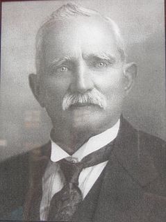
Cecil Henry Clinkard was a United Party Member of Parliament in New Zealand, and the first Mayor of Rotorua.

Ōtorohanga District Territorial authority in Waikato, New Zealand

Ōtorohanga District is a territorial municipality in the King Country area and Waikato region of the North Island of New Zealand. It is a mostly rural area, with Otorohanga town being by far the biggest urban area, with a population nearing 3,000. The District was called Otorohanga County from 1971 to 1979.

Gore District, New Zealand Territorial authority in Southland, New Zealand

Gore District is a district in the Southland region of the South Island of New Zealand.

Tauranga Port city in the Bay of Plenty in the North Island of New Zealand

Tauranga is a coastal metropolitan city in the Bay of Plenty region and the fifth most populous city of New Zealand, with an urban population of 135,000. It was settled by Māori late in the 13th century, by Europeans in the early 19th century, and was constituted as a city in 1963.

Mayor of Rotorua Wikimedia list article

The Mayor of Rotorua officiates over the Rotorua Lakes district of New Zealand, which is administered by the Rotorua Lakes Council (RLC), whose seat is in Rotorua. An elected borough council first came together in February 1923; prior to that, the area had effectively been under government control. Rotorua has had 14 mayors so far, and the current mayor is Steve Chadwick.

References

  1. "About the Rotorua District". Rotorua Lakes Council. 3 July 2019. Retrieved 20 May 2020.
  2. "Rotorua". Ministry for Culture and Heritage . Retrieved 13 May 2020.
  3. "Rotorua Borough Act 1922". Parliamentary Counsel Office . Retrieved 13 May 2020.
  4. "Cecil Clinkard". Rotorua District Library. Retrieved 13 May 2020.
  5. "Mayor of Rotorua". Auckland Star . 28 February 1923. p. 3. Retrieved 13 May 2020.
  6. McKinnon, Malcolm (25 May 2015). "Volcanic Plateau places - Rotorua city". Te Ara: The Encyclopedia of New Zealand . Retrieved 13 May 2020.
  7. "John Keaney, CBE QSO". Rotorua District Library. Retrieved 13 May 2020.
  8. "Coat of Arms". Rotorua Lakes Council. Retrieved 13 May 2020.
  9. "District council becomes Rotorua Lakes Council" (Press release). Rotorua: Rotorua Lakes Council. 1 December 2014. Retrieved 13 May 2020.
  10. 1 2 "Statistical area 1 dataset for 2018 Census". Statistics New Zealand. March 2020. Rotorua District (024). 2018 Census place summary: Rotorua District
  11. "Rotorua District Council". Department of Internal Affairs . Retrieved 13 May 2020.
  12. "Waikato Regional Council". Department of Internal Affairs . Retrieved 13 May 2020.
  13. "Bay Of Plenty". Department of Internal Affairs . Retrieved 13 May 2020.
  14. Lampp, Warwick (17 October 2019). "Rotorua Lakes Council – 2019 Triennial Elections – Declaration of Results" (PDF). Rotorua Lakes Council. Retrieved 14 May 2020.
  15. "Rotorua Sister Cities". Rotorua Lakes Council. 20 November 2019. Retrieved 14 May 2020.