Reporoa | |
---|---|
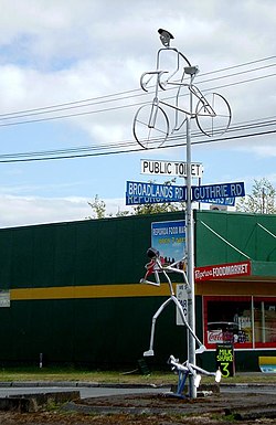
![]() Road sign and sculpture | |
![]() | |
Coordinates: 38°26′10″S176°20′27″E / 38.436003°S 176.340785°E | |
Country | New Zealand |
Region | Waikato |
Territorial authority | Rotorua Lakes District |
Ward | Rotorua Rural General Ward |
Community | Rotorua Rural Community |
Electorates | |
Government | |
• Territorial authority | Rotorua Lakes Council |
• Regional council | Waikato Regional Council |
Area | |
• Total | 15.67 km2 (6.05 sq mi) |
Population (2018 Census) [2] | |
• Total | 279 |
• Density | 18/km2 (46/sq mi) |
Reporoa is a rural community in Rotorua Lakes within the Waikato region of New Zealand's North Island.
It is located within the Reporoa Caldera, [3] a caldera in the Taupo Volcanic Zone containing the Deer Hill, Kairuru and Pukekahu rhyolitic lava domes and the active Reporoa geothermal field. [4] [5] Several hydrothermal explosions have occurred in the area, with a large one being recorded in 1948, and another large one occurring in a cow paddock in April 2005. [6]
The New Zealand Ministry for Culture and Heritage gives a translation of "long swamp" for Reporoa. [7]
Reporoa is in two SA1 statistical areas which cover 15.67 km2 (6.05 sq mi). [1] The SA1 areas are part of the Golden Springs statistical area.
Year | Pop. | ±% p.a. |
---|---|---|
2006 | 330 | — |
2013 | 279 | −2.37% |
2018 | 279 | +0.00% |
Source: [2] |
Reporoa had a population of 279 at the 2018 New Zealand census, unchanged since the 2013 census, and a decrease of 51 people (−15.5%) since the 2006 census. There were 99 households, comprising 141 males and 138 females, giving a sex ratio of 1.02 males per female, with 69 people (24.7%) aged under 15 years, 60 (21.5%) aged 15 to 29, 126 (45.2%) aged 30 to 64, and 24 (8.6%) aged 65 or older.
Ethnicities were 63.4% European/Pākehā, 51.6% Māori, 5.4% Pacific peoples, and 4.3% Asian. People may identify with more than one ethnicity.
Although some people chose not to answer the census's question about religious affiliation, 57.0% had no religion, 30.1% were Christian, 4.3% had Māori religious beliefs, 2.2% were Hindu and 2.2% had other religions.
Of those at least 15 years old, 9 (4.3%) people had a bachelor's or higher degree, and 57 (27.1%) people had no formal qualifications. 21 people (10.0%) earned over $70,000 compared to 17.2% nationally. The employment status of those at least 15 was that 108 (51.4%) people were employed full-time, 33 (15.7%) were part-time, and 24 (11.4%) were unemployed. [2]
Golden Springs statistical area covers 498.92 km2 (192.63 sq mi) [1] and had an estimated population of 1,960 as of June 2023, [8] with a population density of 3.9 people per km2.
Year | Pop. | ±% p.a. |
---|---|---|
2006 | 1,764 | — |
2013 | 1,797 | +0.27% |
2018 | 1,767 | −0.34% |
Source: [9] |
Golden Springs had a population of 1,767 at the 2018 New Zealand census, a decrease of 30 people (−1.7%) since the 2013 census, and an increase of 3 people (0.2%) since the 2006 census. There were 609 households, comprising 939 males and 831 females, giving a sex ratio of 1.13 males per female. The median age was 31.6 years (compared with 37.4 years nationally), with 468 people (26.5%) aged under 15 years, 366 (20.7%) aged 15 to 29, 810 (45.8%) aged 30 to 64, and 123 (7.0%) aged 65 or older.
Ethnicities were 80.0% European/Pākehā, 29.9% Māori, 2.9% Pacific peoples, 4.9% Asian, and 1.5% other ethnicities. People may identify with more than one ethnicity.
The percentage of people born overseas was 12.4, compared with 27.1% nationally.
Although some people chose not to answer the census's question about religious affiliation, 59.8% had no religion, 26.1% were Christian, 2.5% had Māori religious beliefs, 0.7% were Hindu, 0.2% were Muslim, 0.5% were Buddhist and 2.4% had other religions.
Of those at least 15 years old, 165 (12.7%) people had a bachelor's or higher degree, and 258 (19.9%) people had no formal qualifications. The median income was $39,800, compared with $31,800 nationally. 225 people (17.3%) earned over $70,000 compared to 17.2% nationally. The employment status of those at least 15 was that 771 (59.4%) people were employed full-time, 216 (16.6%) were part-time, and 39 (3.0%) were unemployed. [9]
The Reporoa area has four Ngāti Tahu – Ngāti Whaoa marae:
Reporoa College is a co-educational state secondary school for Year 7 to 13 schools, [12] [13] with a roll of 163 as of February 2024. [14]
Reporoa also has two primary schools for Year 1 to 6 students: Reporoa School, [15] with a roll of 102; [16] and Broadlands School, [17] [18] with a roll of 78. [19]
Te Kūiti is a town in the north of the King Country region of the North Island of New Zealand. It lies at the junction of State Highways 3 and 30 and on the North Island Main Trunk railway, 80 kilometres (50 mi) south of Hamilton. The town promotes itself as the sheep shearing capital of the world and is host to the annual New Zealand National Shearing Championships.
Whakatāne is a town located in the Bay of Plenty Region in the North Island of New Zealand, 90 kilometres (56 mi) east of Tauranga and 89 kilometres (55 mi) northeast of Rotorua. The town is situated at the mouth of the Whakatāne River. The Whakatāne District is the territorial authority that encompasses the town, covering an area to the south and west of the town, excluding the enclave of Kawerau District.
Tūrangi is a small town on the west bank of the Tongariro River, 50 kilometres south-west of Taupō on the North Island Volcanic Plateau of New Zealand. It was built to accommodate the workers associated with the Tongariro hydro-electric power development project and their families. The town was designed to remain as a small servicing centre for the exotic forest plantations south of Lake Taupō and for tourists. It is well known for its trout fishing and calls itself "the trout fishing capital of the world". The major Māori hapū (tribe) of the Tūrangi area is Ngāti Tūrangitukua.
Tokomaru Bay is a small beachside community on the remote East Coast of New Zealand's North Island. It is 91 km north of Gisborne, on State Highway 35, and close to Mount Hikurangi. The district was originally known as Toka-a-Namu, which refers to the abundance of sandflies. Over the years the name was altered to Tokomaru Bay.
Murupara is a town in the Whakatāne District and Bay of Plenty Region of New Zealand's North Island. The town is in an isolated part of the region between the Kaingaroa Forest and Te Urewera protected area, on the banks of the Rangitaiki River, 65 kilometres southeast of Rotorua. Indigenous Māori also make up over 90% of the population.
Tolaga Bay is both a bay and small town on the East Coast of New Zealand's North Island located 45 kilometres northeast of Gisborne and 30 kilometres south of Tokomaru Bay.
Clive is a small town, ten kilometres from the city centres of both Napier and Hastings in the Hawke's Bay region of New Zealand's North Island. It is close to the mouth of the Ngaruroro River.
Ōtaki is a town in the Kāpiti Coast District of the North Island of New Zealand, situated half way between the capital city Wellington, 70 km (43 mi) to the southwest, and Palmerston North, 70 km (43 mi) to the northeast.
Nukuhau is a suburb of Taupō in the Waikato Region of New Zealand's North Island.
Kuratau is a small village north of Pukawa, on the western side of New Zealand's Lake Taupō.
Kaiti is a suburb of the New Zealand city of Gisborne. It is located immediately to the east of the city centre, on the opposing bank of the Waimata River.
Piopio is a small town in the Waitomo District. It is situated on State Highway 3 approximately 23 km from Te Kūiti.
Mokai is a rural community in the Taupō District and Waikato region of New Zealand's North Island.
Waimana is a rural valley in the Whakatāne District and Bay of Plenty Region of New Zealand's North Island. It is located in the northern Te Urewera. Waimana River, originally known as Tauranga River, runs through the valley, joining the Ohinemataroa River one kilometre south-west of Tāneatua.
Rotoiti is a settlement on the shore of Lake Rotoiti, in Rotorua Lakes within the Bay of Plenty Region of New Zealand's North Island.
Lynmore is a suburb of Rotorua in the Bay of Plenty Region of New Zealand's North Island.
Ōwhata is a semi-rural suburb of Rotorua in the Bay of Plenty region of New Zealand's North Island.
Waipahihi is a suburb in Taupō, based on the eastern shores of Lake Taupō on New Zealand's North Island.
Taupō Central is the central suburb and business district of Taupō in the Waikato region of New Zealand's North Island.
Kaingaroa, also called Kaingaroa Forest or Kaingaroa Village, is a small town southeast of Rotorua within the Bay of Plenty region of New Zealand's North Island. The town is the headquarters of Kaingaroa Forest.