Related Research Articles
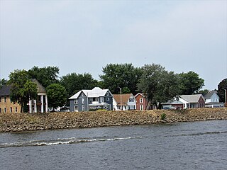
Sabula is a city in Jackson County, Iowa, United States. The population was 506 at the 2020 census. Sabula is the site of Iowa's only island city. The island has a beach and a campground, as well as a harbor with boat docks and storage sheds to store boats during the winter. Because of its proximity to Chicago, Sabula has become a popular vacation destination during the summer months. Sabula is the northern terminus of U.S. Route 67, a 1,560 mile (2,511 km) long north–south highway in the Central United States. The southern terminus of the route is at the United States–Mexico border in Presidio, Texas.
Sandy Township is a township in Saint Louis County, Minnesota, United States. The population was 356 at the 2010 census.

Sandy Township is a township in Clearfield County, Pennsylvania, United States. The population was 11,852 at the 2020 census.

Sandy is a city in the Salt Lake City metropolitan area, located in Salt Lake County, Utah, United States. The population is currently estimated to be about 96,380 according to the July 1, 2019 United States Census estimates.

The Huron–Manistee National Forests are two separate national forests, the Huron National Forest and the Manistee National Forest, combined in 1945 for administration purposes and which comprise 978,906 acres (3,960 km2) of public lands, including 5,786 acres (23 km2) of wetlands, extending across the northern lower peninsula of Michigan. The Huron–Manistee National Forests provide recreation opportunities for visitors, habitat for fish and wildlife, and resources for local industry. The headquarters for the forests is in Cadillac, Michigan.

Joseph Hopkins Millard was a Canadian-American businessman and politician from Nebraska. He served in the United States Senate and as mayor of Omaha, and was an anti-suffrage activist.

The Savanna–Sabula Bridge was a truss bridge and causeway crossing the Mississippi River that connected the city of Savanna, Illinois, with the island city of Sabula, Iowa. The bridge was put out of service on November 17, 2017, when its replacement, which lies a few dozen feet downstream, opened as the Dale Gardner Veterans Memorial Bridge. The bridge carried U.S. Route 52 over the river. It was also the terminus of both Iowa Highway 64 and Illinois Route 64. The bridge carried an average of 2,170 vehicles daily as of 2015, with 6% of that being truck traffic.
America First Field is an American soccer-specific stadium in Sandy, Utah, that serves as home stadium for Major League Soccer club Real Salt Lake and National Women's Soccer League club Utah Royals. The stadium opened on October 9, 2008, and seats 20,213 for soccer, but can be expanded to over 25,000 for concerts.

Iowa Highway 64 (Iowa 64) is a 64-mile-long (103 km) state highway that runs through two counties in east central Iowa. It begins at an interchange with U.S. Route 151 (US 151) in Anamosa and ends at the Dale Gardner Veterans Memorial Bridge over the Mississippi River near Sabula. It continues through Illinois as Illinois Route 64. The western half of the highway is the Grant Wood Scenic Byway. Originally, Iowa 64 spanned the length of the state and began at the Missouri River in Council Bluffs where it connected to N-64 in Omaha. It headed northeast and east on highways that today are roughly parallel to Interstate 80 (I-80) and US 30. In 1969, however, Iowa 64 was shortened to its current routing.

The Sandy Lake Tragedy was the culmination in 1850 of a series of events centered in Big Sandy Lake, Minnesota that resulted in the deaths of several hundred Lake Superior Chippewa. Officials of the Zachary Taylor Administration and Minnesota Territory sought to relocate several bands of the tribe to areas west of the Mississippi River. By changing the location for fall annuity payments, the officials intended the Chippewa to stay at the new site for the winter, hoping to lower their resistance to relocation. Due to delayed and inadequate payments of annuities and lack of promised supplies, about 400 Ojibwe, mostly men and 12% of the tribe, died of disease, starvation and cold. The outrage increased Ojibwe resistance to removal. The bands effectively gained widespread public support to achieve permanent reservations in their traditional territories.

Sandy Lick Creek is a tributary of Redbank Creek in northwest Pennsylvania in the United States.

U.S. Highway 52 is a 166-mile-long (267 km) United States Numbered Highway in northeast Iowa. The route begins at the Dale Gardner Veterans Memorial Bridge over the Mississippi River between Sabula and Savanna, Illinois. From Sabula, it heads north along the Mississippi towards Bellevue and Dubuque. At Dubuque, US 52 briefly shares an expressway with US 61 and US 151 before joining the Southwest Arterial, another expressway diverting traffic around the southern edge of Dubuque.
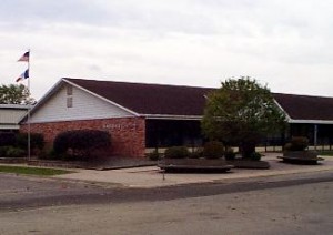
Marquette High School is a private, Roman Catholic high school located in Bellevue, Iowa, United States. It is in the Roman Catholic Archdiocese of Dubuque.
Britt is an unincorporated area in Saint Louis County, Minnesota, United States.
Sandy Lake is an unincorporated community Native American village located in Turner Township, Aitkin County, Minnesota, United States. Its name in the Ojibwe language is Gaa-mitaawangaagamaag, meaning "Place of the Sandy-shored Lake". The village is administrative center for the Sandy Lake Band of Mississippi Chippewa, though the administration of the Mille Lacs Indian Reservation, District II, is located in the nearby East Lake.
Osoyoos Lake State Park was a Washington state park in Okanogan County until it was sold to the city of Oroville and renamed Osoyoos Lake Veteran’s Memorial Park. The park has a 300-foot (91 m) sandy beach on Osoyoos Lake, boat ramp, and campground.

Lucky Peak State Park is a public recreation area covering a total of 240 acres (97 ha) on and near Lucky Peak Lake approximately ten miles (16 km) east of Boise in Ada County, Idaho. The state park has three units: Discovery Park off State Highway 21, a roadside park for picnicking and fishing in the Boise River; Sandy Point at the base of the Lucky Peak Dam, with sandy beach and calm waters for wading and swimming; and the Spring Shores unit with boat ramps and marina at the northern end of the lake. The park was created in 1956 by agreement with the United States Army Corps of Engineers, following completion of the Lucky Peak Dam. The park is also home to the Lucky Peak Dam Zeolite Occurrence.
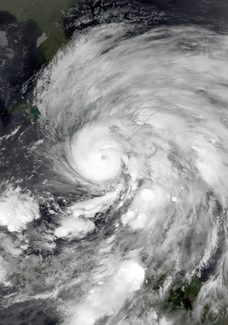
Hurricane Sandy was an extremely large and destructive Category 3 Atlantic hurricane which ravaged the Caribbean and the coastal Mid-Atlantic region of the United States in late October 2012. It was the largest Atlantic hurricane on record as measured by diameter, with tropical-storm-force winds spanning 1,150 miles (1,850 km). The storm inflicted nearly $70 billion in damage and killed 233 people across eight countries from the Caribbean to Canada. The eighteenth named storm, tenth hurricane, and second major hurricane of the 2012 Atlantic hurricane season, Sandy was a Category 3 storm at its peak intensity when it made landfall in Cuba, though most of the damage it caused was after it became a Category 1-equivalent extratropical cyclone off the coast of the Northeastern United States.

The Jeremiah Wood House is a historic residence located in Sabula, Iowa, United States. The house is associated with the settlement of Sabula, and the occupation of steamboat pilot. Dr. Enoch A. Wood and his father James settled here in 1836 and platted the town the same year. It was named Sabula ten years later. Enoch's brother Jeremiah joined them in 1837, and worked in the family retail store. He became a steamboat pilot around 1852, and married his wife in 1860. He built the major part of this house six years later. The 2½-story stone house was built on the banks of the Mississippi River. It features modillions along the rooflines, ocular windows on the gable ends, and a two-story porch on the main facade. The back wing may be as much as 30 years older. The house was listed on the National Register of Historic Places in 1982.
East Central Community School District was a school district in Iowa with campuses in Miles and Sabula.
References
Municipalities and communities of Clearfield County, Pennsylvania, United States | ||
|---|---|---|
| City |  | |
| Boroughs | ||
| Townships | ||
| CDPs | ||
| Unincorporated communities |
| |
| Footnotes | ‡This populated place also has portions in an adjacent county or counties | |
| | This Clearfield County, Pennsylvania state location article is a stub. You can help Wikipedia by expanding it. |