
Tsing Ma Bridge is a bridge in Hong Kong. It is the world's 17th-longest span suspension bridge,and was the second longest at the time of its completion. The bridge was named after the two islands it connects,namely Tsing Yi and Ma Wan. It has two decks and carries both road and rail traffic,which also makes it the largest suspension bridge of this type. The bridge has a main span of 1,377 metres (4,518 ft) and a height of 206 metres (676 ft). The span is the longest of all bridges in the world carrying rail traffic.

Tsing Yi,sometimes referred to as Tsing Yi Island,is an island in the New Territories of Hong Kong,to the northwest of Hong Kong Island and south of Tsuen Wan. With an area of 10.69 km2 (4.13 sq mi),the island has been extended drastically by reclamation along almost all its natural shore and the annexation of Nga Ying Chau (牙鷹洲) and Chau Tsai. Three major bays or harbours,Tsing Yi Lagoon,Mun Tsai Tong,and Tsing Yi Bay (青衣灣) in the northeast,have been completely reclaimed for new towns.

Tung Chung,meaning "eastern stream",is an area on the northwestern coast of Lantau Island,Hong Kong. One of the most recent new towns,it was formerly a rural fishing village beside Tung Chung Bay,and along the delta and lower courses of Tung Chung River and Ma Wan Chung in the north-western coast of Lantau Island. The area was once an important defence stronghold against pirates and foreign military during the Ming and the Qing dynasties.
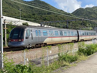
The Tung Chung line is one of the ten lines of the MTR system in Hong Kong,linking the town of Tung Chung with central Hong Kong. It was built in the 1990s as part of the Airport Railway project,part of the construction of the new Chek Lap Kok Airport. The line currently travels through eight stations in 31 minutes along its route. The line is coloured orange on the MTR system map.
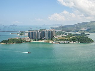
Ma Wan is an island of Hong Kong,located between Lantau Island and Tsing Yi Island,with an area of 0.97 square kilometres. Administratively,it is part of Tsuen Wan District.

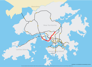
The Lantau Link,formerly known as the Lantau Fixed Crossing,is a roadway in Hong Kong forming part of Route 8 linking Lantau Island to Tsing Yi,from which other roads lead to the urban areas of Kowloon and the rest of the New Territories. It is part of the Airport Core Programme centred on the new Hong Kong International Airport on Lantau. The link was officially opened on 27 April 1997,and it opened to traffic on 22 May the same year.

The Airport Express is one of the ten rail lines of the Hong Kong MTR system. It links the urban area with Hong Kong International Airport and the AsiaWorld–Expo exhibition and convention centre.

Route 8 of Hong Kong is a dual 3-lane carriageway motorway that links Lantau Island,Tsing Yi Island,Cheung Sha Wan in West Kowloon,and Sha Tin in the southeast New Territories of Hong Kong. It is a combination of many sections.
Tsing Yi North Bridge,also called Tsing Tsuen Bridge (青荃橋),connects the Tam Kon Shan Interchange on Tsing Yi Island to the Tsuen Tsing Interchange in Tsuen Wan,spanning the Rambler Channel. Inaugurated on 10 December 1987,the bridge was designed to improve access to Tsing Yi,which at that time was connected to Kwai Chung by only one fixed link,the heavily congested Tsing Yi Bridge.
Tsing Yi North Coastal Road,also abbreviated as TYNCR,is a dual carriageway in Tsing Yi,Hong Kong. The road starts at Tsing Tsuen Road,where it travels through the northern part of the island. It ends at Route 3 and Route 8 on the western side of the island at a left-in/left-out interchange,2.2 kilometres (1.4 mi) from its eastern terminus. The road was first planned in 1998 to relieve traffic coming from Lantau. It was constructed in 1999,and was opened on 2 February 2002.

The Airport Core Programme was a series of infrastructure projects centred on the new Hong Kong International Airport during the early 1990s. The programme was part of the Port and Airport Development Strategy,commonly known as the Rose Garden Project.

The Airport Core Programme Exhibition Centre is housed in a single-storey distinctive white structure situated at 401 Castle Peak Road,Ting Kau,New Territories in Hong Kong. The exhibition centre is run by the Home Affairs Department for the Airport Core Programme,often referred to as the Rose Garden Project.

Tung Chung New Town,formerly named North Lantau New Town,is the newest of the nine new towns in Hong Kong,a special administrative region of China,located on the northern coast of the Lantau Island in the New Territories. It covers Tung Chung,Tai Ho Wan,Siu Ho Wan,other parts of northeast Lantau Island,and the reclaimed land along the coast between them. It is the only new town in the Islands District and the youngest new town in Hong Kong. As the commercial,residential and community facilities in the New Town are concentrated in Tung Chung,it has been renamed Tung Chung New Town in recent official government documents.
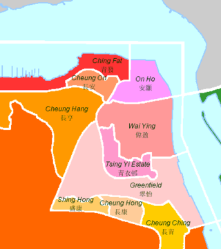
The following is an overview of public housing estates on Tsing Yi,Hong Kong including Home Ownership Scheme (HOS),Private Sector Participation Scheme (PSPS),Flat-for-Sale Scheme (FFSS),Tenant Purchase Scheme (TPS) and Subsidised Sale Flats Project (SSFP) estates.

Autotoll Limited provides electronic toll collection (ETC) service in Hong Kong.
Tsing Sha Highway is a major expressway in Hong Kong,which links the island of Tsing Yi to Sha Tin. The road is part of Route 8,which starts in Sha Tin and terminates in Tung Chung. It was opened in March 2008 and extended in December 2009.

The Jiangong Islet is a tidal island in Jincheng Township,Kinmen County,Fujian Province,Republic of China (Taiwan).
Scenic Hill Tunnel is a road tunnel located on the Hong Kong–Zhuhai–Macau Bridge,in Scenic Hill,Chek Lap Kok,Lantau Island,Hong Kong. The west exit of the tunnel is near the Ngong Ping 360 Airport Island Angle Station and the fuel storage centre. It runs through Scenic Hill and along the current Airport Road and under the MTR Airport Express lines,and passes through the new reclamation areas,connecting the Hong Kong road sections and the Hong Kong–Zhuhai–Macau Bridge port.

Texaco Road is a road in Tsuen Wan,New Territories,Hong Kong. It connects the Tsuen Kam Interchange with Ma Tau Pa Road and Wing Shun Street,intersecting with both the Tsuen Tsing Interchange and Castle Peak Road. Texaco Road,the first internal road in Tsuen Wan,was constructed in the 1930s to facilitate the industrial development of the Texaco Fuel Company at Cape Tsing Yi Bay and was later renovated in 1959. The section of Texaco Road north of Castle Peak Road was constructed later and opened on March 31,1981;this section is now referred to as Texaco Road North,and the Texaco Interchange,where Texaco Road intersects Castle Peak Road,was inaugurated on the same day.
