
Wind tunnels are machines where an object is held stationary inside a tube, and air is blown around it to study the interaction between the object and the moving air. They are used to test the aerodynamic effects of aircraft, rockets, cars, and buildings. Different wind tunnels range in size from less than a foot across, to over 100 feet (30 m), and can have air that moves at speeds from a light breeze to hypersonic velocities.

A parabolic antenna is an antenna that uses a parabolic reflector, a curved surface with the cross-sectional shape of a parabola, to direct the radio waves. The most common form is shaped like a dish and is popularly called a dish antenna or parabolic dish. The main advantage of a parabolic antenna is that it has high directivity. It functions similarly to a searchlight or flashlight reflector to direct radio waves in a narrow beam, or receive radio waves from one particular direction only. Parabolic antennas have some of the highest gains, meaning that they can produce the narrowest beamwidths, of any antenna type. In order to achieve narrow beamwidths, the parabolic reflector must be much larger than the wavelength of the radio waves used, so parabolic antennas are used in the high frequency part of the radio spectrum, at UHF and microwave (SHF) frequencies, at which the wavelengths are small enough that conveniently sized reflectors can be used.

A spirit level, bubble level, or simply a level, is an instrument designed to indicate whether a surface is horizontal (level) or vertical (plumb). Two basic designs exist: tubular and bull's eye . Different types of spirit levels may be used by carpenters, stonemasons, bricklayers, other building trades workers, surveyors, millwrights and other metalworkers, and in some photographic or videographic work.

Synthetic-aperture radar (SAR) is a form of radar that is used to create two-dimensional images or three-dimensional reconstructions of objects, such as landscapes. SAR uses the motion of the radar antenna over a target region to provide finer spatial resolution than conventional stationary beam-scanning radars. SAR is typically mounted on a moving platform, such as an aircraft or spacecraft, and has its origins in an advanced form of side looking airborne radar (SLAR). The distance the SAR device travels over a target during the period when the target scene is illuminated creates the large synthetic antenna aperture. Typically, the larger the aperture, the higher the image resolution will be, regardless of whether the aperture is physical or synthetic – this allows SAR to create high-resolution images with comparatively small physical antennas. For a fixed antenna size and orientation, objects which are further away remain illuminated longer - therefore SAR has the property of creating larger synthetic apertures for more distant objects, which results in a consistent spatial resolution over a range of viewing distances.

An inclinometer or clinometer is an instrument used for measuring angles of slope, elevation, or depression of an object with respect to gravity's direction. It is also known as a tilt indicator, tilt sensor, tilt meter, slope alert, slope gauge, gradient meter, gradiometer, level gauge, level meter, declinometer, and pitch & roll indicator. Clinometers measure both inclines and declines using three different units of measure: degrees, percentage points, and topos. The astrolabe is an example of an inclinometer that was used for celestial navigation and location of astronomical objects from ancient times to the Renaissance.
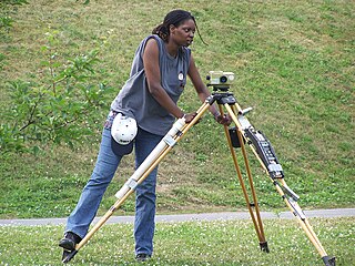
Levelling or leveling is a branch of surveying, the object of which is to establish or verify or measure the height of specified points relative to a datum. It is widely used in geodesy and cartography to measure vertical position with respect to a vertical datum, and in construction to measure height differences of construction artifacts.

A wiggler, also known as a wobbler, edge-finder, center-finder or laser-centering-device, is a tool used with a machine like a mill, to accurately align the machine head with the work prior to machining.
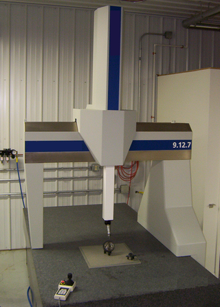
A coordinate measuring machine (CMM) is a device that measures the geometry of physical objects by sensing discrete points on the surface of the object with a probe. Various types of probes are used in CMMs, the most common being mechanical and laser sensors, though optical and white light sensor do exist. Depending on the machine, the probe position may be manually controlled by an operator or it may be computer controlled. CMMs typically specify a probe's position in terms of its displacement from a reference position in a three-dimensional Cartesian coordinate system. In addition to moving the probe along the X, Y, and Z axes, many machines also allow the probe angle to be controlled to allow measurement of surfaces that would otherwise be unreachable.

A level is an optical instrument used to establish or verify points in the same horizontal plane in a process known as levelling. It is used in conjunction with a levelling staff to establish the relative height or levels of objects or marks. It is widely used in surveying and construction to measure height differences and to transfer, measure, and set heights of known objects or marks.

A plumb bob, plumb bob level, or plummet, is a weight, usually with a pointed tip on the bottom, suspended from a string and used as a vertical direction as a reference line, or plumb-line. It is a precursor to the spirit level and used to establish a vertical datum. It is typically made of stone, wood, or lead, but can also be made of other metals. If it is used for decoration, it may be made of bone or ivory.
Continuous casting, also called strand casting, is the process whereby molten metal is solidified into a "semifinished" billet, bloom, or slab for subsequent rolling in the finishing mills. Prior to the introduction of continuous casting in the 1950s, steel was poured into stationary molds to form ingots. Since then, "continuous casting" has evolved to achieve improved yield, quality, productivity and cost efficiency. It allows lower-cost production of metal sections with better quality, due to the inherently lower costs of continuous, standardised production of a product, as well as providing increased control over the process through automation. This process is used most frequently to cast steel. Aluminium and copper are also continuously cast.

The rainbow or Benton hologram is a type of hologram invented in 1968 by Dr. Stephen A. Benton at Polaroid Corporation. Rainbow holograms are designed to be viewed under white light illumination, rather than laser light which was required before this. The rainbow holography recording process uses a horizontal slit to eliminate vertical parallax in the output image, greatly reducing spectral blur while preserving three-dimensionality for most observers. A viewer moving up or down in front of a rainbow hologram sees changing spectral colors rather than different vertical perspectives. Because perspective effects are reproduced along one axis only, the subject will appear variously stretched or squashed when the hologram is not viewed at an optimum distance; this distortion may go unnoticed when there is not much depth, but can be severe when the distance of the subject from the plane of the hologram is very substantial. Stereopsis and horizontal motion parallax, two relatively powerful cues to depth, are preserved.
The Australian Height Datum was introduced in 1971 as the official vertical datum for Australia, and thereby serves as the benchmark to which all height measurements are referred. The Australian Height Datum is an amalgamation of decades of spirit levelling work conducted by numerous state and territory authorities across the country, and was corrected to align with the mean sea level observations of thirty tide gauges positioned around the entire coastline. While it remains the published vertical datum for all surveying and engineering operations performed throughout Australia, newer technologies have uncovered numerous deficiencies, offsets and distortions within the Australian Height Datum, leading to discussions about defining a new Australian vertical datum.

A line array is a loudspeaker system that is made up of a number of usually identical loudspeaker elements mounted in a line and fed in phase, to create a near-line source of sound. The distance between adjacent drivers is close enough that they constructively interfere with each other to send sound waves farther than traditional horn-loaded loudspeakers, and with a more evenly distributed sound output pattern.
An optical dilatometer is a non-contact device able to measure thermal expansions or sintering kinetics of any kind of materials, unlike traditional push rod dilatometer, it can push up to the dilatometric softening of the specimen. It is a device for measuring changes in the dimensions of a specimen, optically, the achieved resolution can result in greater values than those of a conventional pushrod dilatometer. A monochromatic light source, such as a laser, illuminates the specimen. Some of the light is reflected by the specimen and interferes with the incoming light, creating optical interference fringes. As the specimen contracts or expands, there is a proportional movement of the interference fringes, which can be measured using a camera system. The measurement resolution is determined by the wavelength of the light, and is typically 0.5 μm for blue light. Optical dilatometers are used to measure thermal expansion.
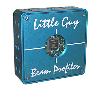
A laser beam profiler captures, displays, and records the spatial intensity profile of a laser beam at a particular plane transverse to the beam propagation path. Since there are many types of lasers — ultraviolet, visible, infrared, continuous wave, pulsed, high-power, low-power — there is an assortment of instrumentation for measuring laser beam profiles. No single laser beam profiler can handle every power level, pulse duration, repetition rate, wavelength, and beam size.

An architectural drawing or architect's drawing is a technical drawing of a building that falls within the definition of architecture. Architectural drawings are used by architects and others for a number of purposes: to develop a design idea into a coherent proposal, to communicate ideas and concepts, to convince clients of the merits of a design, to assist a building contractor to construct it based on design intent, as a record of the design and planned development, or to make a record of a building that already exists.
In astronomy, geography, and related sciences and contexts, a direction or plane passing by a given point is said to be vertical if it contains the local gravity direction at that point.
Tree height is the vertical distance between the base of the tree and the tip of the highest branch on the tree, and is difficult to measure accurately. It is not the same as the length of the trunk. If a tree is leaning, the trunk length may be greater than the height of the tree. The base of the tree is where the projection of the pith (center) of the tree intersects the existing supporting surface upon which the tree is growing or where the seed sprouted. If the tree is growing on the side of a cliff, the base of the tree is at the point where the pith would intersect the cliff side. Roots extending down from that point would not add to the height of the tree. On a slope this base point is considered as halfway between the ground level at the upper and lower sides of the tree. Tree height can be measured in a number of ways with varying degrees of accuracy.
This is a glossary of levelling terms. Levelling is a surveying method used to find relative height, one use of which is to ensure ground is level during construction, for example, when excavating to prepare for laying a foundation for a house.
