
Sussex County is the northernmost county in the U.S. state of New Jersey. Its county seat is Newton. It is part of the New York metropolitan area and is part of New Jersey's Skylands Region. As of the 2020 census, the county was the state's 17th-most-populous county, with a population of 144,221, a decrease of 5,044 (−3.4%) from the 2010 census count of 149,265, which in turn reflected an increase of 5,099 (+3.5%) over the 144,166 persons at the 2000 census. Based on 2020 census data, Vernon Township was the county's largest in both population and area, with a population of 22,358 and covering an area of 70.59 square miles (182.8 km2). The county is part of the North Jersey region of the state.

Route 70 is a state highway located in the U.S. state of New Jersey. It extends 59.8 mi (96.24 km) from an interchange with Route 38 in Pennsauken, Camden County, east to an intersection with Route 34 and Route 35 in Wall Township, Monmouth County. Route 70 cuts across the middle of the state as a two-lane highway through the Pine Barrens in Burlington and Ocean counties. A popular truck route, it provides access between Philadelphia and the surrounding Philadelphia metro area and the Jersey Shore resorts, particularly Long Beach Island by way of Route 72. It is also a congested commercial route within Philadelphia's New Jersey suburbs. The western section in Cherry Hill and Marlton is a four- to eight-lane divided highway that serves as a major suburban arterial and is locally known as Marlton Pike. The eastern section in Monmouth and Ocean counties is also a multilane divided highway that runs through suburban areas.
Wall Township is a township within Monmouth County, in the U.S. state of New Jersey. Crisscrossed by several different highways within the heart of the Jersey Shore region, the township is a transportation hub of Central New Jersey and a bedroom suburb of New York City, in the New York Metropolitan Area. As of the 2020 United States census, Wall Township's population was 26,525, its highest decennial count ever and an increase of 361 (+1.4%) from the 2010 census count of 26,164, which in turn reflected an increase of 903 (+3.6%) from the 25,261 counted in the 2000 census.

Brick Township is a township situated on the Jersey Shore within Ocean County, in the U.S. state of New Jersey. As of the 2020 United States census, the city retained its position as the state's 13th-most-populous municipality, with a population of 73,620, a decrease of 1,452 (−1.9%) from the 2010 census count of 75,072, which in turn reflected a decline of 1,047 residents (−1.4%) from its population of 76,119 at the 2000 census, when it was the state's 12th most-populous municipality.

Neshanic is an unincorporated community and census-designated place (CDP) located within Hillsborough Township, in Somerset County, in the U.S. state of New Jersey. It is located near the South Branch Raritan River. The Neshanic Historic District was listed on the National Register of Historic Places in 1979.

New Vernon is an unincorporated community and census-designated place (CDP) in Harding Township, Morris County, New Jersey, United States. New Vernon is the location of the governmental offices for Harding Township. As of the 2020 census, the population of New Vernon was 825.

Edwardsburgh/Cardinal is a township in the United Counties of Leeds and Grenville of eastern Ontario, Canada. Edwardsburgh township was first surveyed in 1783, and incorporated in 1850. The township was part of the historical Grenville County before it merged with Leeds County to form the United Counties in the 19th century.
Whiting is an unincorporated community located on the west side of Manchester Township in Ocean County, New Jersey, United States. It is in the Eastern Standard time zone with an elevation of 180 ft. It is home to various retirement communities. The ZIP Code Tabulation Area for the Whiting 08759 ZIP code has a population of 33,180 as of the 2019 Population Estimates Program from the United States Census Bureau. The majority of the township's population of 43,070 lives here.

Pine Brook, sometimes spelled Pinebrook, is a census-designated place (CDP) and unincorporated community in Montville Township, Morris County, New Jersey, United States. As of the 2020 United States census, the CDP had a population of 5,675.
Dutch Neck is an unincorporated community located within West Windsor Township in Mercer County, in the U.S. state of New Jersey. The community is centered about the intersection of Village Road East, Village Road West, and South Mill Road and has in the vicinity several churches, the West Windsor Volunteer Fire Company No. 1, Dutch Neck Elementary School, and many residences.
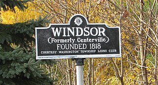
Windsor is a small historic unincorporated community and census-designated place (CDP) located within Robbinsville Township in Mercer County, in the U.S. state of New Jersey. The area is served as United States Postal Service ZIP Code 08561. As of the 2020 United States census, the CDP's population was 330, an increase of 104 (+46.0%) above the 226 counted at the 2010 census. The community, covering 570 acres (230 ha), was added to the National Register of Historic Places in 1992.

Pottersville is an unincorporated community and census-designated place (CDP) split between Bedminster Township in Somerset County and Tewksbury Township in Hunterdon County, in the U.S. state of New Jersey. The area is served as United States Postal Service ZIP Code 07979. As of the 2010 United States Census, the population for ZIP Code Tabulation Area 07979 was 589. In 1990, most of the village was listed on the National Register of Historic Places as the Pottersville Village Historic District.

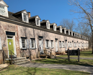
Batsto Village is a historic unincorporated community located on CR 542 within Washington Township in Burlington County, New Jersey, United States. It is located in Wharton State Forest in the south central Pine Barrens, and a part of the Pinelands National Reserve. It is listed on the New Jersey and National Register of Historic Places, and is administered by the New Jersey Department of Environmental Protection's Division of Parks & Forestry. The name is derived from the Swedish bastu, bathing place ; the first bathers were probably the Lenni Lenape Native Americans.

Rancocas is an unincorporated community located within Westampton Township in Burlington County, New Jersey. The name derives from the Native American word Rankokous, which was used in the name of the Powhatan Lenape Nation Indian Reservation located in Westampton Township. The name was also known as a sub-tribe of the Ancocus. The Reservation was a popular tourist destination for visitors from the Philadelphia area, New York, and local residents, before the Reservation became Rancocas State Park.
Bradevelt is an unincorporated community located within the Morganville section of Marlboro Township, in Monmouth County, in the U.S. state of New Jersey. County Route 520 travels through Bradevelt, while Route 79 is located west of the community. The area consists of a mix of businesses along the two main roads, farmland, and the remains of the Marlboro Psychiatric Hospital which is being converted to Big Brook Park. The former Monmouth County Agricultural Railroad runs north and south through Bradevelt. Early to mid 1800s the area was called Hulsetown.

Green Park, an unincorporated village located in northeastern Tyrone Township, Perry County, Pennsylvania, United States, sits at the intersection of state routes 233 and 274. The name was given to a local land tract by James Baxter in the late 1700s and made popular as an unofficial moniker for mid- to late-1800s picnic and camp meeting grounds located at the upper end of Stambaugh Farm Run. The town serves as Perry County's midpoint between the Conococheague Mountain in the west and the Susquehanna River to the east.

Atsion is an unincorporated community located within Shamong Township in Burlington County, in the U.S. state of New Jersey. The community is located next to Atsion Lake.

Finesville is an unincorporated community and census-designated place (CDP) located within Pohatcong Township in Warren County, in the U.S. state of New Jersey. The CDP was defined as part of the 2010 United States Census. As of the 2010 Census, the CDP's population was 175.

Millbrook, also known as Millbrook Village, is an unincorporated community located along Old Mine Road within Hardwick Township, formerly Pahaquarry Township, in Warren County, in the U.S. state of New Jersey. It is named after the Mill Brook, now known as Van Campens Mill Brook, a tributary of the Delaware River. The area is now part of the Delaware Water Gap National Recreation Area.


