Orange County is a county located in Central Florida, and as of the 2020 census, its population was 1,429,908 making it Florida's fifth-most populous county. Its county seat is Orlando, the core of the Orlando metropolitan area, which had a population of 2.67 million in 2020.

Taupō, sometimes written Taupo, is a town located in the central North Island of New Zealand. It is situated on the edge of Lake Taupō, which is the largest freshwater lake in New Zealand. Taupō was constituted as a borough in 1953. It has been the seat of Taupō District Council since the council was formed in 1989.

Pender Island is one of the Southern Gulf Islands located in the Gulf of Georgia, British Columbia, Canada. Pender Island is approximately 34 km2 (13 sq mi) in area and is home to about 2,250 permanent residents, as well as a large seasonal population. Like most of the rest of the Southern Gulf Islands, Pender Island enjoys a sub-Mediterranean climate and features open farmland, rolling forested hills, several lakes and small mountains, as well as many coves and beaches.
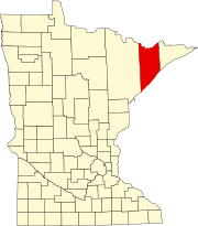
Minnesota State Highway 61 is a 148.843-mile-long (239.540 km) highway in northeast Minnesota, which runs from a junction with Interstate 35 (I-35) in Duluth at 26th Avenue East, and continues northeast to its northern terminus at the Canadian border near Grand Portage, connecting to Ontario Highway 61 at the Pigeon River Bridge. The route is a scenic highway, following the North Shore of Lake Superior, and is part of the Lake Superior Circle Tour designation that runs through Minnesota, Ontario, Michigan, and Wisconsin.

Forum Communications Company is an American multimedia and technology company headquartered in Fargo, North Dakota. With multiple online and print news brands throughout Minnesota, North Dakota, South Dakota and Wisconsin, Forum Communications offers local news in a variety of digital and broadcast mediums in addition to various niche media brands covering specialty interests.
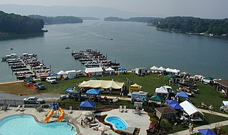
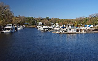
Smith Mountain Lake is a large reservoir in the Roanoke Region of Virginia, United States, located southeast of the City of Roanoke and southwest of Lynchburg. The lake was created in 1963 by the Smith Mountain Dam impounding the Roanoke River. The majority of the south shore of the lake lies in Franklin County while a small portion, including access to the dam, lies in Pittsylvania County. Bedford County makes up the northern half of the lake with the Roanoke River as the dividing line. The lake has become a popular recreation spot and has also experienced significant development in the last decade. It is the largest lake contained entirely within the Commonwealth of Virginia.


The North Shore of Lake Superior runs from Duluth, Minnesota, United States, at the western end of the lake, to Thunder Bay and Nipigon, Ontario, Canada, in the north, to Sault Ste. Marie, Ontario in the east. The shore is characterized by alternating rocky cliffs and cobblestone beaches, with forested hills and ridges through which scenic rivers and waterfalls descend as they flow to Lake Superior.

Tettegouche State Park is a Minnesota state park on the north shore of Lake Superior 58 miles (93 km) northeast of Duluth in Lake County on scenic Minnesota Highway 61. The park's name stems from the Tettegouche Club, an association of local businessmen which purchased the park in 1910 from the Alger-Smith Lumber Company. The club's members protected the area until its sale in 1971 to the deLaittres family. In 1979, the state of Minnesota acquired 3,400 acres (1,400 ha) from the Nature Conservancy, including Tettegouche Camp. The land was added to Baptism River State Park, which was renamed Tettegouche State Park.
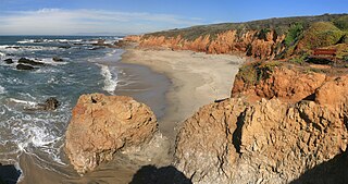
Pescadero State Beach is alongside State Route 1, located 14.5 miles south of Half Moon Bay and 1.5 miles west of the city of Pescadero in San Mateo County, California. The beach has a mile-long shoreline with sandy coves, rocky cliffs, tide pools, fishing spots and picnic facilities.

Lake Milton is a census-designated place in central Milton Township, Mahoning County, Ohio, United States. The population was 637 at the 2020 census. Located in northwestern Mahoning County, it sits along the shore of the Lake Milton reservoir, along with the village of Craig Beach. It is part of the Youngstown–Warren metropolitan area.

Finland is an unincorporated community and census-designated place (CDP) in Crystal Bay and Beaver Bay townships, Lake County, Minnesota, United States. As of the 2020 census, its population was 195.
Illgen City is an unincorporated community in Beaver Bay Township, Lake County, Minnesota, United States.
West Boca Raton, also known as West Boca, is an unincorporated community west of the city of Boca Raton, Florida. It is populated by numerous developments such as Boca Landings, The Hamptons, Mission Bay, Sandalfoot Cove, Century Village, and Loggers' Run.
The Koi Nation of the Lower Lake Rancheria is a federally recognized tribe of Southeastern Pomo people in northern California. Their name for their tribe is Koi Nation of Northern California, from their traditional village, Koi, once located on an island in Clear Lake.

The Interurban Trail is a rail trail in Whatcom County, Washington. Built for bicycle and hiking recreation, the trail runs 6.6 miles (10.6 km) between Fairhaven and Larrabee State Park in the Bellingham area.

Winchell Trail is a five-mile (8 km) round trip, pedestrian-only trail in Minneapolis, Minnesota, United States, that runs along the west side of the Mississippi River between Franklin Avenue South and East 44th Street. Popular with bird watchers and naturalists, the rustic trail provides Upper Mississippi River gorge access and views. The trail is separate from the adjacent multi-use bicycle path, taking hikers past sandy beaches, an oak savanna restoration project, and the floodplain forest. The trail has multiple access points and the section from East 38th Street to East 44th Street is paved. Described as moderate and for all hiking skill levels, the out-and-back Winchell Trail has total elevation gain of 501 feet (153 m). Portions of the trail can be hiked in near solitude as its age and general destitute make it a widely forgotten place to explore.

Little Earth Trail is an approximately 1-mile (1.6 km), multi-use bicycle path in Minneapolis, Minnesota, United States, that links several neighborhoods, parks, businesses, and trails in the Phillips community. The trail begins at its northern end near the intersection of East Franklin Avenue and 16th Avenue South and eventually follows the west side of Hiawatha Avenue to the Midtown Greenway and Martin Olav Sabo Bridge. Named after the nearby Little Earth community, the shared-use pathway provides transportation and recreation opportunities, and is a frequent location of activism on social justice issues in Minneapolis.
Watergate Marina is located on the north bank of the Mississippi River in Saint Paul, Minnesota, United States, upriver from the city's downtown area. Owned by the City of Saint Paul and operated via lease, the privately run, full-service marina has capacity for 160 ships and it charges fees for boat launches.