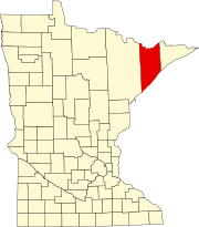
Two Harbors is a city in and the county seat of Lake County, Minnesota, United States, along the shore of Lake Superior. The population was 3,745 at the 2010 census

Muscogee, is a ghost town located twenty miles northwest of Pensacola, Florida, United States, in Escambia County, along the Perdido River. Named after the Muscogee Lumber Company, formed by Georgia lumber men, the European-American town was founded in 1857 by a group of lumbermen to harvest timber from the surrounding pine forests. They and the following company clearcut the timber, and once the forests were gone, lumbering ended in this area.

Split Rock Lighthouse State Park is a state park of Minnesota on the North Shore of Lake Superior. It is best known for the picturesque Split Rock Lighthouse, one of the most photographed lighthouses in the United States. Built by the United States Lighthouse Service in 1910, the lighthouse and some adjacent buildings have been restored and the Minnesota Historical Society operates them as a museum. The 2,200-acre (890 ha) state park offers a unique cart-in campground and scenic trails for hiking, cross-country skiing, and bicycling.

The Roaring Camp & Big Trees Narrow Gauge Railroad is a 3 ft narrow-gauge tourist railroad in California that starts from the Roaring Camp depot in Felton, California and runs up steep grades through redwood forests to the top of nearby Bear Mountain, a distance of 3.25 miles (5.23 km).

The North Shore of Lake Superior runs from Duluth, Minnesota, United States, at the southwestern end of the lake, to Thunder Bay and Nipigon, Ontario, Canada, in the north to Sault Ste. Marie, Ontario, in the east. The shore is characterized by alternating rocky cliffs and cobblestone beaches, with forested hills and ridges through which scenic rivers and waterfalls descend as they flow to Lake Superior.

The St. Croix Boom Site is a historic and scenic wayside on the St. Croix River in Stillwater Township, Minnesota, United States. It commemorates the location of a critical log boom where, from 1856 to 1914, timber from upriver was sorted and stored before being dispatched to sawmills downstream. The site was developed as a roadside park along Minnesota State Highway 95 in the 1930s. In 1966 it was designated a National Historic Landmark for its national significance in the theme of industry. It was nominated for being the earliest, most important, and longest serving of the log storage and handling operations that supported Minnesota's major logging industry. Virtually no traces remain of the site's original buildings and structures.

The Laurel Fork Railway was a small, standard-gauge logging railroad that operated entirely in Carter County, Tennessee from 1912 to 1927. Built by the Pittsburgh Lumber Company to serve a double-band sawmill at Braemar, in present-day Hampton, Tennessee.

The California, Shasta and Eastern Railway was a 15 miles (24 km) shortline railroad which operated, for nearly 40 years, between Anderson and Bella Vista, California with no greater aspirations then being a glorified mill spur. Briefly around 1906 however, the road basked in the limelight of the mighty E.H. Harriman who considered, and then discarded, the idea of incorporating it into one of his "paper" railroads projected through the region.

Pino Grande is an unincorporated community in El Dorado County, California. It is located 8 miles (13 km) north-northwest of Pollock Pines, at an elevation of 4022 feet.
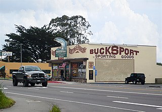
Bucksport was a town in Humboldt County, California. The original location was 2.5 miles (4 km) southwest of downtown Eureka, on Humboldt Bay about 5 miles (8 km) northeast of entrance. at an elevation of 16 feet (4.9 m). Prior to American settlement a Wiyot village named Kucuwalik stood here.

Andersonia is an unincorporated community in Mendocino County, California. It is located near U.S. Route 101 on the South Fork of the Eel River 1 mile (1.6 km) north-northwest of Piercy, at an elevation of 541 feet.

The Split Rock River is a 3.5-mile-long (5.6 km) river of Minnesota, in the United States. It drains a small watershed of about 40 square miles (100 km2) on the North Shore of Lake Superior. The name was used as early as 1825 and is believed to refer either to the steep-walled gorge carved by the river or to two cliffs east of the river mouth that appear split apart. An indigenous name for the river was Gininwabiho-zibi, meaning "War Eagle Iron River." The river's lower course flows through Split Rock Lighthouse State Park, and the Superior Hiking Trail ascends and descends both banks. There is a separate stream called Split Rock Creek nearby.

Robinette is a former unincorporated community in Baker County, Oregon, United States.
The Caspar, South Fork & Eastern Railroad provided transportation for the Caspar Lumber Company in Mendocino County, California. The railroad operated the first steam locomotive on the coast of Mendocino County in 1875. Caspar Lumber Company lands became Jackson Demonstration State Forest in 1955, named for Caspar Lumber Company founder, Jacob Green Jackson.

Gooseberry River is a 23-mile stream in Lake County, Minnesota, USA, draining into Lake Superior. It is known for its waterfalls, near its mouth in Gooseberry Falls State Park. The Gooseberry, like many of its neighboring streams, has an irregular discharge highly dependent on runoff from rain and snow melt. The region around the river was heavily forested and much logging took place during the early 20th century. The forest has since regrown and the falls and mouth of the river are now a thriving tourist destination.
Fernwood Lumber Company had its beginning in the 1870s when John Fletcher Enochs and his son, Isaac Columbus Enochs, started a lumber business near Crystal Springs in Copiah County, Mississippi. Between 1880 and 1920, Fernwood Lumber Company became one of the largest lumber operations in south Mississippi with investments in timberland, lumber mills, and railroads.
Black Rock is an unincorporated community and former logging camp in Polk County, Oregon, United States. It is located about three miles west of Falls City, in the Central Oregon Coast Range on the Little Luckiamute River.
Mendocino Lumber Company operated a sawmill on Big River near the town of Mendocino, California. The sawmill began operation in 1853 as the Redwood Lumber Manufacturing Company, and changed ownership several times before cutting its final logs in 1938. The sawmill site became part of the Big River Unit of Mendocino Headlands State Park where a few features of the mill and its associated forest railway are still visible along the longest undeveloped estuary in northern California.

The Missouri Lumber and Mining Company (MLM) was a large timber corporation with headquarters and primary operations in southeast Missouri. The company was formed by Pennsylvania lumbermen who were eager to exploit the untapped timber resources of the Missouri Ozarks to supply lumber, primarily used in construction, to meet the demand of U.S. westward expansion. Its primary operations were centered in Grandin, a company town it built starting c. 1888. The lumber mill there grew to be the largest in the country at the turn of the century and Grandin's population peaked around 2,500 to 3,000. As the timber resources were exhaused, the company had to abandon Grandin around 1910. It continued timber harvesting in other parts of Missouri for another decade. While some of the buildings in Grandin were relocated, many of the remaining buildings were listed on the National Register of Historic Places in 1980 as part of the state's historic preservation plan which considered the MLM a significant technological and economic contributor to Missouri.