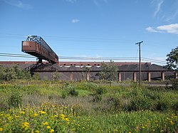
The city of Silver Bay was founded on May 1, 1954, after previously being known as the Beaver Bay housing project. The company town was built to process taconite mined and shipped by train from Babbitt, Minnesota, sixty miles to the northwest.[7]
Silver Bay attained widespread publicity in the 1960s when it was discovered that the Reserve Corporation was dumping taconite tailings into Lake Superior. In 1972 they were forced to stop and charged with violating the Rivers and Harbors Act of 1899, which prohibited the dumping of harmful materials into interstate waters. In 1977, after a long trial, a new waste-storage facility was built 7 miles inland. Often referred to as “Mile Post 7”
Black Beach, named for the darkly-colored taconite tailings in its sand, is now a popular tourist attraction
In 2015, the taconite tailing-rich Black Beach opened to the public,[9] the negotiation with the mining company for public access to the beaches in the area being brokered by the city of Silver Bay and the state DNR. Black Beach Park contains three beaches and a municipally owned campground.[10]
Geography
According to the United States Census Bureau, the city has a total area of 8.36 square miles (21.65km2), of which 7.89 square miles (20.44km2) is land and 0.47 square miles (1.22km2) is water.[11]
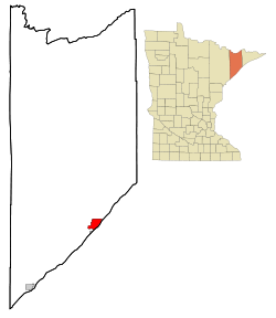
Silver Bay is located 28 miles northeast of Two Harbors, 54 miles northeast of Duluth, 55 miles southwest of Grand Marais, and about 100 miles south of the Canadian border. It is about halfway between Duluth and Grand Marais, along the North Shore of Lake Superior.
Summer hiking trails, winter cross country skiing, maintained snowmobile trails , multiple parks, a hockey arena, and 4 baseball/softball fields are located within Silver Bay.
As of the census of 2010, there were 1,887 people, 836 households, and 542 families living in the city. The population density was 239.2 inhabitants per square mile (92.4/km2). There were 974 housing units at an average density of 123.4 per square mile (47.6/km2). The racial makeup of the city was 97.9% White, 0.2% African American, 0.3% Native American, 0.3% Asian, 0.3% from other races, and 1.0% from two or more races. Hispanic or Latino of any race were 0.9% of the population.
There were 836 households, of which 22.8% had children under the age of 18 living with them, 53.3% were married couples living together, 6.7% had a female householder with no husband present, 4.8% had a male householder with no wife present, and 35.2% were non-families. 31.7% of all households were made up of individuals, and 15.9% had someone living alone who was 65 years of age or older. The average household size was 2.17 and the average family size was 2.69.
The median age in the city was 50.1 years. 18.4% of residents were under the age of 18; 6.9% were between the ages of 18 and 24; 17.4% were from 25 to 44; 28.6% were from 45 to 64; and 28.8% were 65 years of age or older. The gender makeup of the city was 51.8% male and 48.2% female.
2000 census
As of the census of 2000, there were 2,068 people, 844 households, and 589 families living in the city. The population density was 268.0 inhabitants per square mile (103.5/km2). There were 933 housing units at an average density of 120.9 per square mile (46.7/km2). The racial makeup of the city was 97.68% White, 0.05% African American, 1.11% Native American, 0.15% Asian, 0.05% Pacific Islander, 0.10% from other races, and 0.87% from two or more races. Hispanic or Latino of any race were 0.68% of the population. Germans comprised 22.2% of the population, 18.1% Norwegian, 11.5% Swedish, 6.5% Finnish, 6.4% American, 6.1% Irish, and 5.2% English ancestry.
There were 844 households, out of which 28.2% had children under the age of 18 living with them, 59.8% were married couples living together, 7.1% had a female householder with no husband present, and 30.1% were non-families. Individuals comprised 27.6% of all households, and 14.3% had someone living alone who was 65 years of age or older. The average household size was 2.35 and the average family size was 2.85.
In the city, the population was spread out, with 24.4% under the age of 18, 4.3% from 18 to 24, 23.4% from 25 to 44, 20.8% from 45 to 64, and 27.2% who were 65 years of age or older. The median age was 44 years. For every 100 females, there were 104.8 males. For every 100 females age 18 and over, there were 105.8 males.
The median income for a household in the city was $36,524, and the median income for a family was $41,667. Males had a median income of $40,655 versus $25,809 for females. The per capita income for the city was $16,958. About 5.3% of families and 6.8% of the population were below the poverty line, including 8.5% of those under age 18 and 2.9% of those age 65 or over.
Infrastructure
Transportation
Silver Bay was served by the Silver Bay Municipal Airport until it closed on June 7, 2018, for an indefinite amount of time.[13]
Outer Drive (County Road 5), Penn Boulevard, and Minnesota Highway 61 are three of the main routes in Silver Bay.
↑"Minnesota's unnaturally beautiful Black Beach". Exploration Vacation. June 11, 2023. Retrieved April 25, 2024. Black Beach officially opened to the public in 2015 and grows in popularity every year. It's not a local secret anymore – these days it is very, very busy on summer weekends.
↑"Black Beach Campground and Recreational Park Information"(PDF). City of Black Beach. p.11. Retrieved April 25, 2024. The City of Silver Bay and the MN DNR, entered into a Lease Agreement with Northshore Mining for 31.6 acres (approximately 3500 feet of shoreline) of property along Lake Superior's North Shore for the purpose of public beaches. The agreement was fully executed in November 2014. • Black Beach is known for the natural sediment transport of past taconite tailings into sand that gives a diamond like sparkle with black hue.
This page is based on this Wikipedia article Text is available under the CC BY-SA 4.0 license; additional terms may apply. Images, videos and audio are available under their respective licenses.