
Douglas County is a county located in the U.S. state of Colorado. As of the 2020 Census, the population was 357,978. The county is named in honor of U.S. Senator Stephen A. Douglas. The county seat is Castle Rock.

Adams County is a county located in the U.S. state of Colorado. As of the 2020 census, the population was 519,572. The county seat is Brighton, and the largest city is Thornton. The county is named for Alva Adams, an early Governor of the State of Colorado in 1887–1889. Adams County is part of the Denver–Aurora–Lakewood, CO Metropolitan Statistical Area.
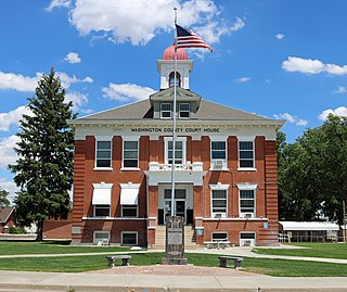
Washington County is a county located in the eastern side of the U.S. state of Colorado. As of the 2020 census, the population was 4,817. The county seat is Akron. The county was named in honor of the United States President George Washington.

Jefferson County is a county located in the U.S. state of Colorado. As of the 2020 census, the population was 582,910, making it the fourth-most populous county in Colorado. The county seat is Golden, and the most populous city's Lakewood.

Arapahoe County is a county located in the U.S. state of Colorado. As of the 2020 census, its population was 655,070, making it the third-most populous county in Colorado. The county seat is Littleton, and the most populous city is Aurora. The county was named for the Arapaho Native American tribe, who once lived in the region.
Bennett is a Statutory Town located in Adams and Arapahoe counties, Colorado, United States. The town population was 2,862 at the 2020 United States Census with 2,443 residing in Adams County and 419 residing in Arapahoe County.

The City of Commerce City is a home rule municipality located in Adams County, Colorado, United States. The city population was 62,418 at the 2020 United States Census, a 35.95% increase since the 2010 United States Census. Commerce City is the 18th most populous municipality in Colorado. Commerce City is located north of Denver and is a part of the Denver–Aurora–Lakewood, CO Metropolitan Statistical Area and the Front Range Urban Corridor. Commerce City is a mixed residential and industrial community that is known for an oil refinery with a capacity of 90,000 barrels per day (14,000 m3/d), operated by Suncor. Dick's Sporting Goods Park, a soccer stadium in Commerce City, hosts the Colorado Rapids of Major League Soccer.
The City of Cherry Hills Village is a home rule municipality located in Arapahoe County, Colorado, United States. The city population was 6,442 at the 2020 United States Census. Cherry Hills Village is a part of the Denver–Aurora–Lakewood, CO Metropolitan Statistical Area and the Front Range Urban Corridor.
The City of Englewood is a home rule municipality located in Arapahoe County, Colorado, United States. The town population was 33,659 at the 2020 United States Census. Englewood is a part of the Denver–Aurora–Lakewood, CO Metropolitan Statistical Area and the Front Range Urban Corridor. Englewood is located immediately south of Denver in the South Platte River Valley.

The City of Glendale is a home rule municipality located in an exclave of Arapahoe County, Colorado, United States. The city population was 4,613 at the 2020 United States Census. Glendale is an enclave of the City and County of Denver and is the most densely populated municipality in Colorado. The city is a part of the Denver–Aurora–Lakewood, CO Metropolitan Statistical Area and the Front Range Urban Corridor.

Centennial is a home rule municipality located in Arapahoe County, Colorado, United States. The city population was 108,418 at the 2020 United States Census, making Centennial the 11th most populous municipality in Colorado. Centennial is a part of the Denver–Aurora–Lakewood, CO Metropolitan Statistical Area and the Front Range Urban Corridor.
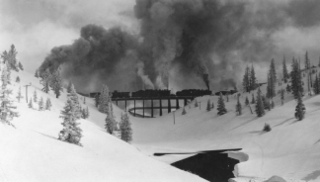
Rollins Pass, elevation 11,676 ft (3,559 m), is a mountain pass and active archaeological site in the Southern Rocky Mountains of north-central Colorado in the United States. The pass is located on and traverses the Continental Divide of the Americas at the crest of the Front Range southwest of Boulder and is located approximately five miles east and opposite the resort in Winter Park—in the general area between Winter Park and Rollinsville. Rollins Pass is at the boundaries of Boulder, Gilpin, and Grand counties. Over the past 10,000 years, the pass provided a route over the Continental Divide between the Atlantic Ocean watershed of South Boulder Creek with the Pacific Ocean watershed of the Fraser River, a tributary of the Colorado River.

Colorado's 6th congressional district is a congressional district in the U.S. state of Colorado. Located in central Colorado, the district encompasses much of the eastern part of the Denver metropolitan area, including all of Aurora, as well as portions of the southern and northern metro area.
South Arapahoe County was a county of the State of Colorado that existed for five months until it was renamed Arapahoe County in 1903.
Arapahoe County was a county of the extralegal United States Territory of Jefferson that existed from November 28, 1859, until February 28, 1861. The county name was also spelled Arapaho County, Arapahoe County, Arrapahoe County, and Arappahoe County. The county seat was Denver City.

This is a list of the National Register of Historic Places listings in Arapahoe County, Colorado.

The 2014 Colorado gubernatorial election was held on November 4, 2014, to elect the Governor and Lieutenant Governor of Colorado, concurrently with the election to Colorado's Class II U.S. Senate seat, as well as other elections to the United States Senate in other states and elections to the United States House of Representatives and various state and local elections.
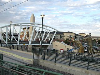
The following is a timeline of the history of the city of Aurora, Colorado, USA.


