Leonidas, New Orleans

Last updated
Leonidas
PinStripeBandOakPoBoy07Parading2.jpg
Second lining down Oak Street during the Po-Boy Festival
Nickname(s): 
Pigeon Town / Pension Town (a portion of it)
Coordinates: 29°57′21″N90°07′44″W / 29.95583°N 90.12889°W / 29.95583; -90.12889
CountryUnited States
StateLouisiana
City New Orleans
Planning DistrictDistrict 3, Uptown/Carrollton
Area
  Total1.05 sq mi (2.7 km2)
  Land0.92 sq mi (2.4 km2)
  Water0.13 sq mi (0.3 km2)
Elevation
0 ft (0 m)
Population
 (2010)
  Total3,288
  Density3,100/sq mi (1,200/km2)
Time zone UTC-6 (CST)
  Summer (DST) UTC-5 (CDT)
Area code 504

Leonidas (also known as West Carrollton) is a neighborhood designation in the city of New Orleans. A subdistrict of the Uptown/Carrollton Area, its boundaries as defined by the New Orleans City Planning Commission are: South Claiborne Avenue, Leonidas and Fig Streets to the north, South Carrollton Avenue to the east, the Mississippi River and Jefferson Parish to the west. Although an official city planning district name, the name "Leonidas" is not widely used nor has it any historical usage and the area is usually referred to by the larger neighborhood "Uptown, or "Carrollton".

Contents

The designated neighborhood incorporates the upper-river half of what had been the town of Carrollton, Louisiana, in the 19th century. It is commonly known to locals simply as "Carrollton, or to distinguish this section, "Upper Carrollton" or "West Carrollton".

The portion closer to the river is often called the "Riverbend" or "Carrollton Riverbend." The section closer to the Jefferson Parish line is sometimes known as "Pigeon Town/Pension Town".

Today the area thrives on its commercial businesses but it also includes a large residential community. Landmarks in the neighborhood include the Camellia Grill, the Carrollton Streetcar Barn, Palmer Park, the Water Works, and the Oak Street commercial district (including the well known Maple Leaf Bar). [1]

Name

The formal name for the neighborhood, Leonidas, may have been derived from the famous Spartan King of 490 B.C. However, as the name also is connected with the street that intersects the neighborhood, Leonidas Street, it is more likely to have derived from Leonidas Polk, Episcopalian "fighting bishop" for whom the street was possibly renamed following the end of Reconstruction. [2] [3]

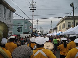
The informal name, Pigeon Town, has been passed down through generations. The name has its roots in the word, pidgin. [4] It is defined as a simplified speech used for communication between people with different languages. [5]

"Pigeon Town Food Market" Leonidas Street Cambarone Pegion Town Food Mart.JPG
"Pigeon Town Food Market" Leonidas Street

History

The Leonidas neighborhood area has history dating all the way back to the 1700s. Jean-Baptiste Le Moyne de Bienville, a French colonizer and the founder of the city of New Orleans, began a plantation in the area circa 1719. [6] The land went on to remain a plantation for different types of agriculture well into the 1800s. The area was then bought by the New Orleans Canal and Banking Company and was divided into sections. In 1835, the first house was built and soon emerged a new neighborhood of the city of New Orleans. [6] The Leonidas neighborhood was a part of a bigger whole called the town of Carrollton. In the 1850s, Dublin was the main street of the town. Fast forward almost a century and a half later in 1980, the town of Carrollton along with the Leonidas neighborhood was purchased and divided the city into 13 districts and 72 neighborhoods by the New Orleans City Planning Commission. [7]

Recent development

A part of the Uptown/Carrollton area that escaped serious Katrina-related damage, the Oak Street commercial corridor is staging a comeback from problems that had begun to accumulate well before 2005. Numerous changes in public perceptions, crimes and city services

“Six months of major street repair and utility construction created new pedestrian-friendly amenities along a half-mile of Oak Street…” [8] This project was to rebuild the roadways and make it a friendlier and safe way for people to walk to places. Leonidas is mainly a place for walking. Driving around, you could miss all the exciting and amazing events that go on. The project also includes the fixing of major water lines, drainpipes and sewer lines. As of today more and more people are driving places, this recreation promotes the using of non-motorized vehicles to make New Orleans an eco-friendlier environment.

Pigeon Town / Pension Town used to be known as an area of the bullets and the drugs and the fear. There were numerous killings and gunfire reported from the neighborhood. For instance, in the report by Walt Philbin, a man was shot to death with three people wounded in the incident close to the murder scene. The article also mentions numerous bullet casings that litter the surrounding areas in the neighborhood. Perhaps the greatest concern to each individual's life in New Orleans city are an increasing number of street crimes and break-in offenses. Project NOLA is an anti-crime nonprofit organization developed to help keep people in New Orleans area safe by providing public awareness of all dangerous situations happening within the community. The neighborhood of Leonidas in New Orleans is part of a major crime-fighting initiative thanks to several generous donations. The neighborhood has had dozens of HD crime cameras installed. [9]

Geography

Leonidas is located at 29°57′21″N90°07′44″W / 29.95583°N 90.12889°W / 29.95583; -90.12889 [10] and has an elevation of 0 feet (0.0 m). [11] According to the United States Census Bureau, the district has a total area of 1.05 square miles (2.7 km2). 0.92 square miles (2.4 km2) of which is land and 0.13 square miles (0.3 km2) (12.38%) of which is water.

Adjacent Neighborhoods

Boundaries

The New Orleans City Planning Commission defines the boundaries of Leonidas as these streets: South Claiborne Avenue, Leonidas Street, Fig Street, South Carrollton Avenue, the Mississippi River and Jefferson Parish. [1] A subdistrict of the Uptown/Carrollton Area, its boundaries as defined by the New Orleans City Planning Commission are: [1] South Claiborne Avenue, Leonidas and Fig Streets to the north, South Carrollton Avenue to the east, The Mississippi River and Jefferson Parish to the west. The designated neighborhood incorporates the upper-river half of what had been the town of Carrollton. The portion closer to the river is often called the "Riverbend." [1]

The section closer to the Jefferson Parish line is sometimes known as "Pigeon Town / Pension Town." [1]

Palmer Park

Center part of Palmer Park Palmer Park (Center).JPG
Center part of Palmer Park

There are several historical landmarks in Leonidas, many of which have been restored since the destruction due to Hurricane Katrina. One local landmark is Palmer Park, which is located at the corner of S. Carrollton Ave. and S. Claiborne Ave. It is a historical landmark, part of the Carrollton Historic District. The park provides space for concerts, home tours, festivals, and filming. The park is more children friendly after the construction of brand-new jungle gym, rock climbing wall, swings, and slides. Each month, usually on the last Saturday of the month, the park holds an event called the Palmer Park Art Market. It is a food, arts, and craft event that showcases local craftsmen, artisans, and provides local New Orleans food. [12]

Playground in Palmer Park New Playground.JPG
Playground in Palmer Park

Education

Leonidas is under the Orleans Parish School Board (OPSB).

Leonidas does not offer as many school choices as does other neighborhoods. There were formerly four main schools in Leonidas. One of the four, Audubon Charter School, has closed down and moved to another spot. The three schools currently located in Leonidas are St. Andrew’s Episcopal School, St. Joan of Arc Roman Catholic School, and James H. Bright / J. W. Johnson Elementary. Most of the schools around this neighborhood have closed for different reasons. Even now there are new schools and forms of education being rebuilt in Leonidas.

Politics

The Leonidas neighborhood is a part of District A in New Orleans. [16] This district consists of seven wards including the Leonidas neighborhood. [17]

The representative for this neighborhood on a city level is the Democrat Susan Guidry. [18] She was elected in 2010 and then re-elected for a second term in 2014 against her four competitors. [18] The issues that she focused on in her race include criminal justice committee chair, economic development and quality of life, and Maple Street bars and businesses. All these issues are important to the Leonidas neighborhood because crime and violence are a big issue in the Leonidas neighborhood. Guidry wants to make the neighborhood safer by eliminating the problem from the source and creating a stronger force to keep the problems from reoccurring. [18]

Its representative in the Louisiana House is Democrat Neil Abramson who was elected in 2007. [19] His term focuses on human trafficking and hurricane recovery. [19] The Louisiana Senate Representative is Republican Conrad Appel who has been in office since 2008. [19] His focus for his term consists of trade based economic development and development in higher education. [19]

The polling place for the Leonidas neighborhood is Audubon Charter which is located 719 S Carrollton Ave. On elections held on Tuesday, Audubon Charter is open from 6am to 8pm. When election are held on Saturday, it is open from 7am to 8pm. In order to vote registration and an ID with a signature is needed. Voters of the Leonidas neighborhood can register at the City Hall which is located at 1300 Perdido Street, Room #1W23 or 225 Morgan Street, Room #105. [20]

Demographics

Demographics chart Demographics chart.png
Demographics chart

The Leonidas neighborhood takes up about 1.054 square miles in the Uptown area of New Orleans. [21] According to the data center that population of the Leonidas neighborhood in 2000 was 8,953. This population decreased in 2010 to 6,769. The drastic population decreased because of Hurricane Katrina. [22]

The demographics of the neighborhood have changed over a ten-year span. Some of these aspects include occupancy and income. In the year of 2000 vacancy was 12% but after the census in 2010 it increased to 25.9%. [22] Income was also affected because of public assistance and average income. People who depended on public assistance income to pay their bills was 6.8% in 2000 and decreased to 0.1% in 2010. [22] This decrease probably occurred from the city having to more funds in rebuilding the city, therefore public assistance funds became scarcer. The average income of the citizens in the Leonidas neighborhood was $44,119 in 2000 and increased to $51,216 in 2010. [22]

Other aspects that were affected demographically over time include population in aspects of race and age. Over the ten-year span the population of whites increased 20.6% to 30.7%. [22] On the other hand, the population of blacks decreased from 75.5% to 62%. [22] Even though the population of blacks in the neighborhood is decreasing the percentages show that there are mostly blacks. The ages of the residents in this neighborhood stayed constant between the two censuses. The only drastic change consisted of the age range from 50-64 changed from 14.5% to 20.7%. [22]

As of the census of 2000, there were 8,953 people, 3,633 households, and 2,051 families residing in the neighborhood. [23] The population density was 9,731 /mi² (3,730 /km2).

As of the census of 2010, there were 6,769 people, 3,001 households, and 1,484 families residing in the neighborhood. [23]

See also

Related Research Articles

<span class="mw-page-title-main">Streetcars in New Orleans</span>

Streetcars in New Orleans have been an integral part of the city's public transportation network since the first half of the 19th century. The longest of New Orleans' streetcar lines, the St. Charles Avenue line, is the oldest continuously operating street railway system in the world. Today, the streetcars are operated by the New Orleans Regional Transit Authority (RTA).

<span class="mw-page-title-main">Carrollton, New Orleans</span> United States historic place

Carrollton is a historic neighborhood of Uptown New Orleans, Louisiana, USA, which includes the Carrollton Historic District, recognized by the Historic District Landmark Commission. It is the part of Uptown New Orleans farthest upriver while still being easily accessible to the French Quarter. It was historically a separate town, laid out in 1833 and incorporated on March 10, 1845. Carrollton was annexed by New Orleans in 1874, but it has long retained some elements of distinct identity.

<span class="mw-page-title-main">St. Charles Streetcar Line</span> Streetcar line in New Orleans, Louisiana

The St. Charles Streetcar Line is a historic streetcar line in New Orleans, Louisiana. Running since 1835, it is the oldest continuously operating streetcar line in the world. It is operated by the New Orleans Regional Transit Authority (RTA). Officially the St. Charles Streetcar line is designated as Route 12, and it runs along its namesake, St. Charles Avenue. It is the busiest route in the RTA system as it is heavily used by local commuters and tourists. On most RTA maps and publications, it is denoted in green, which is also the color of the streetcars on this line.

<span class="mw-page-title-main">Broadmoor, New Orleans</span> New Orleans Neighborhood in Louisiana, United States

Broadmoor is a neighborhood of the city of New Orleans. A subdistrict of the Uptown/Carrollton Area, its boundaries as defined by the New Orleans City Planning Commission are: Eve Street to the north, Washington Avenue and Toledano Street to the east, South Claiborne Avenue to the south, and Jefferson Avenue, South Rocheblave Street, Nashville Avenue, and Octavia Street to the west. It includes the Broadmoor Historic District which was listed on the National Register of Historic Places in 2003 and increased in its boundaries in 2007.

<span class="mw-page-title-main">Uptown New Orleans</span> United States historic place

Uptown is a section of New Orleans, Louisiana, United States, on the east bank of the Mississippi River, encompassing a number of neighborhoods between the French Quarter and the Jefferson Parish line. It remains an area of mixed residential and small commercial properties, with a wealth of 19th-century architecture. It includes part or all of Uptown New Orleans Historic District, which is listed on the National Register of Historic Places.

<span class="mw-page-title-main">Central City, New Orleans</span> Neighborhood in New Orleans, Louisiana, United States

Central City is a neighborhood of the city of New Orleans. It is located in the 11th Ward of New Orleans in Uptown, just above the Garden District, on the "lakeside" of St. Charles Avenue. A subdistrict of the Central City/Garden District Area, its boundaries as defined by the City Planning Commission are: MLK Boulevard, South Claiborne Avenue and the Pontchartrain Expressway to the north, Magazine, Thalia, Prytania and Felicity Streets and St. Charles Avenue to the south and Toledano Street, Louisiana Avenue and Washington Avenue to the west. This old predominantly African-American neighborhood has been important in the city's brass band and Mardi Gras Indian traditions.

<span class="mw-page-title-main">17th Ward of New Orleans</span>

The 17th Ward is one of the 17 Wards of New Orleans, a section of the city of New Orleans, Louisiana. New Orleans Districts and Wards. The 17th Ward, along with the 16th, was formed when the City of New Orleans annexed City of Carrollton in 1870.

<span class="mw-page-title-main">16th Ward of New Orleans</span>

The 16th Ward or Sixteenth Ward is a division of the city of New Orleans, Louisiana, one of the 17 Wards of New Orleans. It is an Uptown ward, along with the adjacent 17th Ward, formerly part of the city of Carrollton, Louisiana which was annexed by New Orleans in the 1870s.

<span class="mw-page-title-main">14th Ward of New Orleans</span>

The 14th Ward or Fourteenth Ward is a section of the city of New Orleans, Louisiana, one of the 17 Wards of New Orleans. The Ward was formed in 1870 from part of Jefferson City and the town of Greenville, which were annexed by New Orleans.

The city planning commission for New Orleans divided the city into 13 planning districts and 73 distinct neighborhoods in 1980. Although initially in the study 68 neighborhoods were designated, and later increased by the City Planning Commission to 76 in October 2001 based in census data, most planners, neighborhood associations, researchers, and journalists have since widely adopted the 73 as the number and can even trace the number back to the early 1900s. While most of these assigned boundaries match with traditional local designations, some others differ from common traditional use. This is a result of the city planning commission's wish to divide the city into sections for governmental planning and zoning purposes without crossing United States census tract boundaries. While most of the listed names have been in common use by New Orleanians for generations, some designated names are rarely heard outside the planning commission's usage.

<span class="mw-page-title-main">Sauvé's Crevasse</span>

Sauvé's Crevasse was a Mississippi River levee failure in May 1849 that resulted in flooding much of New Orleans, Louisiana.

<span class="mw-page-title-main">East Carrollton, New Orleans</span> Neighborhood in New Orleans, Louisiana, US

East Carrollton is a neighborhood of the city of New Orleans. A subdistrict of the Uptown/Carrollton Area, its boundaries as defined by the New Orleans City Planning Commission are: Spruce Street to the northeast, Lowerline Street to the southeast, St. Charles Avenue to the southwest and South Carrollton Avenue to the northwest.

<span class="mw-page-title-main">Audubon, New Orleans</span> New Orleans Neighborhood in Louisiana, United States

Audubon is a neighborhood of the city of New Orleans. A subdistrict of the Uptown/Carrollton Area, its boundaries as defined by the New Orleans City Planning Commission are: South Claiborne Avenue to the north, Jefferson Avenue to the east, the Mississippi River and Magazine Street to the south, and Lowerline Street to the west. The name Audubon comes from Audubon Park, one of the largest parks in the city, which is located in the southern portion of the district. The area is also known as the "University District," as it is also home of Tulane and Loyola Universities, as well as the former St. Mary’s Dominican College, and Newcomb College. The Audubon neighborhood was also the home of the original campus of Leland University. The section of the neighborhood upriver from Audubon Park incorporates what was the town of Greenville, Louisiana until it was annexed to New Orleans in the 19th century; locals still sometimes call that area "Greenville".

<span class="mw-page-title-main">Hollygrove, New Orleans</span> New Orleans Neighborhood in Louisiana, United States

Hollygrove is a neighborhood of the city of New Orleans, Louisiana, located in the city's 17th Ward. A subdistrict of the Uptown/Carrollton area, the boundaries as defined by the New Orleans City Planning Commission are the following: Palmetto Street to the north, Cambronne, Edinburgh, Forshey, Fig and Leonidas Streets to the east, Earhart Boulevard to the south and the Jefferson Parish boundary to the west. Conrad playground, the Cuccia-Byrnes playground and Larry Gilbert baseball stadium are located in Hollygrove. The Hollygrove Market and Farm is also located in Hollygrove. Notable people including rapper Lil Wayne have grown up in the neighborhood.

<span class="mw-page-title-main">Gert Town, New Orleans</span> Neighborhood in New Orleans, Louisiana, United States

Gert Town is a neighborhood in the city of New Orleans, Louisiana. It is the home to Xavier University of Louisiana and is near Mid-City. Gert Town played a major role in the industrial development of the New Orleans region. The Blue Plate Mayonnaise Factory, Coca-Cola Bottling Plant, Sealtest Dairy, and Thompson-Hayward Chemical Company were all fundamental manufacturing bases of the working-class neighborhood. Gert Town was also well known for being a center of development for jazz and other music genres. Musicians such as Buddy Bolden, John Robichaux, Merry Clayton, Bunk Johnson and Allen Toussaint all came from the neighborhood and helped shape the musical influence of New Orleans.

Magazine Street is a major thoroughfare in New Orleans, Louisiana. Like Tchoupitoulas Street, St. Charles Avenue, and Claiborne Avenue, it follows the curving course of the Mississippi River. The street took its name from an ammunition magazine located in this vicinity during the 18th-century colonial period.

<span class="mw-page-title-main">Freret, New Orleans</span> New Orleans neighborhood in Louisiana, United States

Freret is a neighborhood of the city of New Orleans, Louisiana. The Freret neighborhood contains a thriving commercial corridor. A subdistrict of the Uptown/Carrollton Area, its boundaries as defined by the New Orleans City Planning Commission are: South Claiborne Avenue to the north, Napoleon Avenue to the east, LaSalle Street to the south and Jefferson Avenue to the west. The name of the neighborhood stems from Freret Street, which was named for William Freret, a mid-19th-century New Orleans mayor.

<span class="mw-page-title-main">Fontainebleau, New Orleans</span> New Orleans Neighborhood in Louisiana, United States

Fontainebleau and Marlyville are jointly designated as a neighborhood of the city of New Orleans. A subdistrict of the Uptown/Carrollton Area, its boundaries as defined by the New Orleans City Planning Commission are: Colapissa and Broadway Streets and MLK Boulevard to the north, Norman C. Francis Parkway, Octavia Street, Fontainebleau Drive, Nashville Avenue, South Rocheblave, Robert and South Tonti Street and Jefferson Avenue to the east, South Claiborne Avenue, Lowerline and Spruce Streets to the south and South Carrollton Avenue to the west.

Pigeon Town is a New Orleans, Louisiana neighborhood located in the 17th Ward of New Orleans and within the larger Carrollton neighborhood, and within the area that the New Orleans city planning commission calls "Leonidas." Pigeon Town is (loosely) bordered by Cambronne St. (East), Claiborne Ave. (north), Oak St. (South) and the Orleans-Jefferson parish line on the west. It is situated directly between the Hollygrove neighborhood and the Oak Street Cultural Arts District.

<span class="mw-page-title-main">Lycée Français de la Nouvelle-Orléans</span> Public charter school

Lycée Français de la Nouvelle-Orléans (LFNO) is a type II charter school, and French international school in New Orleans, Louisiana. As of 2021 it serves Pre-Kindergarten through grade 10 and will add a new grade level each school year until it is a full PK-12 school. It is under the Orleans Parish School Board (OPSB).

References

  1. 1 2 3 4 5 Greater New Orleans Community Data Center. "Leonidas Neighborhood" . Retrieved 2008-06-21.
  2. New Orleans Street Renaming Commission Research (Compiled by Brittanny Silva, MLIS, CRM and Andrew Mullins, III, MA, MLIS), August 2020 http://archives.nolalibrary.org/~nopl/spec/Street%20Renaming%20Commission%20Research%20Final%20Report.pdf
  3. Gill, Donald A. (1992). Stories behind New Orleans street names. Chicago: Bonus Books. ISBN   0-929387-41-4. OCLC   26533638.
  4. Edward Branley (13 January 2014). "History of the Pigeon Town in New Orleans" . Retrieved 2014-04-12.
  5. Merriam-Webster. "Pidgin" . Retrieved 2014-04-12.
  6. 1 2 Greater New Orleans Community Data Center. "Leonidas Neighborhood Snapshot" . Retrieved 2014-04-12.
  7. Trip Advisor. "New Orleans: Neighborhoods" . Retrieved 2014-04-12.{{cite web}}: |author= has generic name (help)
  8. "It's a Better Day in the Neighborhood." - New Orleans Magazine. N.p., n.d. Web. 28 Apr. 2014. <http://www.myneworleans.com/New-Orleans-Magazine/March-2010/It-039s-a-better-day-in-the-Neighborhood/>.
  9. "ProjectNOLA Non-Profit Crime Camera System." ProjectNOLA Non-Profit Crime Camera System. N.p., n.d. Web. 28 Apr. 2014. <http://www.projectnola.com/home/projectnola-crime-camera-system Archived 2014-04-29 at the Wayback Machine >.
  10. "US Gazetteer files: 2010, 2000, and 1990". United States Census Bureau. 2011-02-12. Archived from the original on 2002-05-27. Retrieved 2011-04-23.
  11. "US Board on Geographic Names". United States Geological Survey. 2007-10-25. Retrieved 2008-01-31.
  12. "The City of New Orleans." Parks and Parkways. N.p., n.d. Web. <http://www.nola.gov/parks-and-parkways/parks-squares/palmer-park/>
  13. Dreilinger, Danielle (2014-06-12). "Want to buy a school that closed 21 years ago? First, take a look inside". The Times Picayune . Retrieved 2020-05-25.
  14. "Priestley's New Beginnings". Lycée Français de la Nouvelle-Orléans. 2015-07-08. Retrieved 2020-05-25.
  15. Jewson, Martha (2015-06-08). "Lycée Français has major work ahead to open Priestley campus". The Times-Picayune . Retrieved 2020-05-25.
  16. “Districts&Maps” New Orleans City Council. http://www.nolacitycouncil.com/privacy.asp“Leonidas Statistical Area” Copyright 2014 http://www.datacenterresearch.org/data-resources/neighborhood-data/district-3/Leonidas/ 1 April 2014.
  17. “Districts&Maps” New Orleans City Council. http://www.nolacitycouncil.com/privacy.asp “Leonidas Statistical Area” Copyright 2014 http://www.datacenterresearch.org/data-resources/neighborhood-data/district-3/Leonidas/ 1 April 2014.
  18. 1 2 3 “Susan Guidry” Copyright 2014. http://wiki.nolamessenger.com/index.php?title=Susan_Guidry Archived 2014-04-24 at the Wayback Machine 28 March 2014.
  19. 1 2 3 4 “Your Louisiana and US Legislators” http://www.legis.la.gov/legis/FindMyLegislators.aspx 31 March 2014.
  20. "Louisiana Department of State" "Louisiana Secretary of State - Voter Portal". Archived from the original on 2014-04-24. Retrieved 2014-04-24. 21 April 2014.
  21. “West Carrollton (Leonidas) neighborhood in New Orleans, Louisiana (LA), 70118 detailed profile” Copyright 2011 http://www.city-data.com/neighborhood/West-Carrollton-New-Orleans-LA.html 28 March 2014.
  22. 1 2 3 4 5 6 7 “Leonidas Statistical Area” Copyright 2014 http://www.datacenterresearch.org/data-resources/neighborhood-data/district-3/Leonidas/ 1 April 2014.
  23. 1 2 "Leonidas Neighborhood". Greater New Orleans Community Data Center. Retrieved 6 January 2012.