Broadmoor, New Orleans

Last updated

Broadmoor
BroadmoorLives.jpg
Broadmoor Lives! Post Katrina rally
Coordinates: 29°56′56″N90°06′15″W / 29.94889°N 90.10417°W / 29.94889; -90.10417 Coordinates: 29°56′56″N90°06′15″W / 29.94889°N 90.10417°W / 29.94889; -90.10417
CountryUnited States
StateLouisiana
City New Orleans
Planning DistrictDistrict 3, Uptown/Carrollton
Area
  Total0.56 sq mi (1.5 km2)
  Land0.56 sq mi (1.5 km2)
  Water0.00 sq mi (0.0 km2)
Elevation
2 ft (0.6 m)
Population
 (2010)
  Total2,378
  Density4,200/sq mi (1,600/km2)
Time zone UTC-6 (CST)
  Summer (DST) UTC-5 (CDT)
Area code 504
Broadmoor Historic District
USA Louisiana location map.svg
Red pog.svg
Usa edcp location map.svg
Red pog.svg
LocationRoughly bounded by South Broad/Fountainebleau, Milan, S. Claiborne and Octavia, New Orleans, Louisiana (original)
Roughly bounded by Walmsley, S. White, Eden, and S. Jefferson Davis Pkwy, (increase) New Orleans, Louisiana
Coordinates 29°56′48″N90°6′22″W / 29.94667°N 90.10611°W / 29.94667; -90.10611
Architectural styleBungalow/Craftsman, Colonial Revival, et al. (original)
Colonial Revival, Bungalow/Craftsman (increase)
NRHP reference No. 03000519 and 07000940 [1]
Added to NRHPJune 13, 2003 (original)
September 13, 2007 (increase)

Broadmoor is a neighborhood of the city of New Orleans. A subdistrict of the Uptown/Carrollton Area, its boundaries as defined by the New Orleans City Planning Commission are: Eve Street to the north, Washington Avenue and Toledano Street to the east, South Claiborne Avenue to the south, and Jefferson Avenue, South Rocheblave Street, Nashville Avenue, and Octavia Street to the west. It includes the Broadmoor Historic District which was listed on the National Register of Historic Places in 2003 and increased in its boundaries in 2007. [1]

Contents

History

Broadmoor is low-lying ground in New Orleans, and was only substantially developed beginning in the early 20th century after improved drainage was initiated (see: Drainage in New Orleans). Before being developed, the area was a large marsh and was a fishing spot for Uptowners. Early construction were mostly high raised houses for fear of repeats of historic floods, but after decades with little problem more low lying residential structures were built in Broadmoor.[ citation needed ] The first area drainage canals were built in 1885. In 1903 a pumping station at Broad Street and Washington within the Broadmoor boundaries opened in 1903. In 1915, pumps more powerful than previous ones were established at that pumping station. After 1915, smaller groups of people began settling the area. [2]

During the early 1920s a sharp population increase occurred in Broadmoor. Over one third of Broadmoor's houses and the Wilson School, the first public school in Broadmoor, were built during that decade. Population growth continued for several years In the late 1950s and the 1960s many people began moving to suburbs in Jefferson Parish and New Orleans East, leading to population losses for Broadmoor. [2]

Broadmoor was hit hard by the May 8th 1995 Louisiana Flood, after which extensive improvements of drainage were constructed.

House in Broadmoor being raised up above the levels of the post-Katrina flooding April06 040.jpg
House in Broadmoor being raised up above the levels of the post-Katrina flooding

Broadmoor flooded badly in the aftermath of Hurricane Katrina in 2005. A Bring New Orleans Back Commission preliminary report map showed Broadmoor as a suggested area to be turned into park land; this suggestion is strongly objected to by residents, hundreds of whom were already back in their homes by January 2006, many living in the upstairs of two story homes while they worked on gutting and repairing their flooded ground floors.

Geography

Broadmoor is located at 29°56′56″N90°06′15″W / 29.94889°N 90.10417°W / 29.94889; -90.10417 [3] and has an elevation of 2 feet (0.6 m). [4] According to the United States Census Bureau, the district has a total area of 0.56 square miles (1.5 km2). 0.56 square miles (1.5 km2) of which is land and 0.00 square miles (0.0 km2) (0.00%) of which is water.

It is in proximity to some of the wealthier communities in New Orleans, such as Uptown and the Garden District. It is also in proximity to Claiborne Avenue, the street connecting Downtown New Orleans with Jefferson Parish. [2]

Adjacent Neighborhoods

Boundaries

The New Orleans City Planning Commission defines the boundaries of Broadmoor as these streets: Eve Street, Washington Avenue, Toledano Street, South Claiborne Avenue, Jefferson Avenue, South Rocheblave Street, Nashville Avenue, and Octavia Street. [5]

Demographics

As of the census of 2000, there were 7,232 people, 2,915 households, and 1,788 families residing in the neighborhood. The population density was 12,914 /mi² (4,986 /km2). The racial makeup of the neighborhood was 68.2% African American, 25.8% White, 0.6% Asian, 0.2% Native American, 0.2% from other races, and 1.3% from two or more races. Hispanic or Latino of any race were 3.7% of the population. [6]

As of the census of 2010, there were 5,381 people, 2,203 households, and 1,275 families residing in the neighborhood. The racial makeup of the neighborhood was 61.1% African American, 28.8% White, 1.0% Asian, 0.3% Native American, 0.4% from other races, and 1.6% from two or more races. Hispanic or Latino of any race were 6.7% of the population. [6]

Education

Primary and secondary schools

Orleans Parish School Board (OPSB) a.k.a. New Orleans Public Schools (NOPS) and the Recovery School District (RSD) operate and charter public schools.

Andrew Wilson Elementary School is located in Broadmoor. Wilson, the first public school in Broadmoor, was built in 1922. [2] Larry Abramson of National Public Radio said "This once-grand edifice was neglected before [ Hurricane Katrina ], and as a school it was not known for high achievement." [7] Hurricane Katrina in 2005 caused flooding in the school's lower level. The building was abandoned for several months, and Abramson said it was "crumbling". [7] Wilson Elementary moved to a temporary location several miles from the original school. Broadmoor Improvement Association opposed a proposal among New Orleans city leaders to raze the school building and convert it into green space. LaToya Cantrell, an activist, proposed restoring the school. Area activists convinced authorities at the federal, state, and local levels to fund a $30 million renovation and addition. Wilson Elementary was scheduled to reopen on January 4, 2010. Abramson said "They turned the stately but tired building into a dream of a school — light-filled, high tech, souped up with all sorts of eco-friendly features." [7]

Public libraries

Rosa F. Keller Library and Community Center ArtMoor 2 June 2012 Library Exterior 1.JPG
Rosa F. Keller Library and Community Center

The Rosa F. Keller Library and Community Center of the New Orleans Public Library is in Broadmoor. It was rebuilt after Hurricane Katrina, [8] and had its grand opening on March 16, 2012. [9] The Keller site consists of the modernized library building and the 1918 Hardie-Fattel house, a historic house attached to the library which serves as a community center. [10]

The renovated house portion includes classrooms, meeting rooms, a teaching kitchen and a coffee shop. Outside are an outdoor reading garden, a terrace along Napoleon Avenue that has chairs and umbrellas, and a water garden along Broad Street. The restoration of the Keller site was partially financed by a $2 million grant from the Carnegie Corporation. The architecture firm Eskew+Dumez+Ripple was selected for the restoration. [11]

Notable residents

Broadmoor resident musician and producer Dave Bartholomew named his Broadmoor Records label after the neighborhood. [12]

Poppy Z. Brite writer.

Walter Isaacson, American writer, biographer, and philanthropist.

David Ferrie once lived on Louisiana Avenue Parkway.

Broadmoor has been the home of three mayors of New Orleans, Moon Landrieu, Mitch Landrieu, and Latoya Cantrell.

See also

Related Research Articles

<span class="mw-page-title-main">New Orleans</span> Consolidated city-parish in Louisiana, United States

New Orleans is a consolidated city-parish located along the Mississippi River in the southeastern region of the U.S. state of Louisiana. With a population of 383,997 according to the 2020 U.S. census, it is the most populous city in Louisiana, third most populous city in the Deep South, and the twelfth-most populous city in the southeastern United States. Serving as a major port, New Orleans is considered an economic and commercial hub for the broader Gulf Coast region of the United States.

<span class="mw-page-title-main">Carrollton, New Orleans</span> United States historic place

Carrollton is a historic neighborhood of Uptown New Orleans, Louisiana, USA, which includes the Carrollton Historic District, recognized by the Historic District Landmark Commission. It is the part of Uptown New Orleans farthest upriver while still being easily accessible to the French Quarter. It was historically a separate town, laid out in 1833 and incorporated on March 10, 1845. Carrollton was annexed by New Orleans in 1874, but it has long retained some elements of distinct identity.

<span class="mw-page-title-main">17th Street Canal</span> Canal in Louisiana, United States of America

The 17th Street Canal is the largest and most important drainage canal in the city of New Orleans. Operating with Pump Station 6, it moves water into Lake Pontchartrain. The canal, along with the Orleans Canal and the London Avenue Canal, form the New Orleans Outfall Canals. The 17th Street Canal forms a significant portion of the boundary between the city of New Orleans and Metairie, Louisiana. The canal has also been known as the Metairie Outlet Canal and the Upperline Canal.

<span class="mw-page-title-main">Lower Ninth Ward</span> Neighborhood in New Orleans, Louisiana, US

The Lower Ninth Ward is a neighborhood in the city of New Orleans, Louisiana. As the name implies, it is part of the 9th Ward of New Orleans. The Lower Ninth Ward is often thought of as the entire area within New Orleans downriver of the Industrial Canal; however, the City Planning Commission divides this area into the Lower Ninth Ward and Holy Cross neighborhoods.

<span class="mw-page-title-main">New Orleans Public Library</span> Public library system in New Orleans, Louisiana

The New Orleans Public Library (NOPL) is the public library service of the city of New Orleans, Louisiana, United States.

<span class="mw-page-title-main">Uptown New Orleans</span> United States historic place

Uptown is a section of New Orleans, Louisiana, United States, on the east bank of the Mississippi River, encompassing a number of neighborhoods between the French Quarter and the Jefferson Parish line. It remains an area of mixed residential and small commercial properties, with a wealth of 19th-century architecture. It includes part or all of Uptown New Orleans Historic District, which is listed on the National Register of Historic Places.

<span class="mw-page-title-main">Central City, New Orleans</span> New Orleans Neighborhood in Louisiana, United States

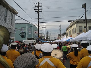
Central City is a neighborhood of the city of New Orleans. It is located in the 11th Ward of New Orleans in Uptown, just above the Garden District, on the "lakeside" of St. Charles Avenue. A subdistrict of the Central City/Garden District Area, its boundaries as defined by the City Planning Commission are: MLK Boulevard, South Claiborne Avenue and the Pontchartrain Expressway to the north, Magazine, Thalia, Prytania and Felicity Streets and St. Charles Avenue to the south and Toledano Street, Louisiana Avenue and Washington Avenue to the west. This old predominantly African-American neighborhood has been important in the city's brass band and Mardi Gras Indian traditions.

<span class="mw-page-title-main">16th Ward of New Orleans</span>

The 16th Ward or Sixteenth Ward is a division of the city of New Orleans, Louisiana, one of the 17 Wards of New Orleans. It is an Uptown ward, along with the adjacent 17th Ward, formerly part of the city of Carrollton, Louisiana which was annexed by New Orleans in the 1870s.

<span class="mw-page-title-main">12th Ward of New Orleans</span>

The 12th Ward or Twelfth Ward is a division of the city of New Orleans, Louisiana, one of the 17 Wards of New Orleans. The Ward was formerly part of the old Jefferson City annexed by New Orleans in 1870.

<span class="mw-page-title-main">13th Ward of New Orleans</span>

The 13th Ward or Thirteenth Ward is a division of the city of New Orleans, Louisiana. It is one of the 17 Wards of New Orleans. The Ward was formerly part of the old Jefferson City annexed by New Orleans in 1870.

<span class="mw-page-title-main">2006 New Orleans mayoral election</span>

The first round of the New Orleans mayoral election of 2006 took place on April 22, 2006; a runoff between incumbent Mayor Ray Nagin and Louisiana Lieutenant Governor Mitch Landrieu took place on May 20, resulting in reelection for Mayor Nagin. The Mayor of New Orleans is the top official in New Orleans' mayor-council system of government.

<span class="mw-page-title-main">Gentilly, New Orleans</span> New Orleans neighborhood in Louisiana, United States

Gentilly is a broad, predominantly middle-class and racially diverse section of New Orleans, Louisiana. The Gentilly neighborhood is bounded by Lake Pontchartrain to the north, France Road to the east, Bayou St. John to the west, and CSX Transportation railroad tracks to the south.

<span class="mw-page-title-main">New Orleans East</span> Eastern section of New Orleans

New Orleans East is the eastern section of New Orleans, the newest section of the city. It is bounded by the Industrial Canal, the Intracoastal Waterway and Lake Pontchartrain. Developed extensively from the 1950s onward, its numerous residential subdivisions and shopping centers offered suburban-style living within the city limits of New Orleans. Its overall character is decidedly suburban, resembling the archetypal postwar American suburb much more than the compactly-built environment found in the city's historic core.

<span class="mw-page-title-main">Sauvé's Crevasse</span>

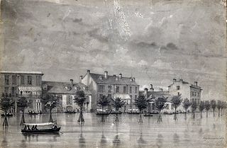
Sauvé's Crevasse was a Mississippi River levee failure in May 1849 that resulted in flooding much of New Orleans, Louisiana.

<span class="mw-page-title-main">Hollygrove, New Orleans</span> New Orleans Neighborhood in Louisiana, United States

Hollygrove is a neighborhood of the city of New Orleans, Louisiana, located in the city's 17th Ward. A subdistrict of the Uptown/Carrollton area, the boundaries as defined by the New Orleans City Planning Commission are the following: Palmetto Street to the north, Cambronne, Edinburgh, Forshey, Fig and Leonidas Streets to the east, Earhart Boulevard to the south and the Jefferson Parish boundary to the west. Conrad playground, the Cuccia-Byrnes playground and Larry Gilbert baseball stadium are located in Hollygrove. The Hollygrove Market and Farm is also located in Hollygrove. Particularly notable people, including rapper Lil Wayne, have grown up in the neighborhood.

<span class="mw-page-title-main">Claiborne Avenue</span>

Claiborne Avenue is a major thoroughfare in New Orleans, Louisiana. It runs the length of the city, about 9.5 miles (15.3 km), beginning at the Jefferson Parish line and ending at the St. Bernard Parish line; the street continues under different names in both directions. It is called South Claiborne Avenue upriver from Canal Street and North Claiborne Avenue from Canal to St. Bernard Parish.

<span class="mw-page-title-main">Leonidas, New Orleans</span> New Orleans Neighborhood in Louisiana, United States

Leonidas is a neighborhood designation in the city of New Orleans. A subdistrict of the Uptown/Carrollton Area, its boundaries as defined by the New Orleans City Planning Commission are: South Claiborne Avenue, Leonidas and Fig Streets to the north, South Carrollton Avenue to the east, the Mississippi River and Jefferson Parish to the west. Although an official city planning district name, the name "Leonidas" is not widely used nor has it any historical usage and the area is usually referred to by the larger neighborhood "Uptown, or "Carrollton".

<span class="mw-page-title-main">Fontainebleau, New Orleans</span> New Orleans Neighborhood in Louisiana, United States

Fontainebleau and Marlyville are jointly designated as a neighborhood of the city of New Orleans. A subdistrict of the Uptown/Carrollton Area, its boundaries as defined by the New Orleans City Planning Commission are: Colapissa and Broadway Streets and MLK Boulevard to the north, Norman C. Francis Parkway, Octavia Street, Fontainebleau Drive, Nashville Avenue, South Rocheblave, Robert and South Tonti Street and Jefferson Avenue to the east, South Claiborne Avenue, Lowerline and Spruce Streets to the south and South Carrollton Avenue to the west.

<span class="mw-page-title-main">Rosa F. Keller Library and Community Center</span>

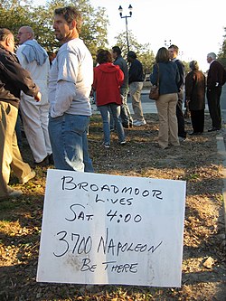
The Rosa F. Keller Library and Community Center is located in the Broadmoor neighborhood of New Orleans, Louisiana. It stands on the corner of Napoleon Avenue and South Broad Street which serve as the north/south, east/west markers in the neighborhood. The library is a branch of the greater New Orleans Public Library System. The Broadmoor branch serves as one of the only centers for community engagement in the neighborhood and hosts adult education classes, art workshops, after-school activities for children, and community events throughout the year. It opened its doors on March 17, 2012.

<span class="mw-page-title-main">LaToya Cantrell</span> 62nd Mayor of New Orleans

LaToya Cantrell is an American politician serving as the Mayor of New Orleans, Louisiana since May 7, 2018. A Democrat, Cantrell is the first woman to hold the office. Before becoming mayor, Cantrell represented District B on the New Orleans City Council from 2012–2018.

References

Notes

  1. 1 2 "National Register Information System". National Register of Historic Places . National Park Service. April 15, 2008.
  2. 1 2 3 4 Seidman, p. 61.
  3. "US Gazetteer files: 2010, 2000, and 1990". United States Census Bureau. February 12, 2011. Retrieved April 23, 2011.
  4. "US Board on Geographic Names". United States Geological Survey. October 25, 2007. Retrieved January 31, 2008.
  5. Greater New Orleans Community Data Center. "Broadmoor Neighborhood" . Retrieved October 19, 2007.
  6. 1 2 "Broadmoor Neighborhood". Greater New Orleans Community Data Center. Retrieved January 5, 2012.
  7. 1 2 3 Abramson, Larry. "New Orleans School Devastated By Katrina Reopens." National Public Radio . December 21, 2009. Retrieved on March 18, 2013.
  8. "Grand opening Saturday for Keller library in Broadmoor." Uptown Messenger . March 16, 2012. Retrieved on March 31, 2013.
  9. Sisco, Annette (April 1, 2012). "3 new libraries, destroyed after Katrina, reopen in a week's time". The Times-Picayune . Retrieved December 11, 2016.
  10. "NOPL Centennial Exhibit: Extension". nutrias.org. Retrieved April 23, 2020.
  11. Bruno, R. Stephanie. "Renovations to New Orleans area libraries bring them into 21st century." The Times-Picayune . June 24, 2011. Retrieved on March 31, 2013.
  12. "David Louis "Dave" Bartholomew Obituary (1918 - 2019) the Times-Picayune".