
Chapel Hill is a town in Orange and Durham counties in the U.S. state of North Carolina. Its population was 57,233 in the 2010 census, making Chapel Hill the 15th-largest city in the state. Chapel Hill, Durham, and the state capital, Raleigh, make up the corners of the Research Triangle, with a total population of 1,998,808.

Yadkin County is located in the U.S. state of North Carolina. As of the 2010 census, the population was 38,406. Its county seat is Yadkinville.

Davidson County is a county located in the U.S. state of North Carolina. As of the 2010 census, the population was 162,878. Its county seat is Lexington, and its largest city is Thomasville.

Morganton is a city in and the county seat of Burke County, North Carolina, United States. The population was 16,918 at the 2010 census.

Cullowhee is a census-designated place (CDP) in Jackson County, North Carolina, United States. It is located on the Tuckasegee River, and the permanent population was 6,228 as of the 2010 census.

Wilmington is a port city and the county seat of New Hanover County in coastal southeastern North Carolina, United States.

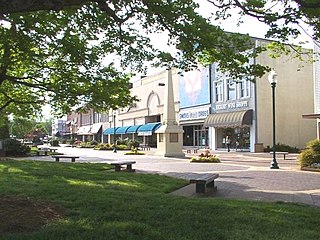
Liberty is a town in Randolph County, North Carolina, United States.

Wake Forest is a town in Franklin and Wake counties in the U.S. state of North Carolina; located almost entirely in Wake County, it lies just north of the state capital, Raleigh. The population was 30,117 at the 2010 census, up from 12,588 at the 2000 census. The U.S. Census Bureau estimates the city's population to be 45,629 as of July 1, 2019. In 2007, the town was listed by Forbes magazine as the 20th fastest growing suburb in America, with a 73.2 percent increase in population between 2000 and 2006. Wake Forest was the original home of Wake Forest University for 122 years before it moved to Winston-Salem in 1956.

Mebane is a city located mostly in Alamance County, North Carolina, United States, and partly in Orange County, North Carolina. The town was named for Alexander Mebane, an American Revolutionary War general and member of the U.S. Congress. It was incorporated as "Mebanesville" in 1881, and in 1883 the name was changed to "Mebane". It was incorporated as a city in 1987. The population as of the 2010 census was 11,393. Mebane is one of the fastest growing municipalities in North Carolina. Mebane straddles the Research Triangle and Piedmont Triad Regions of North Carolina. The Alamance County portion is part of the Burlington Metropolitan Statistical Area, which is a component of the Greensboro-Winston-Salem-High Point Combined Statistical Area. The Orange County portion is part of the Durham-Chapel Hill Metropolitan Statistical Area, which is a component of the Raleigh-Durham-Chapel Hill Combined Statistical Area.
Hickory is a city located primarily in Catawba County, with formal boundaries extending into Burke and Caldwell counties. The city lies in the U.S. state of North Carolina. Hickory's population at the 2010 census was 40,010, with an estimated population in 2019 of 41,171. Hickory is the principal city in the Hickory–Lenoir–Morganton MSA, in which the population at the 2010 census was 365,497 and is located just northwest of the Charlotte–Concord Combined Statistical Area.
New Hill is an unincorporated community located in southwestern Wake County, North Carolina, at the crossroads of old U.S. 1, New Hill Olive Chapel Road and New Hill Holleman Road. New Hill is located along the original alignment of the New Hope Valley Railway between Durham and Bonsal.

The Virginia Park Historic District is located on the north side of New Center, an area in Detroit, Michigan, along both sides of Virginia Park Street from Woodward Avenue to the John C. Lodge Freeway access road. The district was listed on the National Register of Historic Places in 1982.
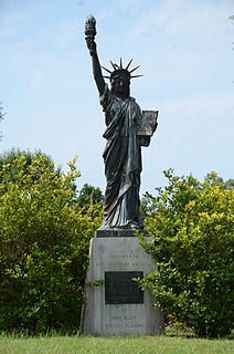
The Strengthen the Arm of Liberty Monument is a replica of the Statue of Liberty in Pine Bluff Memorial Gardens, on the south side of 10th Avenue between Georgia and State Street in Pine Bluff, Arkansas. It was placed by the Boy Scouts of America (BSA) as part of its 1950s era campaign, "Strengthen the Arm of Liberty." The statue is 8 feet (2.4 m) in height, made of copper, and is mounted on concrete base 3.5 feet (1.1 m) tall. The statue faces north, toward the Pine Bluff Civic Center, and there is a bronze commemorative plaque on the north face of the base. It is one of two BSA-placed statues in the state; the other is in Fayetteville.

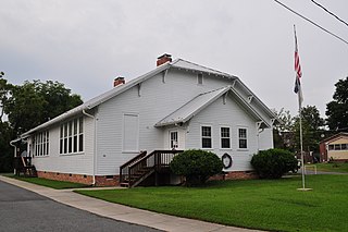
Liberty Colored High School is a former high school for African-American students in Liberty, South Carolina during the period of racial segregation. It originally was called Liberty Colored Junior High School. The building is now a community center known as the Rosewood Center. It is at East Main Street and Rosewood Street in Liberty. The school was built in 1937 on the site of a Rosenwald school that had burned down. Because of its role in the education of local African-American students, it was named to the National Register of Historic Places on April 18, 2003.
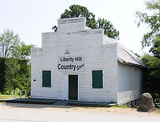
Liberty Hill Historic District is a national historic district located at Liberty Hill, Kershaw County, South Carolina. The district encompasses 34 contributing buildings and 2 contributing structure in the small rural community of Liberty Hill. The district includes several imposing Greek Revival structures, Greek Revival cottages, and an 1880s vernacular Gothic Revival church. The later, turn of the 20th century residences are primarily one-story, simple clapboard cottages. The town's history begins as early as ca. 1813 when Peter Garlick's store was a gathering place for surrounding farmers. Soon, impressive structures were built by planters in the area. Remaining from the 1830s are Cool Spring and the Joseph Cunningham House. The majority of the town's antebellum buildings, however, were built ca. 1840–1850. During this period Liberty Hill was a very wealthy community. However, the final days of the American Civil War ended that prosperity. Nevertheless, the town did eventually reassert itself and appears to have changed very little since the beginning of the 20th century.
Nununyi was a historic village of the Cherokee people in western North Carolina, located on the eastern side of the Oconaluftee River. Today it is within the boundaries of the present-day city of Cherokee in Swain County. It was classified by English traders and colonists as among the "Out Towns" of the Cherokee in this area east of the Appalachian Mountains.
Walnut Cove Colored School, also known as London School, is historic Rosenwald School located at Walnut Cove, Stokes County, North Carolina. It was built in 1921 with a grant from Sears & Roebuck financier, Julius Rosenwald. A condition of the grant was that it had to have local matching funds. Therefore, it was built on land donated by John William Dalton and his brother George Samuel Dalton and with materials provided by The Dan River Lumber Company.
Liberty Hill is an unincorporated community in Kershaw County, South Carolina, United States. The community is located at the junction of South Carolina Highway 97 and South Carolina Highway 522, 19.5 miles (31.4 km) northwest of Camden. Liberty Hill has a post office with ZIP code 29074, which opened on January 19, 1818.


