Related Research Articles

King Philip's War was an armed conflict in 1675–1676 between a group of indigenous peoples of the Northeastern Woodlands, the English New England Colonies and their indigenous allies. The war is named for Metacom, the Pokanoket chief and sachem of the Wampanoag who adopted the English name Philip because of the friendly relations between his father Massasoit and the Plymouth Colony. The war continued in the most northern reaches of New England until the signing of the Treaty of Casco Bay on April 12, 1678.
The Massachusett language is an Algonquian language of the Algic language family that was formerly spoken by several peoples of eastern coastal and southeastern Massachusetts. In its revived form, it is spoken in four communities of Wampanoag people. The language is also known as Natick or Wôpanâak (Wampanoag), and historically as Pokanoket, Indian or Nonantum.

The Algonquians are one of the most populous and widespread North American native language groups. They historically were prominent along the Atlantic Coast and in the interior regions along Saint Lawrence River and around the Great Lakes. This grouping consists of the peoples who speak Algonquian languages.
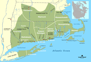
The Nipmuc or Nipmuck people are an Indigenous people of the Northeastern Woodlands, who historically spoke an Eastern Algonquian language. Their historic territory Nippenet, "the freshwater pond place," is in central Massachusetts and nearby parts of Connecticut and Rhode Island.
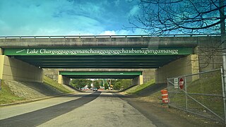
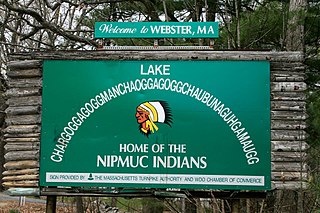
Lake Chaubunagungamaug, also known as Webster Lake, is a lake in the town of Webster, Massachusetts. It is located near the Connecticut border and has a surface area of 1,442 acres. Since 1921, the lake has also been known by a much longer name having 45 letters comprising fourteen syllables: Lake Chargoggagoggmanchauggagoggchaubunagungamaugg. The lake has become famous beyond Central Massachusetts for having the longest name of any geographic feature in all of the United States.
Indigenous peoples of the Northeastern Woodlands include Native American tribes and First Nation bands residing in or originating from a cultural area encompassing the northeastern and Midwest United States and southeastern Canada. It is part of a broader grouping known as the Eastern Woodlands. The Northeastern Woodlands is divided into three major areas: the Coastal, Saint Lawrence Lowlands, and Great Lakes-Riverine zones.

The Woonasquatucket River is a river in the U.S. state of Rhode Island. It flows approximately 15.8 miles (25.4 km) and drains a watershed of 130 km2 (50 sq mi).

Dug Pond is a small body of water in Natick, Massachusetts. Most notably it is home to Memorial Beach, one of few swimming beaches in Natick, and its eastern shore is the site of Natick High School.

The Millers River is a 52.1-mile-long (83.8 km) river in northern Massachusetts, originating in Ashburnham and joining the Connecticut River just downstream from Millers Falls, Massachusetts. Sections of the river are used for whitewater kayaking, and a section upriver is popular with flatwater racers, and the river is known locally as a good place for pike fishing.
The Webster/Dudley Band of Chaubunagungamaug Nipmuck Indians, also known as the Chaubunagungamaug, Chaubunagungamaug Nipmuck, Pegan or Dudley/Webster Indians, is a cultural heritage group that claims descent from the Nipmuc people. They are a state-recognized tribe by the Commonwealth of Massachusetts.
The Nashaway were a tribe of Algonquian Indians inhabiting the upstream portions of the Nashua River valley in what is now the northern half of Worcester County, Massachusetts, mainly in the vicinity of Sterling, Lancaster and other towns near Mount Wachusett, as well as southern New Hampshire. The meaning of Nashaway is "river with a pebbled bottom".

Winnecunnet Pond or Winneconnet Pond or Winnecunnett Pond, very often called Lake Winnecunnet or Lake Winneconnet or Lake Winnecunnett although it is a pond rather than a lake, is a body of water in Norton, Massachusetts, United States.
Native American tribes in Massachusetts are the Native American tribes and their reservations that existed historically and those that still exist today in what is now the Commonwealth of Massachusetts. A Narragansett term for this region is Ninnimissinuok.

The Battle of Turner's Falls or Battle of Grand Falls; also known as the Peskeompscut-Wissantinnewag Massacre, was a battle and massacre occurring on May 19, 1676, in the context of King Philip's War in what is present-day Gill and Greenfield, across from Turners Falls on the Connecticut River. The incident marked a turning point in the war, and in the colonization of Native lands by British settlers. The war led to the expulsion of most Native Americans in the Connecticut River Valley.
Quinsigamond is a place in Massachusetts.
The Massachusett dialects, as well as all the Southern New England Algonquian (SNEA) languages, could be dialects of a common SNEA language just as Danish, Swedish and Norwegian are mutually intelligible languages that essentially exist in a dialect continuum and three national standards. With the exception of Massachusett, which was adopted as the lingua franca of Christian Indian proselytes and survives in hundreds of manuscripts written by native speakers as well as several extensive missionary works and translations, most of the other SNEA languages are only known from fragmentary evidence, such as place names. Quinnipiac (Quiripey) is only attested in a rough translation of the Lord's Prayer and a bilingual catechism by the English missionary Abraham Pierson in 1658. Coweset is only attested in a handful of lexical items that bear clear dialectal variation after thorough linguistic review of Roger Williams' A Key into the Language of America and place names, but most of the languages are only known from local place names and passing mention of the Native peoples in local historical documents.
References
Citations
- 1 2 Salwen, Bert, 1978. Indians of Southern New England and Long Island: Early Period. In "Northeast", ed. Bruce G. Trigger. Vol. 15 of "Handbook of North American Indians", ed. William C. Sturtevant, pp. 160–176. Washington D.C.: Smithsonian Institution. Quoted in: Campbell, Lyle. 1997. American Indian Languages: The Historical Linguistics of Native America. Oxford: Oxford University Press, pg. 401
- ↑ "Nissitissit River Land Trust". nissitissitriver.org. Retrieved 2021-11-27.
- ↑ Nashua River Wild & Scenic Study Committee (November 29, 2017). "DRAFT STEWARDSHIP PLAN" (PDF).
Sources
- Bright, William (2004). Native American Placenames of the United States. Norman: University of Oklahoma Press. ISBN 080613576X.