This article relies largely or entirely on a single source .(September 2020) |
List of archaeological sites in County Tyrone, Northern Ireland:
This article relies largely or entirely on a single source .(September 2020) |
List of archaeological sites in County Tyrone, Northern Ireland:
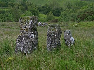
Drumskinny is the site of a stone circle in the townland of Drumskinny, County Fermanagh, Northern Ireland. With the inclusion of an adjacent cairn and alignment, the stone circle is a State Care Historic Monument in Fermanagh and Omagh district, at grid ref: H 2009 7072. The site was excavated in 1962 and is believed to have built around 2000 BC.

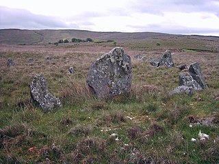
Beaghmore is a complex of early Bronze Age megalithic features, stone circles and cairns, 8.5 miles north west of Cookstown, County Tyrone in Northern Ireland, on the south-east edge of the Sperrin Mountains.

Knocknakilla is the site of a megalithic complex situated between Macroom and Millstreet, in County Cork, Ireland. It is set in blanket peatland on the north-west upper slopes of Musherabeg mountain and is thought to be 3500 years old.


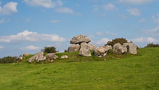
Glantane East is a megalithic complex situated 6.4 kilometres (4.0 mi) from Millstreet, County Cork, Ireland. It is set in the Keel River valley on the north-west upper slopes of Musherabeg mountain, in the townland of Glantane. The complex includes a wedge tomb, two stone circles and a pair of stone alignments.

Aghanaglack or Aghnaglack, is a townland in County Fermanagh, Northern Ireland. It is situated in the civil parish of Boho, as well as Fermanagh and Omagh district.

Ault,, is a townland of 367 acres in County Antrim, Northern Ireland. It is situated in the civil parish of Tickmacrevan and the historic barony of Glenarm Lower.

Glenmacoffer is a townland in County Tyrone, Northern Ireland. It is situated in the barony of Strabane Upper and the civil parish of Bodoney Lower and covers an area of 2703 acres.

Radergan is a townland in County Tyrone, Northern Ireland. It is situated in the barony of Omagh East and the civil parish of Clogherny and covers an area of 919 acres.

Reaghan is a townland in County Tyrone, Northern Ireland. It is situated in the barony of Strabane Upper and the civil parish of Cappagh and covers an area of 567 acres.
Carricknagat Megalithic Tombs are megalithic tombs and a National Monument located in County Sligo, Ireland.
The main reference for all sites listed is: NI Environment Agency, Scheduled Historic Monuments (to 15 October 2012), unless otherwise indicated.