
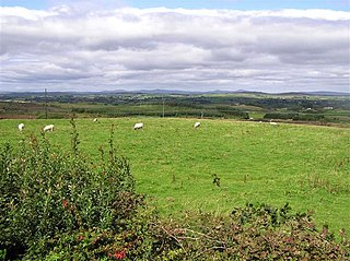
Aughnacloy, sometimes spelt Auchnacloy, is a village in County Tyrone, Northern Ireland. Close to the border with County Monaghan in the Republic of Ireland, the village is about 20 km southwest of Dungannon, and 7 km southeast of Ballygawley. It is situated in the historic barony of Dungannon Lower and the civil parish of Carnteel. In the 2011 census it had a population of 1,045.

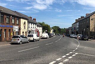
Ballygawley or Ballygawly is a small town in County Tyrone, Northern Ireland. It is about 20 kilometres southwest of Dungannon, near the meeting of the A5 Derry–Dublin and A4 Dungannon–Enniskillen roads.

Ballymagorry or Ballymagory is a small village and townland in County Tyrone, Northern Ireland. It is west of Artigarvan and 5 kilometres (3.1 mi) north of Strabane. In the 2001 Census it had a population of 565. It lies within the Strabane District Council area and lies on the River Glenmornan.
Donaghmore is a village, townland and civil parish in County Tyrone, Northern Ireland, about five kilometres (3 mi) north-west of Dungannon. In the 2011 Census it had a population of 1,122 people. The village is beside the River Torrent, formerly known as the Torrent Flow.

Caledon is a small village and townland in County Tyrone, Northern Ireland. It is in the Clogher Valley on the banks of the River Blackwater, 10 km from Armagh. It lies in the southeast of Tyrone and near the borders of County Armagh and County Monaghan. It is situated in the historic barony of Dungannon Lower and the civil parish of Aghaloo. In the 2001 Census it had a population of 387 people. It is a designated conservation area. It was historically known as Kinnaird.
Shanmaghery or Shanmaghry is a small hamlet and townland in County Tyrone, Northern Ireland, situated three miles from Pomeroy and three miles from Galbally. It is situated in the barony of Dungannon Middle and the civil parish of Pomeroy and covers an area of 426 acres. In 1841 the population of the townland was 193 people and in 1851 it was 161 people. "Paul's Planting" was a notable landmark on top of the hill.

Brackaville or Bracaville is a village and townland near Coalisland in County Tyrone, Northern Ireland. It is situated in the historic barony of Dungannon Middle and the civil parish of Donaghenry and covers an area of 235 acres on the western side of Lough Neagh.
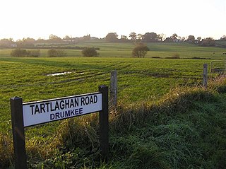
Drumkee is a townland in the southeast of County Tyrone, Northern Ireland. It is directly south of the area presently known as Coalisland and east, and slightly north, of Dungannon. It is situated in the historic barony of Dungannon Middle and the civil parish of Killyman and covers an area of 285 acres. The barony's tax records dated 1666 list two families living in Drumkee.
Ballygittle is a townland in County Tyrone, Northern Ireland. It is situated in the historic barony of Dungannon Middle and the civil parish of Clonoe and covers an area of 169 acres. It is close to Stewartstown.

Derrytresk is a townland outside Coalisland, County Tyrone, Northern Ireland and is close to the shores of Lough Neagh. It is situated in the historic barony of Dungannon Middle and the civil parish of Clonoe and covers an area of 1020 acres. Derrytresk consists of sub-townlands: Derryvarne, Derrykiltena and Derrynahaskila.
Ballymully Glebe is a townland in County Tyrone, Northern Ireland. It is situated in the historic barony of Dungannon Upper and the civil parish of Desertcreat and covers an area of 144 acres.
Desertcreat is a parish and a townland in County Tyrone, Northern Ireland. The civil parish of Desertcreat is in the eastern part of County Tyrone in the barony Dungannon Upper, immediately south of the parish of Derryloran, which contains the town of Cookstown, and immediately north of the parish of Pomeroy. The parish has a Church of Ireland Church in the townland of Desertcreat. Patrick Donnelley, the Roman Catholic Bishop who was known as Phelim Brady or the 'Bard of Armagh', is buried in the church graveyard.

Donaghey is a small village and townland roughly halfway between Cookstown and Dungannon, just off the A29, in County Tyrone, Northern Ireland.
Branny is a townland in County Tyrone, Northern Ireland. It is situated in the historic barony of Dungannon Lower and the civil parish of Carnteel and covers an area of 228 acres.
Crannogue is a townland in County Tyrone, Northern Ireland. It is situated in the historic barony of Dungannon Middle and the civil parish of Pomeroy and covers an area of 759 acres.
Gortalowry is a townland in County Tyrone, Northern Ireland. It is situated in the barony of Dungannon Upper and the civil parish of Derryloran and covers an area of 281 acres. The townland is partly rural, but includes the southern part of the town of Cookstown.
Lisgobban is a townland in County Tyrone, Northern Ireland. It is situated in the barony of Dungannon Middle and the civil parish of Clonfeacle and covers an area of 135 acres.
Derrycrin (Conyngham) is a townland in County Tyrone, Northern Ireland. It is situated in the historic barony of Dungannon Upper and the civil parish of Ballinderry and covers an area of 515 acres.
Derrycrin (Eglish) is a townland in County Tyrone, Northern Ireland. It is situated in the historic barony of Dungannon Upper and the civil parish of Ballinderry and covers an area of 444 acres.
Derryloughan is a townland in County Tyrone, Northern Ireland. It lies on the southwest corner of Lough Neagh, 4 miles from Coalisland. It is situated in the historic barony of Dungannon Middle and the civil parish of Clonoe and covers an area of 1751 acres.

