Related Research Articles

Mer Bleue Bog is a 33.43 km2 (12.91 sq mi) protected area in Gloucester, Ontario, an eastern suburb of Ottawa in Eastern Ontario, Canada. Its main feature is a sphagnum bog that is situated in an ancient channel of the Ottawa River and is a remarkable boreal-like ecosystem normally not found this far south. Stunted black spruce, tamarack, bog rosemary, blueberry, and cottongrass are some of the unusual species that have adapted to the acidic waters of the bog.
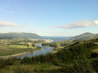
Carlingford Lough is a glacial fjord or sea inlet in northeastern Ireland, forming part of the border between Northern Ireland to the north and the Republic of Ireland to the south. On its northern shore is County Down, the Mourne Mountains, and the town of Warrenpoint; on its southern shore is County Louth, the Cooley Mountains and the village of Carlingford. The Newry River flows into the loch from the northwest.

Burns Bog is an ombrotrophic peat bog located in Delta, British Columbia, Canada. It is the largest raised peat bog and the largest undeveloped urban land mass on the West Coast of the Americas. Burns Bog was originally 4,000–4,900 hectares before development. Currently, only 3,500 hectares remain of the bog.

Belfast Lough is a large, intertidal sea inlet on the east coast of Northern Ireland. At its head is the city and port of Belfast, which sits at the mouth of the River Lagan. The lough opens into the North Channel and connects Belfast to the Irish Sea.
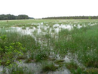
Ballynahone Bog is a raised bog, situated in County Londonderry, Northern Ireland, about 3 km south of Maghera, on low-lying ground immediately north of the Moyola River about 14 km from its mouth at Lough Neagh. It is one of the largest lowland raised bogs in Northern Ireland.
The Čepkeliai Marsh is the largest bog in Lithuania. Located in Varėna District Municipality, south of Marcinkonys village and north of Kotra River, which flows along the Belarus–Lithuania border in this area. Its area is a nature reserve and a Ramsar site.

Cuilcagh is a mountain on the border between County Fermanagh and County Cavan. With a height of 665 metres (2,182 ft) it is the highest point in both counties. It is also the 170th highest peak on the island of Ireland, and Ireland's only cross-border county top. Water from the southern slope flows underground until it emerges some miles away in the Shannon Pot, the traditional source of the River Shannon. The area is sometimes referred to as the Cuilcagh Mountains.

Kushiro-Shitsugen National Park is a national park located in the east of the island of Hokkaido, Japan. It was designated as a national park on 31 July 1987. The park is known for its wetlands ecosystems.
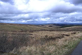
Slieve Beagh is a mountainous area straddling the border between County Monaghan in the Republic of Ireland and County Fermanagh and County Tyrone in Northern Ireland. A point just east of its summit is the highest point in Monaghan; however the true summit is on the Fermanagh-Tyrone border. The point where the three counties meet, is referred to as the "Three County Hollow".
Clara Bog is one of the largest relatively intact raised bogs remaining in Ireland. It lies southeast of the R436 regional road between the village of Ballycumber and the town of Clara, in County Offaly. Much of the bog is state-owned and managed as a nature reserve covering some 460 ha. A Special Area of Conservation covers 836 ha.
Thursley Common is a national nature reserve in Surrey, England, and has also been designated as a Ramsar wetland. It is also part of a Site of Special Scientific Interest called Thursley, Hankley and Frensham Commons.
Alam-Pedja Nature Reserve is the largest nature reserve in Estonia. It is a vast wilderness area which covers 342 km2 and consists of a complex of 5 large bogs separated by unregulated rivers, their floodplains, and extensive forests. The nature reserve aims to protect diverse ecosystems and rare species, mainly through preserving the natural development of forests and bogs and securing the continuing management of semi-natural floodplain grasslands.

The Cuilcagh Lakelands Geopark formerly known as the Marble Arch Caves Global Geopark straddles the border between Northern Ireland and the Republic of Ireland. It is centred on the Marble Arch Caves and in 2001 it became one of the first geoparks to be designated in Europe.
Kokorou or Kokoro is a town and rural commune in the Téra Department of western Niger.
Toolibin Lake is a seasonal fresh to brackish water perched lake or wooded swamp, in south-western Australia. The lake is contained with a 493-hectare (1,218-acre) nature reserve and it is located about 200 kilometres (124 mi) south-east of Perth, in the Shire of Narrogin, and 40 kilometres (25 mi) east of the town of Narrogin, in the Wheatbelt region of Western Australia. The lake is listed by the Australian Government as a threatened ecological community under the Environment Protection and Biodiversity Conservation Act 1999.
Raheenmore Bog is a raised bog north-west of Daingean, County Offaly, in Ireland. Since the 1980s the greater part of the bog has been maintained as a 162 hectare Nature Reserve, which is currently managed by the National Parks and Wildlife Service. A Special Area of Conservation covers 182 ha, including some land in private ownership.

Meshchyorsky National Park covers extensive wetlands and pine/birch woodlands in the Meshchera Lowlands on the East European Plain in the northern section of Ryazan Oblast, Russia, about 120 km east of Moscow. The wetland habitat provides for extremely rich biodiversity among the plants and animals. "Meshchersky" (Мещёрский) National Park is not to be confused with "Meshchyora" (Мещёра) National Park, which is just to the north, over the border in Vladimir Oblast. The park protects a section of the Pra River, Lake Beloye, and associated wetlands and forests. About 54% of the park territory is used and managed for agricultural purposes by local communities.
North Cove is a 15.5 hectare nature reserve between Beccles and Lowestoft in Suffolk. It is managed by the Suffolk Wildlife Trust. t is part of the Barnby Broad and Marshes Site of Special Scientific Interest the Broadland Ramsar internationally important wetland site, the Broadland Special Protection Area under the European Union Directive on the Conservation of Wild Birds, and The Broads Special Area of Conservation.
References
- ↑ "Black Bog". Ramsar Sites Information Service. Archived from the original on 27 February 2017. Retrieved 25 April 2018.
- 1 2 "Designated and Proposed Ramsar sites in Northern Ireland" (PDF). Joint Nature Conservation Committee. Archived (PDF) from the original on 28 July 2008. Retrieved 7 July 2008.
- ↑ "Black Bog Ramsar site". NI Environment Agency. Archived from the original on 20 June 2010. Retrieved 7 July 2008.
- ↑ Information Sheet on Ramsar Wetlands (RIS). Black Bog (PDF). Ramsar. May 2005.