
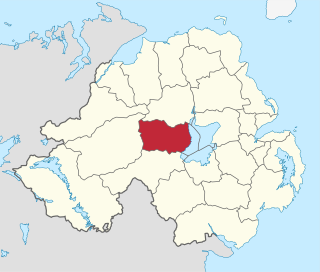
Tullyhogue, also called Tullaghoge or Tullahoge, is a small village and townland in County Tyrone, Northern Ireland. It is within the civil parish of Desertcreat and is about two miles or three kilometres south of Cookstown.
Cookstown District Council was a district council covering an area largely in County Tyrone and partly in County Londonderry. It merged with Dungannon and South Tyrone Borough Council and Magherafelt District Council in May 2015 under local government reorganisation in Northern Ireland to become Mid-Ulster District Council.

Loughmacrory is a village and townland in County Tyrone, Northern Ireland. The village is situated 8 miles (13 km) east of Omagh in the historic barony of Omagh East and the civil parish of Termonmaguirk. it had a population of 237 in the 2001 Census. Loughmacrory has houses, shops, a church and a primary school. There is also an old mill and ancient cairns nearby.

Annahugh is a small village and townland near Loughgall in County Armagh, Northern Ireland. While most of the settlement is within the townland of Annahugh, part of it extends into the neighbouring townland of Ballyhagan. Hence, the two names are sometimes used to refer to the same settlement. It is situated within the Armagh City and District Council area. It had a population of 275 people in the 2011 Census.
Broomhill is a small village in County Armagh, Northern Ireland. It is within the townland of Drumnahunshin and the Armagh City and District Council area. It had a population of 197 people in the 2011 Census.

Carrickaness is a small village and townland in County Armagh, Northern Ireland. In the 2001 Census it had a population of 99 people. It is within the Armagh City and District Council area.

Cladymore or Clady More is a small village and townland in County Armagh, Northern Ireland. It is within the Armagh City and District Council area. It had a population of 139 people in the 2011 Census.
Edenaveys is a small village and townland in County Armagh, Northern Ireland. It lies southeast of Armagh and is within the Armagh City and District Council area. Historically, it has been anglicized as Edenafeagh amongst other variations. It had a population of 190 people in the 2011 Census.

Loughgilly is a small village, townland and civil parish in County Armagh, Northern Ireland. It is on the main Armagh to Newry road, about halfway between the two. It is within the Armagh City and District Council area. It had a population of 84 people in the 2011 Census.
Dunnaval is a small village and townland near Kilkeel in County Down, Northern Ireland. It is situated in the civil parish of Kilkeel and the historic barony of Mourne. In the 2001 Census it had a population of 147 people. It lies within the Newry and Mourne District Council area.

Killowen, alternatively spelt Cill Abhainn is a small village in County Down, Northern Ireland. It is near Rostrevor and on the shore of Carlingford Lough. In the 2001 Census it had a population of 159 people. It lies within the Newry and Mourne District Council area.

Mullaghglass is a small village and townland north of Newry in County Armagh, Northern Ireland. It was named after the nearby townland of Mullaghglass, although the village itself is within the townland of Latt. In the 2001 Census it had a population of 135. It is within the Newry and Mourne District Council area.
Sheeptown is a small village and townland in County Down, Northern Ireland. It lies to the northeast of Newry, on the old road between Newry and Rathfriland. Historically, the townland was called Athcruthain. In the 2001 Census it had a population of 204 people. It is part of the Newry and Mourne District Council area.

Craigarogan is a small village, electoral division and townland to the west of Newtownabbey in County Antrim, Northern Ireland. The settlement has developed at the junction of the Bernice Road and the Clarke Lodge Road. The settlement of Roughfort is also within the townland. In the 2001 Census it had a population of 69 people. It is part of Antrim and Newtownabbey district.
Clanabogan is a small village and townland in County Tyrone, Northern Ireland. In the 2001 Census it had a population of 225 people. It lies within the Omagh District Council area.

Gortaclare is a small village and townland in County Tyrone, Northern Ireland. In the 2001 Census it had a population of 66 people. It lies within the Omagh District Council area.

Rousky is a small village and townland in the Sperrins of County Tyrone, Northern Ireland. In the 2001 Census it had a population of 81. Rousky is on the main road between Gortin and Greencastle. It lies within the parish of Badoney Lower, the barony of Strabane Upper and the Omagh District Council area.
Derrycrin or Derrychrin, is a small village in County Tyrone, Northern Ireland. It is part of the parish of Ballinderry and is near the western shore of Lough Neagh. The Ballinderry River is a short distance north of the village and marks the boundary between counties Tyrone and Londonderry.
Aughafatten or Aghafatten is a small village and townland between Carnlough and Broughshane in County Antrim, Northern Ireland. It is in Mid and East Antrim District Council and part of the North Antrim constituency for local and European elections. It enjoys an excellent view of Slemish mountain.

The Bricklieve Mountains or Bricklieve Hills are a range of hills in south County Sligo, Ireland. They are dotted with ancient passage tombs known as the Carrowkeel tombs or Bricklieve tombs. The name of the hills is a possible reference to their appearance when more quartz rock survived outside the cairns, making them sparkle in the sun. The hills cover an area of 25 square kilometres (9.7 sq mi) and include only two major hills, Carrowkeel at 321 metres (1,053 ft), and Kesh Corann at 359 metres (1,178 ft). The Caves of Kesh are on the west side of Kesh Corran.