Drumkee

Last updated

Drumkee
Tartlaghan Road - geograph.org.uk - 275095.jpg
Drumkee townland in 2006
United Kingdom Northern Ireland adm location map.svg
Red pog.svg
Drumkee
Location within Northern Ireland
County
Country Northern Ireland
Sovereign state United Kingdom
Postcode district BT71
Dialling code 028
List of places
UK
Northern Ireland
Tyrone
54°30′36″N6°40′30″W / 54.510°N 6.675°W / 54.510; -6.675

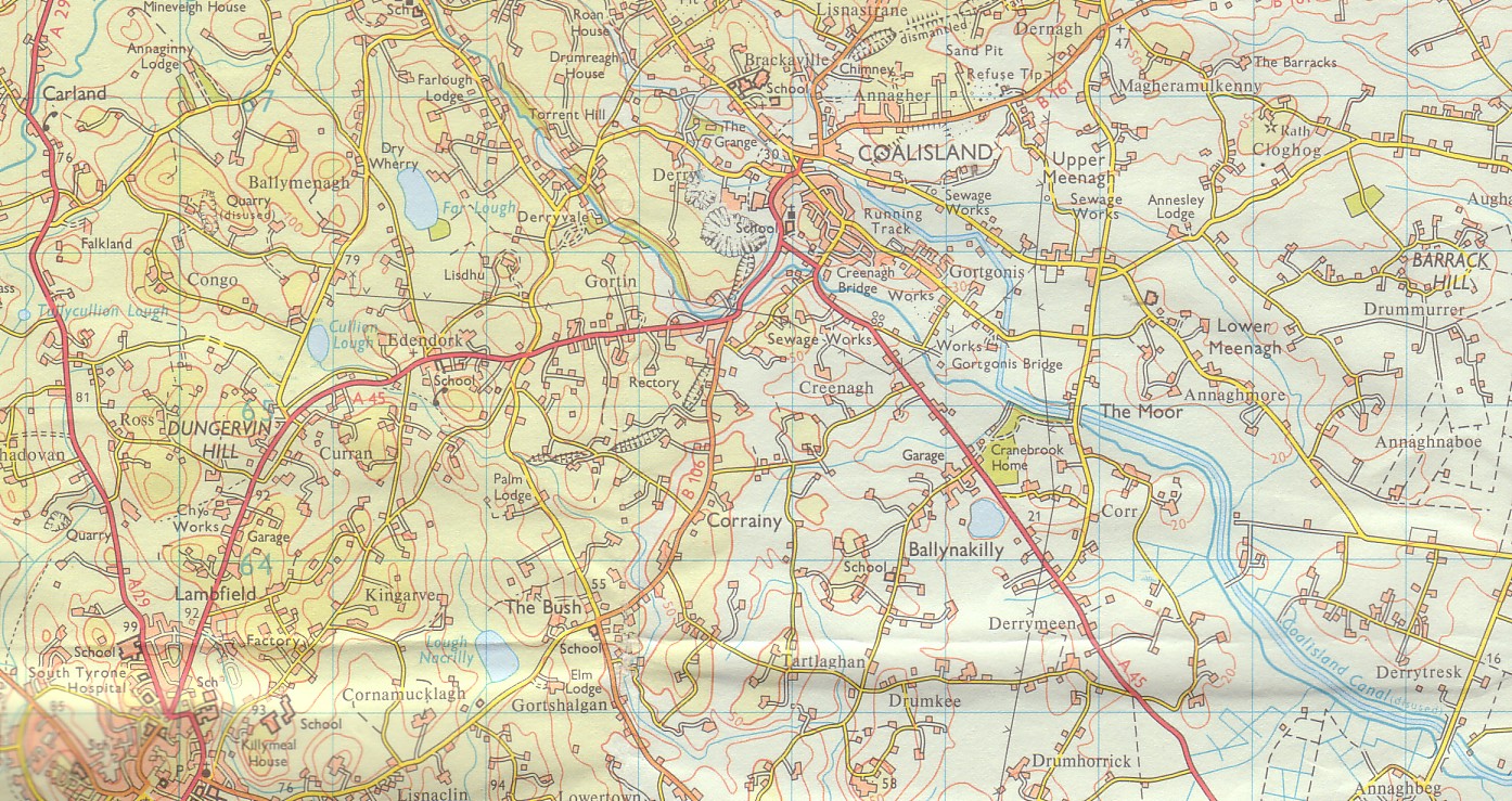
Drumkee is a townland in the southeast of County Tyrone, Northern Ireland. It is directly south of the area presently known as Coalisland [1] and east, and slightly north, of Dungannon. [2] It is situated in the historic barony of Dungannon Middle and the civil parish of Killyman and covers an area of 285 acres. [3] The barony's tax records dated 1666 list two families living in Drumkee. [4]

Contents

The name derives from the Irish: Druim Chaoich (Ridge of the Blind Man) or Druim Ceath (ridge of western aspect). [5]

Population

The population of the townland declined during the 19th century: [6] [7]

Year184118511861187118811891
Population350184168145127111
Houses703938312928

Drumkee presently has a population of around 150, and many of its inhabitants are relations.[ citation needed ] Surnames which appear on the 1666 list include McRory and Condson. [4] By the mid-19th century, the name Hunter appears in Drumkee burial records. [8] The surname Mullan appears in a 1910 directory of the area. [9]

See also

Related Research Articles

<span class="mw-page-title-main">Dungannon</span> Town in County Tyrone, Northern Ireland

Dungannon is a town in County Tyrone, Northern Ireland. It is the second-largest town in the county and had a population of 16,282 at the 2021 Census. The Dungannon and South Tyrone Borough Council had its headquarters in the town, though since 2015 the area has been covered by Mid-Ulster District Council.

<span class="mw-page-title-main">Carrickmore</span> Village in County Tyrone, Northern Ireland

Carrickmore is a small town in County Tyrone, Northern Ireland. It is situated in the historic barony of Omagh East, the civil parish of Termonmaguirk and the Roman Catholic Parish of Termonmaguirc between Cookstown, Dungannon and Omagh. It had a population of 612 in the 2001 Census. In the 2011 Census 2,330 people lived in the Termon Ward, which covers the Carrickmore and Creggan areas.

<span class="mw-page-title-main">Caledon, County Tyrone</span> Village in County Tyrone, Northern Ireland

Caledon is a small village and townland in County Tyrone, Northern Ireland. It is in the Clogher Valley on the banks of the River Blackwater, 10 km from Armagh. It lies in the southeast of Tyrone and near the borders of County Armagh and County Monaghan. It is situated in the historic barony of Dungannon Lower and the civil parish of Aghaloo. In the 2001 Census it had a population of 387 people. It is a designated conservation area. It was historically known as Kinnaird.

Cappagh is a small village and townland in the parish of Pomeroy in County Tyrone, Northern Ireland. Around 10 kilometres (6 mi) north-west of Dungannon, it is between Pomeroy, Ballygawley, Galbally and Carrickmore, with the hamlet of Galbally about one mile to the east. Most of the land around Cappagh is farmland although a quarry lies just outside the village. In County Tyrone, there is also the parish of Cappagh which includes part of the town of Omagh and small village of Mountfield.

<span class="mw-page-title-main">Shanmaghery</span> Hamlet in County Tyrone, Northern Ireland

Shanmaghery or Shanmaghry is a small hamlet and townland in County Tyrone, Northern Ireland, situated three miles from Pomeroy and three miles from Galbally. It is situated in the barony of Dungannon Middle and the civil parish of Pomeroy and covers an area of 426 acres. In 1841 the population of the townland was 193 people and in 1851 it was 161 people. "Paul's Planting" was a notable landmark on top of the hill.

<span class="mw-page-title-main">Brackaville</span> Village and townland in County Tyrone, Northern Ireland

Brackaville or Bracaville is a village and townland near Coalisland in County Tyrone, Northern Ireland. It is situated in the historic barony of Dungannon Middle and the civil parish of Donaghenry and covers an area of 235 acres on the western side of Lough Neagh.

<span class="mw-page-title-main">Killyman</span> Human settlement in Northern Ireland

Killyman is a small village and a civil parish in Northern Ireland, situated on the eastern boundary of County Tyrone and extending into County Armagh. The majority of townlands are in the historic barony of Dungannon Middle in County Tyrone, the rest being in the barony of Oneilland West in County Armagh.

<span class="mw-page-title-main">Carnteel</span> Human settlement in Northern Ireland

Carnteel ) is a hamlet, townland and civil parish, about 2 miles northeast of Aughnacloy in County Tyrone, Northern Ireland. It is situated in the historic barony of Dungannon Lower.

<span class="mw-page-title-main">Tamnamore</span> Human settlement in Northern Ireland

Tamnamore is a small village in County Tyrone, Northern Ireland, beside exit 14 on the M1 motorway, 7 km east of Dungannon. It lies within the townland of Tamlaghtmore in the civil parish of Killyman, the historic barony of Dungannon Middle, and is situated in Dungannon and South Tyrone Borough Council.

<span class="mw-page-title-main">Cavanakeeran</span>

Cavanakeeran is a townland in County Tyrone, Northern Ireland. It is situated in the historic barony of Dungannon Middle and the civil parish of Pomeroy and covers an area of 894 acres. The town of Pomeroy itself is situated in Cavanakeeran.

<span class="mw-page-title-main">Derrytresk</span>

Derrytresk is a townland outside Coalisland, County Tyrone, Northern Ireland and is close to the shores of Lough Neagh. It is situated in the historic barony of Dungannon Middle and the civil parish of Clonoe and covers an area of 1020 acres. Derrytresk consists of sub-townlands: Derryvarne, Derrykiltena and Derrynahaskila.

Ballymully Glebe is a townland in County Tyrone, Northern Ireland. It is situated in the historic barony of Dungannon Upper and the civil parish of Desertcreat and covers an area of 144 acres.

Desertcreat is a parish and a townland in County Tyrone, Northern Ireland. The civil parish of Desertcreat is in the eastern part of County Tyrone in the barony Dungannon Upper, immediately south of the parish of Derryloran, which contains the town of Cookstown, and immediately north of the parish of Pomeroy. The parish has a Church of Ireland Church in the townland of Desertcreat. Patrick Donnelley, the Roman Catholic Bishop who was known as Phelim Brady or the 'Bard of Armagh', is buried in the church graveyard.

Listamlet is a townland in County Tyrone, Northern Ireland. It is situated in the barony of Dungannon Middle and the civil parish of Clonfeacle and covers an area of 166 acres.

<span class="mw-page-title-main">Dungannon Middle</span> Place in Northern Ireland, United Kingdom

Dungannon Middle is a barony in County Tyrone, Northern Ireland. It was created in 1851 with the splitting of the barony of Dungannon. It is bordered by Lough Neagh to the east and six other baronies: Dungannon Upper to the north; Oneilland West to the south-east; Armagh and Tiranny to the south; Dungannon Lower to the south-west; and Omagh East to the west.

<span class="mw-page-title-main">Carnan (townland)</span>

Carnan is a townland in County Tyrone, Northern Ireland. It is situated in the historic barony of Dungannon Upper and the civil parish of Arboe and covers an area of 465 acres.

Branny is a townland in County Tyrone, Northern Ireland. It is situated in the historic barony of Dungannon Lower and the civil parish of Carnteel and covers an area of 228 acres.

Drumsonnus (Irish: Druim sonais is a townland in County Tyrone, Northern Ireland. It is situated in the historic barony of Omagh East and the civil parish of Kilskeery and covers an area of 391 acres.

Derrycrin (Conyngham) is a townland in County Tyrone, Northern Ireland. It is situated in the historic barony of Dungannon Upper and the civil parish of Ballinderry and covers an area of 515 acres.

<span class="mw-page-title-main">Derryloughan, County Tyrone</span> Townland in Northern Ireland, United Kingdom

Derryloughan is a townland in County Tyrone, Northern Ireland. It lies on the southwest corner of Lough Neagh, 4 miles from Coalisland. It is situated in the historic barony of Dungannon Middle and the civil parish of Clonoe and covers an area of 1751 acres.

References

  1. Coalisland Map. Accessed July 11, 2007.
  2. Dungannon LGD Killyman Ward 95OO17 map from the Northern Ireland Neighbourhood Information Service. Accessed July 11, 2007.
  3. "Townlands of County Tyrone". IreAtlas Townland Database. Retrieved 27 December 2012.
  4. 1 2 Hearth Money Rolls of Barony of Dungannon. Accessed July 11, 2007.
  5. "Drumkee". Place Names NI. Retrieved 20 March 2013.
  6. "Census of Ireland 1851". Enhanced Parliamentary Papers on Ireland. Retrieved 27 December 2012.[ permanent dead link ]
  7. "Census of Ireland 1891". Enhanced Parliamentary Papers on Ireland. Retrieved 27 December 2012.[ permanent dead link ]
  8. Killyman Burial Records. Accessed July 11, 2007.
  9. Belfast and Ulster Towns Directory for 1910. Accessed July 11, 2007.