This article needs additional citations for verification .(September 2020) |
Mountfield | |
|---|---|
Village | |
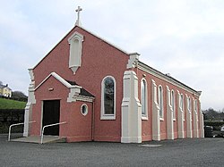 Corpus Cristi Church, Mountfield | |
 Mountfield  Mountfield | |
| Coordinates: 54°38′49″N7°10′09″W / 54.64694°N 7.16917°W | |
| Country | United Kingdom |
| Constituent country | Northern Ireland |
| County | County Tyrone |
| Townland | Aghalane |
| Population (2021) | |
• Total | 903 |
Mountfield (Irish: Achadh Ard) is a small village in County Tyrone, Northern Ireland. It is within the townland of Aghalane, northeast of Omagh. It lies on the A505 road and had a population of 903 in the 2021 Census.[ citation needed ] It is set in a stretch of undulating countryside and is regarded as a gateway to the Sperrin Mountains. [1]
Contents
The village was developed mainly in the 19th century by Sir William McMahon and today is a quiet, tranquil place with its economy dependent on agriculture.
Mountfield is part of the Fermanagh and Omagh District Council area.